


Claix 05-05-2018

jmrobin
User
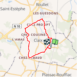

Length
11.2 km

Max alt
135 m

Uphill gradient
194 m
Km-Effort
13.8 km

Min alt
50 m

Downhill gradient
197 m
Boucle
Yes
Creation date :
2019-03-04 10:37:31.387
Updated on :
2019-03-04 10:37:31.415
2h27
Difficulty : Easy

FREE GPS app for hiking
 SityTrail
IGN / Geographical institutes
SityTrail Plus
The world is yours!
About
Trail Walking of 11.2 km to be discovered at New Aquitaine, Charente, Claix. This trail is proposed by jmrobin.
Positioning
Country:
France
Region :
New Aquitaine
Department/Province :
Charente
Municipality :
Claix
Location:
Unknown
Start:(Dec)
Start:(UTM)
270309 ; 5048060 (31T) N.
Comments