Trail Walking Ennevelin - Val de Marque - Photo
© OpenStreetMap contributors
Length
Length
30 km
Max alt
Max alt
51 m
Uphill gradient
Uphill gradient
171 m
Km-Effort
Km-Effort  
33 km
Min alt
Min alt
22 m
Downhill gradient
Downhill gradient
168 m
Boucle
Boucle
Yes
Creation date :
2018-06-26 13:45:57.179
Updated on :
2018-06-26 13:45:57.179

(0 Reviews)

Walking
Walking
6h39
Difficulty : Easy

Scan this QR Code to open this trail in the SityTrail application

FREE GPS app for hiking

Logo SityTrail SityTrail

IGN / Geographical institutes

Download SityTrail from the App Store Download SityTrail from Google Play

Logo SityTrail SityTrail World

The world is yours!

Download SityTrail from the App Store Download SityTrail from Google Play Download SityTrail on Huawei AppGallery

About

Trail Walking of 30 km to be discovered at Hauts-de-France, Nord, Ennevelin. This trail is proposed by Chrouanet.

Description

d'Ennevelin à Chéreng en passant par Louvil, Cysoing, Gruson. Retour en flirtant avec le GR 121B.

Elevation profile

Photos

Positioning

Country:
France
Region :
Hauts-de-France
Department/Province :
Nord
Municipality :
Ennevelin
Location:
Unknown
Start:(UTM)
509064 ; 5598712 (31U) N.

Trails nearby

Trail Equestrian Cappelle-en-Pévèle - Boucle des Pavés - Capelle en Pévèle  - Photo
Equestrian
tracegps

Equestrian

Medium
(1)
Cappelle-en-Pévèle, Hauts-de-France, Nord, France
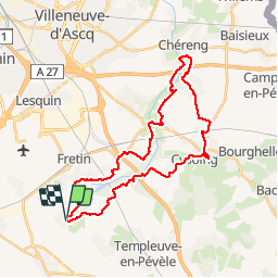
17.7 km | 18.7 km-effort
2h 45min
Yes
Trail Walking Ennevelin - Circuit d'Aigremont - Photo
Walking
tracegps

Walking

Medium
(1)
Ennevelin, Hauts-de-France, Nord, France
11.1 km | 11.8 km-effort
2h 45min
Yes
Trail Walking Péronne-en-Mélantois - Péronne en Mélantois et ses marais - Photo
Walking
tracegps

Walking

Medium
(1)
Péronne-en-Mélantois, Hauts-de-France, Nord, France
13.1 km | 14 km-effort
3h 15min
Yes
Trail Walking Fretin - Mélantois - La Marque - Photo
Walking
Greg813

Walking

Easy
(1)
Fretin, Hauts-de-France, Nord, France
13.9 km | 14.9 km-effort
3h 10min
Yes
Trail Walking Fretin - Sur les traces de Philippe II Auguste - Photo
Walking

Walking

Easy
(1)
Fretin, Hauts-de-France, Nord, France
26 km | 28 km-effort
5h 12min
Yes
Trail Walking Fretin - fretin et ses marais - Photo
Walking
dehemjacques

Walking

Easy
(2)
Fretin, Hauts-de-France, Nord, France
12 km | 12.7 km-effort
2h 31min
Yes
Trail Walking Bouvines - Bouvines 16,2 km - Photo
Walking
GUIDE
rvapeldo

Walking

Easy
Bouvines, Hauts-de-France, Nord, France
16.2 km | 17.3 km-effort
4h 26min
Yes
Trail Walking Avelin - circuit des chicons - Photo
Walking
dehemjacques

Walking

Easy
Avelin, Hauts-de-France, Nord, France
11.7 km | 12.5 km-effort
2h 21min
Yes
Trail On foot Fretin - Fretin - Seclin par le GR121B (option Phalempin) - Photo
On foot

On foot

Medium
Fretin, Hauts-de-France, Nord, France
23 km | 25 km-effort
5h 41min
No


Close
My subscriptions