


Vassivière

cron
User
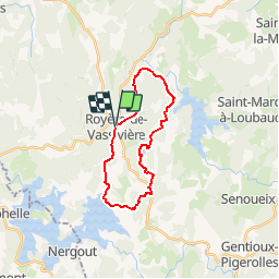

Length
20 km

Max alt
776 m

Uphill gradient
386 m
Km-Effort
25 km

Min alt
646 m

Downhill gradient
390 m
Boucle
Yes
Creation date :
2018-06-26 13:51:40.417
Updated on :
2018-06-26 13:51:40.417
5h29
Difficulty : Medium

FREE GPS app for hiking
 SityTrail
IGN / Geographical institutes
SityTrail Plus
The world is yours!
About
Trail Walking of 20 km to be discovered at New Aquitaine, Creuse, Royère-de-Vassivière. This trail is proposed by cron.
Positioning
Country:
France
Region :
New Aquitaine
Department/Province :
Creuse
Municipality :
Royère-de-Vassivière
Location:
Unknown
Start:(Dec)
Start:(UTM)
415444 ; 5076982 (31T) N.
Comments
très belle randonnée. nous avons beaucoup apprécié. Bon bain de nature.