


Tour Vanoise .Etape 4

rafa77
User
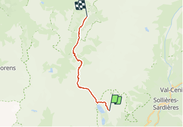

Length
15.6 km

Max alt
2914 m

Uphill gradient
721 m
Km-Effort
27 km

Min alt
1714 m

Downhill gradient
1320 m
Boucle
No
Creation date :
2014-12-10 00:00:00.0
Updated on :
2014-12-10 00:00:00.0
--
Difficulty : Medium

FREE GPS app for hiking
 SityTrail
IGN / Geographical institutes
SityTrail Plus
The world is yours!
About
Trail Walking of 15.6 km to be discovered at Auvergne-Rhône-Alpes, Savoy, Aussois. This trail is proposed by rafa77.
Description
Du refuge Plan Sec au refuge Le Repoju
Positioning
Country:
France
Region :
Auvergne-Rhône-Alpes
Department/Province :
Savoy
Municipality :
Aussois
Location:
Unknown
Start:(Dec)
Start:(UTM)
321968 ; 5014026 (32T) N.
Comments