


FLORIDOR-PLAN DIEBOLD

patrickbeyrath
User
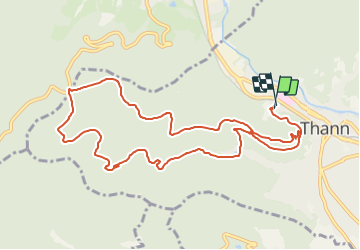

Length
11.1 km

Max alt
695 m

Uphill gradient
453 m
Km-Effort
17.2 km

Min alt
341 m

Downhill gradient
463 m
Boucle
Yes
Creation date :
2018-10-13 05:53:59.274
Updated on :
2018-10-13 05:53:59.301
--
Difficulty : Medium

FREE GPS app for hiking
 SityTrail
IGN / Geographical institutes
SityTrail Plus
The world is yours!
About
Trail Walking of 11.1 km to be discovered at Grand Est, Haut-Rhin, Thann. This trail is proposed by patrickbeyrath.
Description
Version rallongée de la marche du FLORIDOR
Positioning
Country:
France
Region :
Grand Est
Department/Province :
Haut-Rhin
Municipality :
Thann
Location:
Unknown
Start:(Dec)
Start:(UTM)
357253 ; 5297204 (32T) N.
Comments