


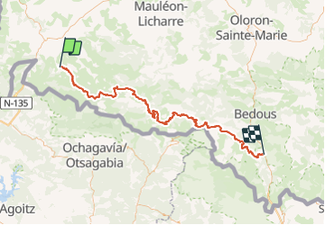
GR10 B (Esterencuby Etsautgpx)

Orphidios
User

Length
107 km

Max alt
1943 m

Uphill gradient
6115 m
Km-Effort
187 km

Min alt
237 m

Downhill gradient
5703 m
Boucle
No
Creation date :
2018-06-26 15:41:43.195
Updated on :
2018-06-26 15:41:43.195
36h22
Difficulty : Medium

FREE GPS app for hiking
 SityTrail
IGN / Geographical institutes
SityTrail Plus
The world is yours!
About
Trail Walking of 107 km to be discovered at New Aquitaine, Pyrénées-Atlantiques, Estérençuby. This trail is proposed by Orphidios.
Description
GR10 Tronçon BEsterencuby à EtsautImporté depuis gr10.fr
Positioning
Country:
France
Region :
New Aquitaine
Department/Province :
Pyrénées-Atlantiques
Municipality :
Estérençuby
Location:
Unknown
Start:(Dec)
Start:(UTM)
646815 ; 4773972 (30T) N.
Comments