


boucle BAÏGURA

pacha56
User
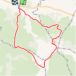

Length
9.5 km

Max alt
885 m

Uphill gradient
728 m
Km-Effort
19.2 km

Min alt
170 m

Downhill gradient
728 m
Boucle
Yes
Creation date :
2018-06-26 15:46:13.443
Updated on :
2018-06-26 15:46:13.443
5h10
Difficulty : Medium

FREE GPS app for hiking
 SityTrail
IGN / Geographical institutes
SityTrail Plus
The world is yours!
About
Trail Walking of 9.5 km to be discovered at New Aquitaine, Pyrénées-Atlantiques, Macaye. This trail is proposed by pacha56.
Description
boucle avec de beaux paysages
Positioning
Country:
France
Region :
New Aquitaine
Department/Province :
Pyrénées-Atlantiques
Municipality :
Macaye
Location:
Unknown
Start:(Dec)
Start:(UTM)
636976 ; 4796774 (30T) N.
Comments