


MANOT LA CHAPELLE

LaurentBernard
User
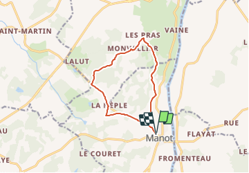

Length
11.1 km

Max alt
228 m

Uphill gradient
149 m
Km-Effort
13.1 km

Min alt
157 m

Downhill gradient
150 m
Boucle
Yes
Creation date :
2018-06-26 15:53:51.773
Updated on :
2018-06-26 15:53:51.773
5h00
Difficulty : Medium

FREE GPS app for hiking
 SityTrail
IGN / Geographical institutes
SityTrail Plus
The world is yours!
About
Trail Walking of 11.1 km to be discovered at New Aquitaine, Charente, Manot. This trail is proposed by LaurentBernard.
Positioning
Country:
France
Region :
New Aquitaine
Department/Province :
Charente
Municipality :
Manot
Location:
Unknown
Start:(Dec)
Start:(UTM)
316682 ; 5090512 (31T) N.
Comments