


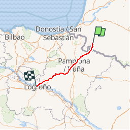
Compostelle 2016 - St-Jean-Pied-de-Port -> Logroño

uru2010
User

Length
175 km

Max alt
1427 m

Uphill gradient
4142 m
Km-Effort
230 km

Min alt
162 m

Downhill gradient
3904 m
Boucle
No
Creation date :
2018-06-26 16:22:48.663
Updated on :
2018-06-26 16:22:48.663
43h45
Difficulty : Difficult

FREE GPS app for hiking
 SityTrail
IGN / Geographical institutes
SityTrail Plus
The world is yours!
About
Trail Walking of 175 km to be discovered at New Aquitaine, Pyrénées-Atlantiques, Saint-Jean-Pied-de-Port. This trail is proposed by uru2010.
Description
Chemin de St Jacques de Compostelle en 2016 :
St-Jean-Pied-de-Port -> Logroño
Positioning
Country:
France
Region :
New Aquitaine
Department/Province :
Pyrénées-Atlantiques
Municipality :
Saint-Jean-Pied-de-Port
Location:
Unknown
Start:(Dec)
Start:(UTM)
643223 ; 4780404 (30T) N.
Comments