


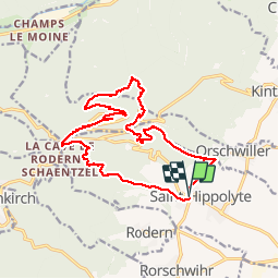
St-Hippolyte - Haut-Koenigsbourg

nfranche
User

Length
17.3 km

Max alt
732 m

Uphill gradient
729 m
Km-Effort
27 km

Min alt
251 m

Downhill gradient
731 m
Boucle
Yes
Creation date :
2018-06-26 16:29:49.615
Updated on :
2018-06-26 16:29:49.615
5h35
Difficulty : Unknown

FREE GPS app for hiking
 SityTrail
IGN / Geographical institutes
SityTrail Plus
The world is yours!
About
Trail Walking of 17.3 km to be discovered at Grand Est, Haut-Rhin, Saint-Hippolyte. This trail is proposed by nfranche.
Description
Beau circuit quasiment intégralement en sentier forestier, au départ du village de St-Hippolyte - Abri du pain d'épices - Haut et Petit Koenigsbourg - col de Schaentzel
Positioning
Country:
France
Region :
Grand Est
Department/Province :
Haut-Rhin
Municipality :
Saint-Hippolyte
Location:
Unknown
Start:(Dec)
Start:(UTM)
378653 ; 5343451 (32U) N.
Comments