


dom

bert16
User
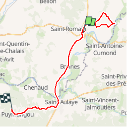

Length
27 km

Max alt
129 m

Uphill gradient
446 m
Km-Effort
33 km

Min alt
34 m

Downhill gradient
425 m
Boucle
No
Creation date :
2019-01-15 12:13:17.251
Updated on :
2019-01-15 12:13:17.251
3h14
Difficulty : Easy

FREE GPS app for hiking
 SityTrail
IGN / Geographical institutes
SityTrail Plus
The world is yours!
About
Trail Walking of 27 km to be discovered at New Aquitaine, Charente, Aubeterre-sur-Dronne. This trail is proposed by bert16.
Photos


Positioning
Country:
France
Region :
New Aquitaine
Department/Province :
Charente
Municipality :
Aubeterre-sur-Dronne
Location:
Unknown
Start:(Dec)
Start:(UTM)
277971 ; 5017079 (31T) N.
Comments