![](/images/other/stat-length.png)
![Excursión Senderismo Vandy - Le Bouiillon - Photo](https://media.geolcdn.com/t/1900/400/ext.pjpeg?maxdim=2&url=https%3A%2F%2Fstatic1.geolcdn.com%2Fsiteimages%2Fupload%2Ffiles%2F1553511878bg_sport_marche.png)
Le Bouiillon
Lajoie
Usuario
![Longitud](/images/other/stat-length.png)
Longitud
11,3 km
![Altitud máxima](https://static1.geolcdn.com/siteimages/upload/files/1508320355ic_sort_altitude_max_24dp.png)
Altitud máxima
184 m
![Desnivel positivo](https://static1.geolcdn.com/siteimages/upload/files/1508320355ic_sort_den_pos_24dp.png)
Desnivel positivo
202 m
![Km-Effort](/images/other/stat-length.png)
Km-Effort
14 km
![Altitud mínima](https://static1.geolcdn.com/siteimages/upload/files/1508320355ic_sort_altitude_min_24dp.png)
Altitud mínima
95 m
![Desnivel negativo](https://static1.geolcdn.com/siteimages/upload/files/1508320355ic_sort_den_neg_24dp.png)
Desnivel negativo
204 m
![Boucle](https://static1.geolcdn.com/siteimages/upload/files/16400158638029165_repeat_loop_refresh_sync_direction_icon.png)
Boucle
Sí
Fecha de creación :
2014-12-10 00:00:00.0
Última modificación :
2014-12-10 00:00:00.0
![Senderismo](https://static1.geolcdn.com/sitytour/trail-icons/101.png)
3h25
Dificultad : Medio
![Escanee este código QR para abrir la excursión en la aplicación SityTrail](https://capi.geolives.com/qq0zvz2zws4bq2lad0pu/sitytour/trails/134515/qr.png?size=200)
Aplicación GPS de excursión GRATIS
A propósito
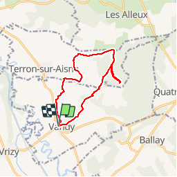
Ruta Senderismo de 11,3 km a descubrir en Gran Este, Ardenas, Vandy. Esta ruta ha sido propuesta por Lajoie.
Descripción
Départ place de Vandy,Passage difficile Le Rainot, belle vue sur le village de Terron/Aisne, éffectuer le Mont Dingon, superbe vue sur la vallée de Malva, à faire quand les foins sont fauchés, passage difficile Les Coursons
Localización
País:
France
Región :
Gran Este
Departamento/provincia :
Ardenas
Municipio :
Vandy
Localidad:
Unknown
Salida:(Dec)
Salida:(UTM)
623550 ; 5477121 (31U) N.
Comentarios
Excursiones cerca
![Excursión Senderismo Ballay - Le tour de Toges - Ballay - Photo](https://media.geolcdn.com/t/375/260/ext.jpg?maxdim=2&url=https%3A%2F%2Fservices.sitytrail.com%2FGeolivesWS%2FDownloadMedia.ashx%3FTrailID%3D172274%26Media%3D13590_1.jpg)
![Senderismo Senderismo](https://static1.geolcdn.com/sitytour/trail-icons/101.png)
Le tour de Toges - Ballay
Senderismo
Medio
Ballay,
Gran Este,
Ardenas,
France
![](/images/other/stat-length.png)
12,5 km | 14,8 km-effort
3h 0min
![](https://static1.geolcdn.com/siteimages/upload/files/16400158638029165_repeat_loop_refresh_sync_direction_icon.png)
Sí
![Excursión Senderismo Ballay - Les Bois de Landéves - Ballay - Photo](https://media.geolcdn.com/t/375/260/ext.jpg?maxdim=2&url=https%3A%2F%2Fservices.sitytrail.com%2FGeolivesWS%2FDownloadMedia.ashx%3FTrailID%3D172272%26Media%3D13587_1.jpg)
![Senderismo Senderismo](https://static1.geolcdn.com/sitytour/trail-icons/101.png)
Les Bois de Landéves - Ballay
Senderismo
Medio
Ballay,
Gran Este,
Ardenas,
France
![](/images/other/stat-length.png)
9,6 km | 12,3 km-effort
2h 30min
![](https://static1.geolcdn.com/siteimages/upload/files/16400158638029165_repeat_loop_refresh_sync_direction_icon.png)
Sí
![Excursión Senderismo Quatre-Champs - La forêt de Vandy - Quatre Champs - Photo](https://media.geolcdn.com/t/375/260/ext.jpg?maxdim=2&url=https%3A%2F%2Fservices.sitytrail.com%2FGeolivesWS%2FDownloadMedia.ashx%3FTrailID%3D172271%26Media%3D13585_1.jpg)
![Senderismo Senderismo](https://static1.geolcdn.com/sitytour/trail-icons/101.png)
La forêt de Vandy - Quatre Champs
Senderismo
Medio
Quatre-Champs,
Gran Este,
Ardenas,
France
![](/images/other/stat-length.png)
10,4 km | 13,4 km-effort
3h 0min
![](https://static1.geolcdn.com/siteimages/upload/files/16400158638029165_repeat_loop_refresh_sync_direction_icon.png)
Sí
![Excursión Senderismo Vouziers - condé 2 - Photo](https://media.geolcdn.com/t/375/260/ext.jpg?maxdim=2&url=https%3A%2F%2Fstatic1.geolcdn.com%2Fsiteimages%2Fupload%2Ffiles%2F1553511878bg_sport_marche.png)
![Senderismo Senderismo](https://static1.geolcdn.com/sitytour/trail-icons/101.png)
condé 2
Senderismo
Muy fácil
Vouziers,
Gran Este,
Ardenas,
France
![](/images/other/stat-length.png)
5,5 km | 5,7 km-effort
1h 39min
![](https://static1.geolcdn.com/siteimages/upload/files/16400158638029165_repeat_loop_refresh_sync_direction_icon.png)
Sí
![Excursión Senderismo Vouziers - condé 1 - Photo](https://media.geolcdn.com/t/375/260/ext.jpg?maxdim=2&url=https%3A%2F%2Fstatic1.geolcdn.com%2Fsiteimages%2Fupload%2Ffiles%2F1553511878bg_sport_marche.png)
![Senderismo Senderismo](https://static1.geolcdn.com/sitytour/trail-icons/101.png)
condé 1
Senderismo
Muy fácil
Vouziers,
Gran Este,
Ardenas,
France
![](/images/other/stat-length.png)
11,4 km | 12 km-effort
3h 54min
![](https://static1.geolcdn.com/siteimages/upload/files/16400158638029165_repeat_loop_refresh_sync_direction_icon.png)
No
![Excursión Marcha nórdica Vouziers - Les Pâquis maison - Photo](https://media.geolcdn.com/t/375/260/ext.jpg?maxdim=2&url=https%3A%2F%2Fstatic1.geolcdn.com%2Fsiteimages%2Fupload%2Ffiles%2F1545311037marcheuse_200dpi.jpg)
![Marcha nórdica Marcha nórdica](https://static1.geolcdn.com/sitytour/trail-icons/102.png)
Les Pâquis maison
Marcha nórdica
Vouziers,
Gran Este,
Ardenas,
France
![](/images/other/stat-length.png)
3,2 km | 3,7 km-effort
1h 0min
![](https://static1.geolcdn.com/siteimages/upload/files/16400158638029165_repeat_loop_refresh_sync_direction_icon.png)
Sí
![Excursión Bici de montaña Vouziers - rando - Photo](https://media.geolcdn.com/t/375/260/ext.jpg?maxdim=2&url=https%3A%2F%2Fstatic1.geolcdn.com%2Fsiteimages%2Fupload%2Ffiles%2F1524743154velo.jpg)
![Bici de montaña Bici de montaña](https://static1.geolcdn.com/sitytour/trail-icons/202.png)
rando
Bici de montaña
Muy difícil
Vouziers,
Gran Este,
Ardenas,
France
![](/images/other/stat-length.png)
71 km | 88 km-effort
3h 40min
![](https://static1.geolcdn.com/siteimages/upload/files/16400158638029165_repeat_loop_refresh_sync_direction_icon.png)
No