![](/images/other/stat-length.png)
![Excursión Senderismo Mont-Dore - Crètes du Val de Courre - Photo](https://media.geolcdn.com/t/1900/400/ext.pjpeg?maxdim=2&url=https%3A%2F%2Fservices.sitytrail.com%2FGeolivesWS%2FDownloadMedia.ashx%3FTrailID%3D139789%26Media%3D61587b5c-19e7-453c-a3d8-ce89fca3adfa.jpg)
Crètes du Val de Courre
jmc63
Usuario
![Longitud](/images/other/stat-length.png)
Longitud
5,9 km
![Altitud máxima](https://static1.geolcdn.com/siteimages/upload/files/1508320355ic_sort_altitude_max_24dp.png)
Altitud máxima
1752 m
![Desnivel positivo](https://static1.geolcdn.com/siteimages/upload/files/1508320355ic_sort_den_pos_24dp.png)
Desnivel positivo
495 m
![Km-Effort](/images/other/stat-length.png)
Km-Effort
12,5 km
![Altitud mínima](https://static1.geolcdn.com/siteimages/upload/files/1508320355ic_sort_altitude_min_24dp.png)
Altitud mínima
1315 m
![Desnivel negativo](https://static1.geolcdn.com/siteimages/upload/files/1508320355ic_sort_den_neg_24dp.png)
Desnivel negativo
494 m
![Boucle](https://static1.geolcdn.com/siteimages/upload/files/16400158638029165_repeat_loop_refresh_sync_direction_icon.png)
Boucle
Sí
Fecha de creación :
2014-12-10 00:00:00.0
Última modificación :
2014-12-10 00:00:00.0
![Senderismo](https://static1.geolcdn.com/sitytour/trail-icons/101.png)
3h37
Dificultad : Medio
![Escanee este código QR para abrir la excursión en la aplicación SityTrail](https://capi.geolives.com/qq0zvz2zws4bq2lad0pu/sitytour/trails/139789/qr.png?size=200)
Aplicación GPS de excursión GRATIS
A propósito
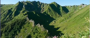
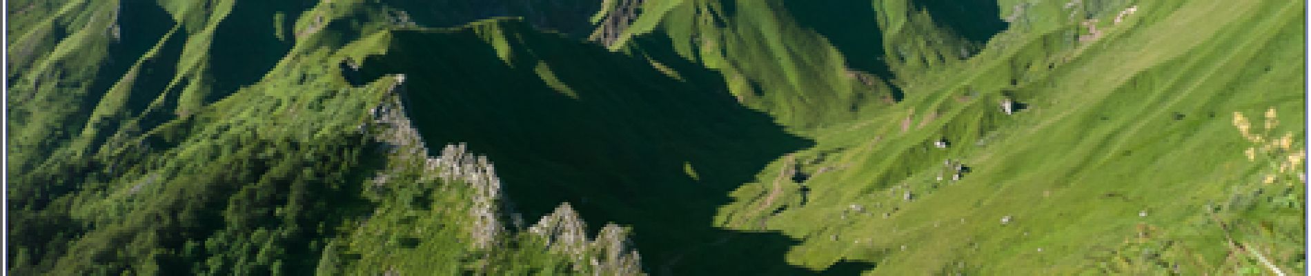
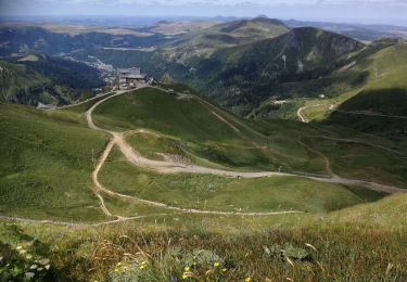
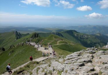
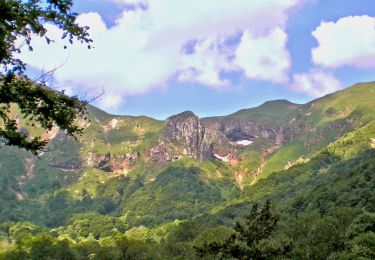
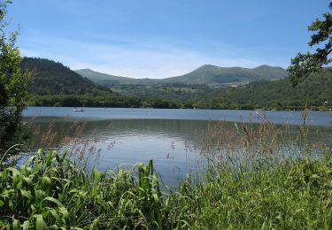
Ruta Senderismo de 5,9 km a descubrir en Auvergne-Rhône-Alpes, Puy-de-Dôme, Mont-Dore. Esta ruta ha sido propuesta por jmc63.
Descripción
Le départ se fait sur le parking de la station du Mont-Dore.Une montée raide vers la crête ouest que l''on suit jusqu''au col de Courre.Descente par l''arète du Puy Redon
Localización
País:
France
Región :
Auvergne-Rhône-Alpes
Departamento/provincia :
Puy-de-Dôme
Municipio :
Mont-Dore
Localidad:
Unknown
Salida:(Dec)
Salida:(UTM)
485364 ; 5043525 (31T) N.
Comentarios
Excursiones cerca
![Excursión Senderismo Mont-Dore - Montée au sommet du Puy de Sancy - Photo](https://media.geolcdn.com/t/375/260/ext.jpg?maxdim=2&url=https%3A%2F%2Fmedia.geolcdn.com%2Ff%2F1486ae36-afa6-41d3-a8cf-03841ddf3ad3.jpg)
![Senderismo Senderismo](https://static1.geolcdn.com/sitytour/trail-icons/101.png)
Montée au sommet du Puy de Sancy
Senderismo
Fácil
(1)
Mont-Dore,
Auvergne-Rhône-Alpes,
Puy-de-Dôme,
France
![](/images/other/stat-length.png)
1,4 km | 2,7 km-effort
40min
![](https://static1.geolcdn.com/siteimages/upload/files/16400158638029165_repeat_loop_refresh_sync_direction_icon.png)
Sí
![Excursión Senderismo Besse-et-Saint-Anastaise - Sancy par Super-Besse - Photo](https://media.geolcdn.com/t/375/260/ext.jpg?maxdim=2&url=https%3A%2F%2Fservices.sitytrail.com%2FGeolivesWS%2FDownloadMedia.ashx%3FTrailID%3D317232%26Media%3D16410_6.jpg)
![Senderismo Senderismo](https://static1.geolcdn.com/sitytour/trail-icons/101.png)
Sancy par Super-Besse
Senderismo
Difícil
(1)
Besse-et-Saint-Anastaise,
Auvergne-Rhône-Alpes,
Puy-de-Dôme,
France
![](/images/other/stat-length.png)
10 km | 19,2 km-effort
3h 0min
![](https://static1.geolcdn.com/siteimages/upload/files/16400158638029165_repeat_loop_refresh_sync_direction_icon.png)
Sí
![Excursión Senderismo Mont-Dore - Mont_Dore_Puy_Sancy - Photo](https://media.geolcdn.com/t/375/260/ext.jpg?maxdim=2&url=https%3A%2F%2Fmedia.geolcdn.com%2Ff%2Ff4820ce9-6e7d-4a26-b9ee-9a17384aeb13.jpg)
![Senderismo Senderismo](https://static1.geolcdn.com/sitytour/trail-icons/101.png)
Mont_Dore_Puy_Sancy
Senderismo
Difícil
(1)
Mont-Dore,
Auvergne-Rhône-Alpes,
Puy-de-Dôme,
France
![](/images/other/stat-length.png)
6,8 km | 13,9 km-effort
2h 0min
![](https://static1.geolcdn.com/siteimages/upload/files/16400158638029165_repeat_loop_refresh_sync_direction_icon.png)
Sí
![Excursión Senderismo Chambon-sur-Lac - Chambon_Vallee_Chaudefour_2 - Photo](https://media.geolcdn.com/t/375/260/ext.jpg?maxdim=2&url=https%3A%2F%2Fmedia.geolcdn.com%2Ff%2Fda5be39b-4529-43e6-9adb-3b826be81a49.JPG)
![Senderismo Senderismo](https://static1.geolcdn.com/sitytour/trail-icons/101.png)
Chambon_Vallee_Chaudefour_2
Senderismo
Difícil
(1)
Chambon-sur-Lac,
Auvergne-Rhône-Alpes,
Puy-de-Dôme,
France
![](/images/other/stat-length.png)
15 km | 26 km-effort
4h 30min
![](https://static1.geolcdn.com/siteimages/upload/files/16400158638029165_repeat_loop_refresh_sync_direction_icon.png)
Sí
![Excursión Senderismo Mont-Dore - Le puy de la tache, le lacs servières et guèry par la cascade du Queureuilh depuis l'Escalidou. - Photo](https://media.geolcdn.com/t/375/260/ext.jpg?maxdim=2&url=https%3A%2F%2Fservices.sitytrail.com%2FGeolivesWS%2FDownloadMedia.ashx%3FTrailID%3D228422%26Media%3D20131022164253.jpg)
![Senderismo Senderismo](https://static1.geolcdn.com/sitytour/trail-icons/101.png)
Le puy de la tache, le lacs servières et guèry par la cascade du Queureuilh d...
Senderismo
Difícil
(3)
Mont-Dore,
Auvergne-Rhône-Alpes,
Puy-de-Dôme,
France
![](/images/other/stat-length.png)
34 km | 50 km-effort
10h 16min
![](https://static1.geolcdn.com/siteimages/upload/files/16400158638029165_repeat_loop_refresh_sync_direction_icon.png)
Sí
![Excursión Senderismo Mont-Dore - le sancy du mont dore par le côté ouest puis revenir par le côté est. - Photo](https://media.geolcdn.com/t/375/260/ext.jpg?maxdim=2&url=https%3A%2F%2Fservices.sitytrail.com%2FGeolivesWS%2FDownloadMedia.ashx%3FTrailID%3D228300%26Media%3D20131021153021.jpg)
![Senderismo Senderismo](https://static1.geolcdn.com/sitytour/trail-icons/101.png)
le sancy du mont dore par le côté ouest puis revenir par le côté est.
Senderismo
Difícil
(2)
Mont-Dore,
Auvergne-Rhône-Alpes,
Puy-de-Dôme,
France
![](/images/other/stat-length.png)
8,2 km | 15,4 km-effort
3h 5min
![](https://static1.geolcdn.com/siteimages/upload/files/16400158638029165_repeat_loop_refresh_sync_direction_icon.png)
Sí
![Excursión Senderismo Mont-Dore - Sentier des crêtes Puy de Sancy - Photo](https://media.geolcdn.com/t/375/260/ext.jpg?maxdim=2&url=https%3A%2F%2Fservices.sitytrail.com%2FGeolivesWS%2FDownloadMedia.ashx%3FTrailID%3D106861%26Media%3D11600_5.jpg)
![Senderismo Senderismo](https://static1.geolcdn.com/sitytour/trail-icons/101.png)
Sentier des crêtes Puy de Sancy
Senderismo
Difícil
(2)
Mont-Dore,
Auvergne-Rhône-Alpes,
Puy-de-Dôme,
France
![](/images/other/stat-length.png)
26 km | 46 km-effort
9h 0min
![](https://static1.geolcdn.com/siteimages/upload/files/16400158638029165_repeat_loop_refresh_sync_direction_icon.png)
Sí
![Excursión A pie Mont-Dore - Le Mont-Dore / Lac Chambon - Photo](https://media.geolcdn.com/t/375/260/ext.jpg?maxdim=2&url=https%3A%2F%2Fmedia.geolcdn.com%2Ff%2F27e89848-a12c-47cd-b677-9d363f0d6285.jpeg)
![A pie A pie](https://static1.geolcdn.com/sitytour/trail-icons/100.png)
Le Mont-Dore / Lac Chambon
A pie
Difícil
Mont-Dore,
Auvergne-Rhône-Alpes,
Puy-de-Dôme,
France
![](/images/other/stat-length.png)
19,4 km | 31 km-effort
7h 6min
![](https://static1.geolcdn.com/siteimages/upload/files/16400158638029165_repeat_loop_refresh_sync_direction_icon.png)
No
![Excursión A pie La Tour-d'Auvergne - Chambourguet - Photo](https://media.geolcdn.com/t/375/260/ext.jpg?maxdim=2&url=https%3A%2F%2Fmedia.geolcdn.com%2Ff%2Fcae5925b-61ac-47d4-b021-c5bfebecd2dc.jpeg)
![A pie A pie](https://static1.geolcdn.com/sitytour/trail-icons/100.png)
Chambourguet
A pie
Medio
La Tour-d'Auvergne,
Auvergne-Rhône-Alpes,
Puy-de-Dôme,
France
![](/images/other/stat-length.png)
16,8 km | 23 km-effort
5h 17min
![](https://static1.geolcdn.com/siteimages/upload/files/16400158638029165_repeat_loop_refresh_sync_direction_icon.png)
Sí
impossible de trouver Le départs