![](/images/other/stat-length.png)
![Excursión Otra actividad Saint-Laurent-du-Pont - La grande Sure depuis la Chartreuse de Curière - Photo](https://media.geolcdn.com/t/1900/400/ext.pjpeg?maxdim=2&url=https%3A%2F%2Fservices.sitytrail.com%2FGeolivesWS%2FDownloadMedia.ashx%3FTrailID%3D210333%26Media%3Dfix__20130804145735.jpg)
La grande Sure depuis la Chartreuse de Curière
teddy38
Usuario
![Longitud](/images/other/stat-length.png)
Longitud
18 km
![Altitud máxima](https://static1.geolcdn.com/siteimages/upload/files/1508320355ic_sort_altitude_max_24dp.png)
Altitud máxima
1904 m
![Desnivel positivo](https://static1.geolcdn.com/siteimages/upload/files/1508320355ic_sort_den_pos_24dp.png)
Desnivel positivo
1048 m
![Km-Effort](/images/other/stat-length.png)
Km-Effort
32 km
![Altitud mínima](https://static1.geolcdn.com/siteimages/upload/files/1508320355ic_sort_altitude_min_24dp.png)
Altitud mínima
876 m
![Desnivel negativo](https://static1.geolcdn.com/siteimages/upload/files/1508320355ic_sort_den_neg_24dp.png)
Desnivel negativo
1052 m
![Boucle](https://static1.geolcdn.com/siteimages/upload/files/16400158638029165_repeat_loop_refresh_sync_direction_icon.png)
Boucle
Sí
Fecha de creación :
2014-12-10 00:00:00.0
Última modificación :
2014-12-10 00:00:00.0
![Otra actividad](https://static1.geolcdn.com/sitytour/trail-icons/900.png)
8h17
Dificultad : Medio
![Escanee este código QR para abrir la excursión en la aplicación SityTrail](https://capi.geolives.com/qq0zvz2zws4bq2lad0pu/sitytour/trails/210333/qr.png?size=200)
Aplicación GPS de excursión GRATIS
A propósito
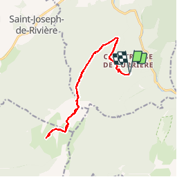
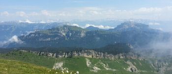
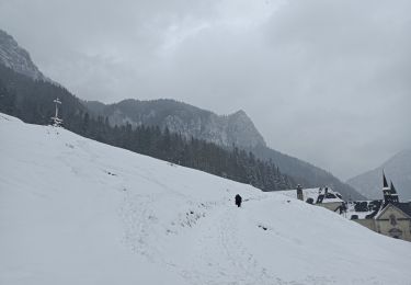
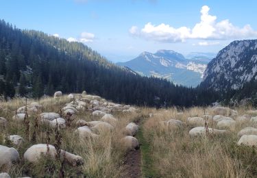
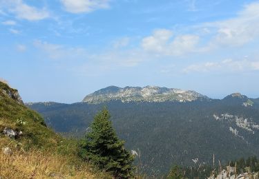
Ruta Otra actividad de 18 km a descubrir en Auvergne-Rhône-Alpes, Isère, Saint-Laurent-du-Pont. Esta ruta ha sido propuesta por teddy38.
Descripción
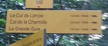
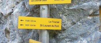
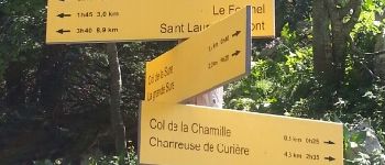
Plus longue que la même ascension depuis le col de la Charmette. Attention le col de la charmette n'est pas accessible depuis St Laurent du pont comme le laisse supposer la carte
Localización
País:
France
Región :
Auvergne-Rhône-Alpes
Departamento/provincia :
Isère
Municipio :
Saint-Laurent-du-Pont
Localidad:
Unknown
Salida:(Dec)
Salida:(UTM)
714928 ; 5026363 (31T) N.
Comentarios
Excursiones cerca
![Excursión Senderismo Saint-Pierre-de-Chartreuse - Le Charmant Som depuis le Col de la Charmette - Photo](https://media.geolcdn.com/t/375/260/ext.jpg?maxdim=2&url=https%3A%2F%2Fservices.sitytrail.com%2FGeolivesWS%2FDownloadMedia.ashx%3FTrailID%3D104129%26Media%3D7202_1.jpg)
![Senderismo Senderismo](https://static1.geolcdn.com/sitytour/trail-icons/101.png)
Le Charmant Som depuis le Col de la Charmette
Senderismo
Medio
(2)
Saint-Pierre-de-Chartreuse,
Auvergne-Rhône-Alpes,
Isère,
France
![](/images/other/stat-length.png)
8,9 km | 17,3 km-effort
5h 0min
![](https://static1.geolcdn.com/siteimages/upload/files/16400158638029165_repeat_loop_refresh_sync_direction_icon.png)
Sí
![Excursión Senderismo Saint-Pierre-de-Chartreuse - Le Charmant Som 1867m, par les dalles - Photo](https://media.geolcdn.com/t/375/260/ext.jpg?maxdim=2&url=https%3A%2F%2Fservices.sitytrail.com%2FGeolivesWS%2FDownloadMedia.ashx%3FTrailID%3D101690%26Media%3D1926_1.jpg)
![Senderismo Senderismo](https://static1.geolcdn.com/sitytour/trail-icons/101.png)
Le Charmant Som 1867m, par les dalles
Senderismo
Medio
(1)
Saint-Pierre-de-Chartreuse,
Auvergne-Rhône-Alpes,
Isère,
France
![](/images/other/stat-length.png)
9,7 km | 21 km-effort
5h 0min
![](https://static1.geolcdn.com/siteimages/upload/files/16400158638029165_repeat_loop_refresh_sync_direction_icon.png)
Sí
![Excursión Senderismo Saint-Pierre-de-Chartreuse - Les haberts du Désert de Chartreuse - Photo](https://media.geolcdn.com/t/375/260/ext.jpg?maxdim=2&url=https%3A%2F%2Fservices.sitytrail.com%2FGeolivesWS%2FDownloadMedia.ashx%3FTrailID%3D101549%26Media%3D1655_1.jpg)
![Senderismo Senderismo](https://static1.geolcdn.com/sitytour/trail-icons/101.png)
Les haberts du Désert de Chartreuse
Senderismo
Medio
(1)
Saint-Pierre-de-Chartreuse,
Auvergne-Rhône-Alpes,
Isère,
France
![](/images/other/stat-length.png)
10,9 km | 21 km-effort
5h 0min
![](https://static1.geolcdn.com/siteimages/upload/files/16400158638029165_repeat_loop_refresh_sync_direction_icon.png)
Sí
![Excursión Senderismo Saint-Christophe-sur-Guiers - Petit Som 1772m, depuis La Ruchère - Photo](https://media.geolcdn.com/t/375/260/ext.jpg?maxdim=2&url=https%3A%2F%2Fservices.sitytrail.com%2FGeolivesWS%2FDownloadMedia.ashx%3FTrailID%3D101428%26Media%3D1421_1.jpg)
![Senderismo Senderismo](https://static1.geolcdn.com/sitytour/trail-icons/101.png)
Petit Som 1772m, depuis La Ruchère
Senderismo
Medio
(2)
Saint-Christophe-sur-Guiers,
Auvergne-Rhône-Alpes,
Isère,
France
![](/images/other/stat-length.png)
6 km | 13,2 km-effort
3h 30min
![](https://static1.geolcdn.com/siteimages/upload/files/16400158638029165_repeat_loop_refresh_sync_direction_icon.png)
Sí
![Excursión Senderismo Saint-Christophe-sur-Guiers - Petit Som par le Col de la Ruchère - Photo](https://media.geolcdn.com/t/375/260/ext.jpg?maxdim=2&url=https%3A%2F%2Fservices.sitytrail.com%2FGeolivesWS%2FDownloadMedia.ashx%3FTrailID%3D187990%26Media%3D84dca246-9935-47c1-bea7-9350caca3e85.JPG)
![Senderismo Senderismo](https://static1.geolcdn.com/sitytour/trail-icons/101.png)
Petit Som par le Col de la Ruchère
Senderismo
Medio
(2)
Saint-Christophe-sur-Guiers,
Auvergne-Rhône-Alpes,
Isère,
France
![](/images/other/stat-length.png)
7,1 km | 15,2 km-effort
3h 5min
![](https://static1.geolcdn.com/siteimages/upload/files/16400158638029165_repeat_loop_refresh_sync_direction_icon.png)
Sí
![Excursión Senderismo Saint-Pierre-de-Chartreuse - grande sure - Photo](https://media.geolcdn.com/t/375/260/ext.jpg?maxdim=2&url=https%3A%2F%2Fstatic1.geolcdn.com%2Fsiteimages%2Fupload%2Ffiles%2F1553511878bg_sport_marche.png)
![Senderismo Senderismo](https://static1.geolcdn.com/sitytour/trail-icons/101.png)
grande sure
Senderismo
Medio
(2)
Saint-Pierre-de-Chartreuse,
Auvergne-Rhône-Alpes,
Isère,
France
![](/images/other/stat-length.png)
12,8 km | 22 km-effort
4h 39min
![](https://static1.geolcdn.com/siteimages/upload/files/16400158638029165_repeat_loop_refresh_sync_direction_icon.png)
Sí
![Excursión Senderismo Saint-Pierre-de-Chartreuse - Monastère de la Grande Chartreuse - Photo](https://media.geolcdn.com/t/375/260/ext.jpg?maxdim=2&url=https%3A%2F%2Fmedia.geolcdn.com%2Ff%2Fe7a4c8ad-7c07-49bf-b2d9-5ec8c2525655.jpg)
![Senderismo Senderismo](https://static1.geolcdn.com/sitytour/trail-icons/101.png)
Monastère de la Grande Chartreuse
Senderismo
Medio
Saint-Pierre-de-Chartreuse,
Auvergne-Rhône-Alpes,
Isère,
France
![](/images/other/stat-length.png)
6,1 km | 11 km-effort
2h 29min
![](https://static1.geolcdn.com/siteimages/upload/files/16400158638029165_repeat_loop_refresh_sync_direction_icon.png)
Sí
![Excursión Senderismo Saint-Pierre-de-Chartreuse - 020923 Grand Som Par le Pas de Suiffière - Photo](https://media.geolcdn.com/t/375/260/ext.jpg?maxdim=2&url=https%3A%2F%2Fmedia.geolcdn.com%2Ff%2F8a00fd66-5443-4b70-a043-6a2c1cd393f7.jpg)
![Senderismo Senderismo](https://static1.geolcdn.com/sitytour/trail-icons/101.png)
020923 Grand Som Par le Pas de Suiffière
Senderismo
Muy difícil
Saint-Pierre-de-Chartreuse,
Auvergne-Rhône-Alpes,
Isère,
France
![](/images/other/stat-length.png)
12,9 km | 28 km-effort
6h 50min
![](https://static1.geolcdn.com/siteimages/upload/files/16400158638029165_repeat_loop_refresh_sync_direction_icon.png)
No
![Excursión Senderismo Proveysieux - charmant som de la Charmette - Photo](https://media.geolcdn.com/t/375/260/ext.jpg?maxdim=2&url=https%3A%2F%2Fmedia.geolcdn.com%2Ff%2F04337560-1d00-437c-af05-36add3e9d3d8.jpg)
![Senderismo Senderismo](https://static1.geolcdn.com/sitytour/trail-icons/101.png)
charmant som de la Charmette
Senderismo
Medio
Proveysieux,
Auvergne-Rhône-Alpes,
Isère,
France
![](/images/other/stat-length.png)
8,7 km | 16,9 km-effort
6h 10min
![](https://static1.geolcdn.com/siteimages/upload/files/16400158638029165_repeat_loop_refresh_sync_direction_icon.png)
Sí