Excursión Senderismo Laveissière - Font d’allagnon Sécheuse par Bec de l’aigle - Photo

Font d’allagnon Sécheuse par Bec de l’aigle

 phlassus
phlassus

Usuario

© OpenStreetMap contributors
Longitud
Longitud
18,5 km
Altitud máxima
Altitud máxima
1683 m
Desnivel positivo
Desnivel positivo
1060 m
Km-Effort
Km-Effort  
33 km
Altitud mínima
Altitud mínima
1191 m
Desnivel negativo
Desnivel negativo
1059 m
Boucle
Boucle
Fecha de creación :
2019-08-17 08:23:28.0
Última modificación :
2019-08-17 15:13:06.315

(0 Opinión)

Senderismo
Senderismo
5h49
Dificultad : Muy difícil

Escanee este código QR para abrir la excursión en la aplicación SityTrail

Aplicación GPS de excursión GRATIS

Logo SityTrail SityTrail

IGN / Institutos geográficos

Descargar SityTrail en App Store Descargar SityTrail en Google Play

Logo SityTrail SityTrail World

El mundo es suyo

Descargar SityTrail en App Store Descargar SityTrail en Google Play Descargar SityTrail en Huawei AppGallery

A propósito

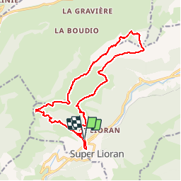
Ruta Senderismo de 18,5 km a descubrir en Auvergne-Rhône-Alpes, Cantal, Laveissière. Esta ruta ha sido propuesta por phlassus.

Descripción

Départ à fond d’Allagnon monter au bec de l’aigle ensuite puy de sécheuse et téton de venus

Perfil altimétrico

Localización

País:
France
Región :
Auvergne-Rhône-Alpes
Departamento/provincia :
Cantal
Municipio :
Laveissière
Localidad:
Unknown
Salida:(Dec)
Salida:(UTM)
479777 ; 4992751 (31T) N.

Excursiones cerca

Excursión Senderismo Albepierre-Bredons - Cantal - Col de Prat de Bouc Le Plomb du Cantal - 8.2km 450m 2h45 - 2019 07 06 - Photo
Senderismo
Orcal37

Senderismo

Medio
(1)
Albepierre-Bredons, Auvergne-Rhône-Alpes, Cantal, France
8,2 km | 14,2 km-effort
2h 45min
Excursión Senderismo Lavigerie - Le Puy de Peyre Arse depuis la Gravière - Photo
Senderismo
tracegps

Senderismo

Difícil
(2)
Lavigerie, Auvergne-Rhône-Alpes, Cantal, France
11,2 km | 21 km-effort
4h 0min
Excursión Senderismo Laveissière - Le Puy Griou de Super Lioran - Photo
Senderismo
tracegps

Senderismo

Medio
(2)
Laveissière, Auvergne-Rhône-Alpes, Cantal, France
11,9 km | 19,7 km-effort
5h 0min
Excursión Senderismo Laveissière - Le plomb du Cantal - Le Lioran - Photo
Senderismo
tracegps

Senderismo

Medio
(1)
Laveissière, Auvergne-Rhône-Alpes, Cantal, France
14,4 km | 27 km-effort
6h 0min
Excursión Senderismo Laveissière - Les crêtes du Cantal - Le Lioran - Photo
Senderismo
tracegps

Senderismo

Difícil
(4)
Laveissière, Auvergne-Rhône-Alpes, Cantal, France
28 km | 51 km-effort
7h 30min
Excursión Senderismo Laveissière - le Peyre Arse - Le Lioran - Photo
Senderismo
tracegps

Senderismo

Difícil
(1)
Laveissière, Auvergne-Rhône-Alpes, Cantal, France
11,2 km | 19,4 km-effort
4h 0min
No
Excursión Senderismo Laveissière - Lioran 2023-08-18 Col de Rombière Col du Pertus A/R - Photo
Senderismo
marionneau

Senderismo

Fácil
(1)
Laveissière, Auvergne-Rhône-Alpes, Cantal, France
12,5 km | 18,8 km-effort
4h 14min
Excursión Senderismo Laveissière - Lioran 2023-08-11 Col du Pertus - Photo
Senderismo
marionneau

Senderismo

Medio
(1)
Laveissière, Auvergne-Rhône-Alpes, Cantal, France
17,3 km | 25 km-effort
2h 57min
Excursión Senderismo Laveissière - Lioran 2023-08-09 Puy de Seycheuse - Photo
Senderismo
marionneau

Senderismo

Muy difícil
(1)
Laveissière, Auvergne-Rhône-Alpes, Cantal, France
13,9 km | 23 km-effort
5h 20min


Cerrar
Mis suscripciones