![](/images/other/stat-length.png)
![Excursión Senderismo Saint-Julien-en-Saint-Alban - 26 st julien st alban - Photo](https://media.geolcdn.com/t/1900/400/ext.pjpeg?maxdim=2&url=https%3A%2F%2Fmedia.geolcdn.com%2Ff%2F72223395-ae45-47d3-9244-8a794d0c42a3.jpg)
26 st julien st alban
randodyssée
Usuario
![Longitud](/images/other/stat-length.png)
Longitud
21 km
![Altitud máxima](https://static1.geolcdn.com/siteimages/upload/files/1508320355ic_sort_altitude_max_24dp.png)
Altitud máxima
672 m
![Desnivel positivo](https://static1.geolcdn.com/siteimages/upload/files/1508320355ic_sort_den_pos_24dp.png)
Desnivel positivo
688 m
![Km-Effort](/images/other/stat-length.png)
Km-Effort
30 km
![Altitud mínima](https://static1.geolcdn.com/siteimages/upload/files/1508320355ic_sort_altitude_min_24dp.png)
Altitud mínima
107 m
![Desnivel negativo](https://static1.geolcdn.com/siteimages/upload/files/1508320355ic_sort_den_neg_24dp.png)
Desnivel negativo
687 m
![Boucle](https://static1.geolcdn.com/siteimages/upload/files/16400158638029165_repeat_loop_refresh_sync_direction_icon.png)
Boucle
Sí
Fecha de creación :
2020-05-21 08:08:22.119
Última modificación :
2020-05-21 21:50:22.708
![Senderismo](https://static1.geolcdn.com/sitytour/trail-icons/101.png)
7h20
Dificultad : Medio
![Escanee este código QR para abrir la excursión en la aplicación SityTrail](https://capi.geolives.com/qq0zvz2zws4bq2lad0pu/sitytour/trails/2405249/qr.png?size=200)
Aplicación GPS de excursión GRATIS
A propósito
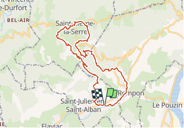
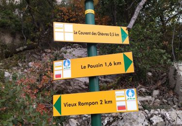
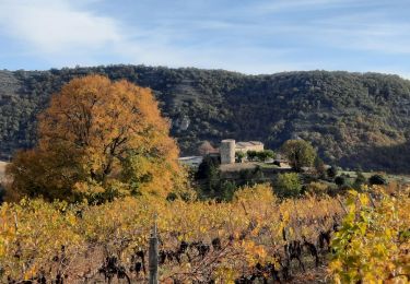
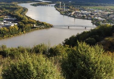
Ruta Senderismo de 21 km a descubrir en Auvergne-Rhône-Alpes, Ardecha, Saint-Julien-en-Saint-Alban. Esta ruta ha sido propuesta por randodyssée.
Descripción
Antoine Martine Renee Joëlle gêne bety
petite rallonge aujourd hui 21 05 2020
chaud
Localización
País:
France
Región :
Auvergne-Rhône-Alpes
Departamento/provincia :
Ardecha
Municipio :
Saint-Julien-en-Saint-Alban
Localidad:
Unknown
Salida:(Dec)
Salida:(UTM)
635065 ; 4957224 (31T) N.
Comentarios
Excursiones cerca
![Excursión Senderismo Le Pouzin - le Pouzin le couvent des Chèvres vieux Rompon - Photo](https://media.geolcdn.com/t/375/260/ext.jpg?maxdim=2&url=https%3A%2F%2Fmedia.geolcdn.com%2Ff%2F2a1fff91-e20b-436c-b942-1b82467f68e9.jpg)
![Senderismo Senderismo](https://static1.geolcdn.com/sitytour/trail-icons/101.png)
le Pouzin le couvent des Chèvres vieux Rompon
Senderismo
Fácil
Le Pouzin,
Auvergne-Rhône-Alpes,
Ardecha,
France
![](/images/other/stat-length.png)
7,9 km | 12,4 km-effort
2h 49min
![](https://static1.geolcdn.com/siteimages/upload/files/16400158638029165_repeat_loop_refresh_sync_direction_icon.png)
Sí
![Excursión Senderismo Saint-Julien-en-Saint-Alban - saint julien en Saint Alban-Le Pouzain 07 - Photo](https://media.geolcdn.com/t/375/260/ext.jpg?maxdim=2&url=https%3A%2F%2Fmedia.geolcdn.com%2Ff%2F1e4688d6-1dfb-4151-9a3f-8e9b2b55e268.jpg)
![Senderismo Senderismo](https://static1.geolcdn.com/sitytour/trail-icons/101.png)
saint julien en Saint Alban-Le Pouzain 07
Senderismo
Muy fácil
Saint-Julien-en-Saint-Alban,
Auvergne-Rhône-Alpes,
Ardecha,
France
![](/images/other/stat-length.png)
35 km | 40 km-effort
2h 0min
![](https://static1.geolcdn.com/siteimages/upload/files/16400158638029165_repeat_loop_refresh_sync_direction_icon.png)
No
![Excursión Senderismo Baix - 07 baix 07 01 23 - Photo](https://media.geolcdn.com/t/375/260/ext.jpg?maxdim=2&url=https%3A%2F%2Fmedia.geolcdn.com%2Ff%2F6f38ce73-6c19-4eb6-98ff-8ad86517b683.jpg)
![Senderismo Senderismo](https://static1.geolcdn.com/sitytour/trail-icons/101.png)
07 baix 07 01 23
Senderismo
Medio
Baix,
Auvergne-Rhône-Alpes,
Ardecha,
France
![](/images/other/stat-length.png)
16,5 km | 28 km-effort
7h 5min
![](https://static1.geolcdn.com/siteimages/upload/files/16400158638029165_repeat_loop_refresh_sync_direction_icon.png)
Sí
![Excursión Senderismo Le Pouzin - 07 pouzin couvent des chèvres zel - Photo](https://media.geolcdn.com/t/375/260/ext.jpg?maxdim=2&url=https%3A%2F%2Fmedia.geolcdn.com%2Ff%2F27e3009c-a2c9-4a5b-9e79-278e69de3846.jpg)
![Senderismo Senderismo](https://static1.geolcdn.com/sitytour/trail-icons/101.png)
07 pouzin couvent des chèvres zel
Senderismo
Medio
Le Pouzin,
Auvergne-Rhône-Alpes,
Ardecha,
France
![](/images/other/stat-length.png)
15,2 km | 24 km-effort
6h 32min
![](https://static1.geolcdn.com/siteimages/upload/files/16400158638029165_repeat_loop_refresh_sync_direction_icon.png)
Sí
![Excursión Senderismo Flaviac - Flaviac Serre de l'Eglise 15km - Photo](https://media.geolcdn.com/t/375/260/ext.jpg?maxdim=2&url=https%3A%2F%2Fmedia.geolcdn.com%2Ff%2F6203886c-16c3-47c9-ace2-85f55b06e3cd.jpg)
![Senderismo Senderismo](https://static1.geolcdn.com/sitytour/trail-icons/101.png)
Flaviac Serre de l'Eglise 15km
Senderismo
Medio
Flaviac,
Auvergne-Rhône-Alpes,
Ardecha,
France
![](/images/other/stat-length.png)
14,5 km | 23 km-effort
5h 0min
![](https://static1.geolcdn.com/siteimages/upload/files/16400158638029165_repeat_loop_refresh_sync_direction_icon.png)
Sí
![Excursión Senderismo Le Pouzin - Balcon de l'Ouvèze - Photo](https://media.geolcdn.com/t/375/260/ext.jpg?maxdim=2&url=https%3A%2F%2Fmedia.geolcdn.com%2Ff%2F60f01936-1b34-45ee-ae81-570080e25fbf.jpg)
![Senderismo Senderismo](https://static1.geolcdn.com/sitytour/trail-icons/101.png)
Balcon de l'Ouvèze
Senderismo
Difícil
Le Pouzin,
Auvergne-Rhône-Alpes,
Ardecha,
France
![](/images/other/stat-length.png)
14,9 km | 23 km-effort
7h 2min
![](https://static1.geolcdn.com/siteimages/upload/files/16400158638029165_repeat_loop_refresh_sync_direction_icon.png)
No
![Excursión Senderismo Le Pouzin - 07 balcon Ouvèze pouzin - Photo](https://media.geolcdn.com/t/375/260/ext.jpg?maxdim=2&url=https%3A%2F%2Fmedia.geolcdn.com%2Ff%2Fe1f893af-61d3-4cd8-a418-b5cde15229b8.jpg)
![Senderismo Senderismo](https://static1.geolcdn.com/sitytour/trail-icons/101.png)
07 balcon Ouvèze pouzin
Senderismo
Medio
(1)
Le Pouzin,
Auvergne-Rhône-Alpes,
Ardecha,
France
![](/images/other/stat-length.png)
15,3 km | 24 km-effort
6h 58min
![](https://static1.geolcdn.com/siteimages/upload/files/16400158638029165_repeat_loop_refresh_sync_direction_icon.png)
No
![Excursión Senderismo Le Pouzin - 2023-10-29_11h20m28_Le Pouzin-Couvent Chèvres-Falaises 15km - Photo](https://media.geolcdn.com/t/375/260/ext.jpg?maxdim=2&url=https%3A%2F%2Fmedia.geolcdn.com%2Ff%2Fa3f07d4d-cfd0-450d-bae4-97fd81e6705b.JPG)
![Senderismo Senderismo](https://static1.geolcdn.com/sitytour/trail-icons/101.png)
2023-10-29_11h20m28_Le Pouzin-Couvent Chèvres-Falaises 15km
Senderismo
Muy difícil
Le Pouzin,
Auvergne-Rhône-Alpes,
Ardecha,
France
![](/images/other/stat-length.png)
14,7 km | 23 km-effort
5h 13min
![](https://static1.geolcdn.com/siteimages/upload/files/16400158638029165_repeat_loop_refresh_sync_direction_icon.png)
Sí
![Excursión Senderismo Le Pouzin - Le Pouzin-Couvent des Chèvres-Gommée 15km - Photo](https://media.geolcdn.com/t/375/260/ext.jpg?maxdim=2&url=https%3A%2F%2Fmedia.geolcdn.com%2Ff%2F2c963fef-48f7-4adf-977e-83db0ccaee72.jpg)
![Senderismo Senderismo](https://static1.geolcdn.com/sitytour/trail-icons/101.png)
Le Pouzin-Couvent des Chèvres-Gommée 15km
Senderismo
Muy difícil
Le Pouzin,
Auvergne-Rhône-Alpes,
Ardecha,
France
![](/images/other/stat-length.png)
14,8 km | 23 km-effort
5h 13min
![](https://static1.geolcdn.com/siteimages/upload/files/16400158638029165_repeat_loop_refresh_sync_direction_icon.png)
Sí