![](/images/other/stat-length.png)
![Excursión Senderismo Aillon-le-Vieux - Bauges mont colombier depuis aillons le vieux retour par le col de la rochette - Photo](https://media.geolcdn.com/t/1900/400/ext.pjpeg?maxdim=2&url=https%3A%2F%2Fstatic1.geolcdn.com%2Fsiteimages%2Fupload%2Ffiles%2F1553511878bg_sport_marche.png)
Bauges mont colombier depuis aillons le vieux retour par le col de la rochette
scalpy
Usuario
![Longitud](/images/other/stat-length.png)
Longitud
10,4 km
![Altitud máxima](https://static1.geolcdn.com/siteimages/upload/files/1508320355ic_sort_altitude_max_24dp.png)
Altitud máxima
2030 m
![Desnivel positivo](https://static1.geolcdn.com/siteimages/upload/files/1508320355ic_sort_den_pos_24dp.png)
Desnivel positivo
1127 m
![Km-Effort](/images/other/stat-length.png)
Km-Effort
25 km
![Altitud mínima](https://static1.geolcdn.com/siteimages/upload/files/1508320355ic_sort_altitude_min_24dp.png)
Altitud mínima
916 m
![Desnivel negativo](https://static1.geolcdn.com/siteimages/upload/files/1508320355ic_sort_den_neg_24dp.png)
Desnivel negativo
1118 m
![Boucle](https://static1.geolcdn.com/siteimages/upload/files/16400158638029165_repeat_loop_refresh_sync_direction_icon.png)
Boucle
No
Fecha de creación :
2020-05-31 10:11:02.022
Última modificación :
2020-05-31 15:32:46.834
![Senderismo](https://static1.geolcdn.com/sitytour/trail-icons/101.png)
5h20
Dificultad : Difícil
![Escanee este código QR para abrir la excursión en la aplicación SityTrail](https://capi.geolives.com/qq0zvz2zws4bq2lad0pu/sitytour/trails/2419397/qr.png?size=200)
Aplicación GPS de excursión GRATIS
A propósito
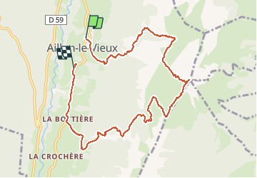
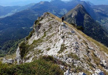
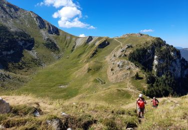
Ruta Senderismo de 10,4 km a descubrir en Auvergne-Rhône-Alpes, Saboya, Aillon-le-Vieux. Esta ruta ha sido propuesta por scalpy.
Descripción
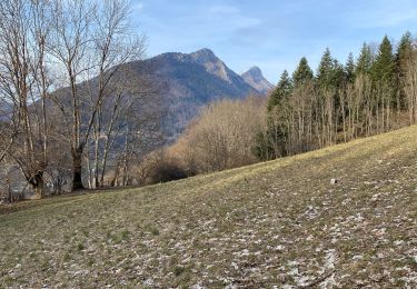
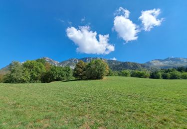
montée raide par la forêt jusqu'à la crête que l'eut jusqu'au sommet. vue magnifique sur.les.bauges et le lac d'annecy ainsi que les alpes.
Localización
País:
France
Región :
Auvergne-Rhône-Alpes
Departamento/provincia :
Saboya
Municipio :
Aillon-le-Vieux
Localidad:
Unknown
Salida:(Dec)
Salida:(UTM)
273635 ; 5059477 (32T) N.
Comentarios
Excursiones cerca
![Excursión Senderismo Aillon-le-Jeune - Bauges le Colombier et des crêtes - Photo](https://media.geolcdn.com/t/375/260/ext.jpg?maxdim=2&url=https%3A%2F%2Fstatic1.geolcdn.com%2Fsiteimages%2Fupload%2Ffiles%2F1553511878bg_sport_marche.png)
![Senderismo Senderismo](https://static1.geolcdn.com/sitytour/trail-icons/101.png)
Bauges le Colombier et des crêtes
Senderismo
Medio
(1)
Aillon-le-Jeune,
Auvergne-Rhône-Alpes,
Saboya,
France
![](/images/other/stat-length.png)
14,2 km | 28 km-effort
5h 35min
![](https://static1.geolcdn.com/siteimages/upload/files/16400158638029165_repeat_loop_refresh_sync_direction_icon.png)
Sí
![Excursión Senderismo Aillon-le-Jeune - Colombier par rocher de la Bade et Cochette, retour par la Fulie - Photo](https://media.geolcdn.com/t/375/260/ext.jpg?maxdim=2&url=https%3A%2F%2Fstatic1.geolcdn.com%2Fsiteimages%2Fupload%2Ffiles%2F1553511878bg_sport_marche.png)
![Senderismo Senderismo](https://static1.geolcdn.com/sitytour/trail-icons/101.png)
Colombier par rocher de la Bade et Cochette, retour par la Fulie
Senderismo
Muy fácil
(2)
Aillon-le-Jeune,
Auvergne-Rhône-Alpes,
Saboya,
France
![](/images/other/stat-length.png)
17,7 km | 35 km-effort
6h 4min
![](https://static1.geolcdn.com/siteimages/upload/files/16400158638029165_repeat_loop_refresh_sync_direction_icon.png)
Sí
![Excursión Senderismo Aillon-le-Jeune - Petit circuit découverte aillon le jeune - Photo](https://media.geolcdn.com/t/375/260/ext.jpg?maxdim=2&url=https%3A%2F%2Fmedia.geolcdn.com%2Ff%2F9feb56d6-5072-42da-bdbc-71a62ee2fe47.jpg)
![Senderismo Senderismo](https://static1.geolcdn.com/sitytour/trail-icons/101.png)
Petit circuit découverte aillon le jeune
Senderismo
Muy fácil
Aillon-le-Jeune,
Auvergne-Rhône-Alpes,
Saboya,
France
![](/images/other/stat-length.png)
5,9 km | 8,9 km-effort
1h 59min
![](https://static1.geolcdn.com/siteimages/upload/files/16400158638029165_repeat_loop_refresh_sync_direction_icon.png)
Sí
![Excursión Senderismo Aillon-le-Vieux - col colombier - Photo](https://media.geolcdn.com/t/375/260/ext.jpg?maxdim=2&url=https%3A%2F%2Fmedia.geolcdn.com%2Ff%2Fe2b5f89d-50b0-4b1d-ae97-04fc8e08fc45.jpg)
![Senderismo Senderismo](https://static1.geolcdn.com/sitytour/trail-icons/101.png)
col colombier
Senderismo
Medio
Aillon-le-Vieux,
Auvergne-Rhône-Alpes,
Saboya,
France
![](/images/other/stat-length.png)
9,4 km | 21 km-effort
3h 5min
![](https://static1.geolcdn.com/siteimages/upload/files/16400158638029165_repeat_loop_refresh_sync_direction_icon.png)
Sí
![Excursión Senderismo Aillon-le-Jeune - 290523 Margeriaz - Photo](https://media.geolcdn.com/t/375/260/ext.jpg?maxdim=2&url=https%3A%2F%2Fmedia.geolcdn.com%2Ff%2F35218944-c7d6-4dd0-99cb-f918606477a9.jpg)
![Senderismo Senderismo](https://static1.geolcdn.com/sitytour/trail-icons/101.png)
290523 Margeriaz
Senderismo
Muy fácil
Aillon-le-Jeune,
Auvergne-Rhône-Alpes,
Saboya,
France
![](/images/other/stat-length.png)
10,3 km | 17,7 km-effort
3h 32min
![](https://static1.geolcdn.com/siteimages/upload/files/16400158638029165_repeat_loop_refresh_sync_direction_icon.png)
Sí
![Excursión Senderismo Le Châtelard - Cascade du Pissieu - Photo](https://media.geolcdn.com/t/375/260/ext.jpg?maxdim=2&url=https%3A%2F%2Fmedia.geolcdn.com%2Ff%2F62ddcacb-da35-460a-889e-e780d98ecafd.jpg)
![Senderismo Senderismo](https://static1.geolcdn.com/sitytour/trail-icons/101.png)
Cascade du Pissieu
Senderismo
Fácil
Le Châtelard,
Auvergne-Rhône-Alpes,
Saboya,
France
![](/images/other/stat-length.png)
3,8 km | 4,8 km-effort
1h 5min
![](https://static1.geolcdn.com/siteimages/upload/files/16400158638029165_repeat_loop_refresh_sync_direction_icon.png)
Sí
![Excursión Senderismo Aillon-le-Jeune - BAUGES: MONT COLOMBIER - Photo](https://media.geolcdn.com/t/375/260/ext.jpg?maxdim=2&url=https%3A%2F%2Fmedia.geolcdn.com%2Ff%2F93784193-f213-453e-8de3-29c6e637b5a3.jpg)
![Senderismo Senderismo](https://static1.geolcdn.com/sitytour/trail-icons/101.png)
BAUGES: MONT COLOMBIER
Senderismo
Difícil
Aillon-le-Jeune,
Auvergne-Rhône-Alpes,
Saboya,
France
![](/images/other/stat-length.png)
10,8 km | 23 km-effort
4h 19min
![](https://static1.geolcdn.com/siteimages/upload/files/16400158638029165_repeat_loop_refresh_sync_direction_icon.png)
Sí
![Excursión Senderismo Saint-François-de-Sales - La Plate_G1 - Photo](https://media.geolcdn.com/t/375/260/ext.jpg?maxdim=2&url=https%3A%2F%2Fstatic1.geolcdn.com%2Fsiteimages%2Fupload%2Ffiles%2F1553511878bg_sport_marche.png)
![Senderismo Senderismo](https://static1.geolcdn.com/sitytour/trail-icons/101.png)
La Plate_G1
Senderismo
Medio
(1)
Saint-François-de-Sales,
Auvergne-Rhône-Alpes,
Saboya,
France
![](/images/other/stat-length.png)
8,7 km | 11,9 km-effort
2h 41min
![](https://static1.geolcdn.com/siteimages/upload/files/16400158638029165_repeat_loop_refresh_sync_direction_icon.png)
Sí
![Excursión Senderismo Aillon-le-Vieux - BAUGES: DENT DE ROSSANAZ - Photo](https://media.geolcdn.com/t/375/260/ext.jpg?maxdim=2&url=https%3A%2F%2Fmedia.geolcdn.com%2Ff%2F8946ba16-85a3-4090-9cd8-9c88fecba28e.jpg)
![Senderismo Senderismo](https://static1.geolcdn.com/sitytour/trail-icons/101.png)
BAUGES: DENT DE ROSSANAZ
Senderismo
Medio
Aillon-le-Vieux,
Auvergne-Rhône-Alpes,
Saboya,
France
![](/images/other/stat-length.png)
11,7 km | 26 km-effort
5h 30min
![](https://static1.geolcdn.com/siteimages/upload/files/16400158638029165_repeat_loop_refresh_sync_direction_icon.png)
Sí