![](/images/other/stat-length.png)
![Excursión Esquí de fondo Laval-en-Belledonne - col du Rafour et couloir ouest de la montagne de Barlet - Photo](https://media.geolcdn.com/t/1900/400/ext.pjpeg?maxdim=2&url=https%3A%2F%2Fmedia.geolcdn.com%2Ff%2F93573ad3-540b-4442-acb2-432d15b1a0ec.jpg)
col du Rafour et couloir ouest de la montagne de Barlet
nadd73
Usuario
![Longitud](/images/other/stat-length.png)
Longitud
10,9 km
![Altitud máxima](https://static1.geolcdn.com/siteimages/upload/files/1508320355ic_sort_altitude_max_24dp.png)
Altitud máxima
2268 m
![Desnivel positivo](https://static1.geolcdn.com/siteimages/upload/files/1508320355ic_sort_den_pos_24dp.png)
Desnivel positivo
1107 m
![Km-Effort](/images/other/stat-length.png)
Km-Effort
26 km
![Altitud mínima](https://static1.geolcdn.com/siteimages/upload/files/1508320355ic_sort_altitude_min_24dp.png)
Altitud mínima
1302 m
![Desnivel negativo](https://static1.geolcdn.com/siteimages/upload/files/1508320355ic_sort_den_neg_24dp.png)
Desnivel negativo
1100 m
![Boucle](https://static1.geolcdn.com/siteimages/upload/files/16400158638029165_repeat_loop_refresh_sync_direction_icon.png)
Boucle
No
Fecha de creación :
2021-02-24 07:10:43.811
Última modificación :
2021-02-24 18:05:25.512
![Esquí de fondo](https://static1.geolcdn.com/sitytour/trail-icons/503.png)
6h29
Dificultad : Difícil
![Escanee este código QR para abrir la excursión en la aplicación SityTrail](https://capi.geolives.com/qq0zvz2zws4bq2lad0pu/sitytour/trails/2683916/qr.png?size=200)
Aplicación GPS de excursión GRATIS
A propósito
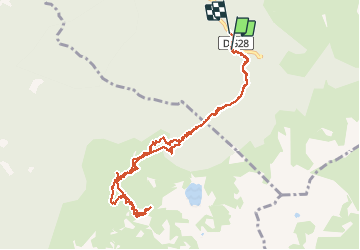
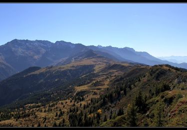
Ruta Esquí de fondo de 10,9 km a descubrir en Auvergne-Rhône-Alpes, Isère, Laval-en-Belledonne. Esta ruta ha sido propuesta por nadd73.
Descripción
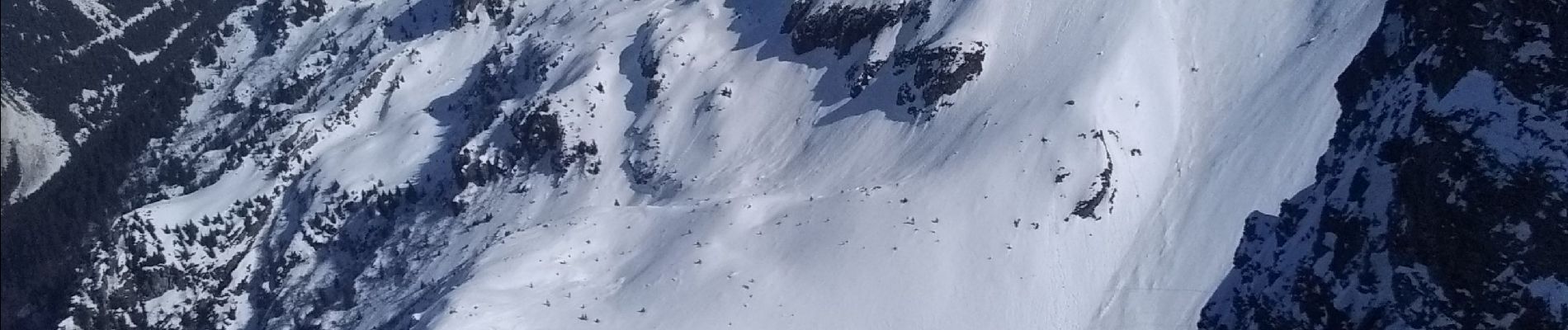
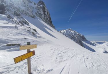
De Prabert pont de la bêta, barrière ouverte car plus de neige sur la route car il fait très chaud.
En bas dans les vernes neige avec des boules et trafolées. Peu de monde de ce côté.
Localización
País:
France
Región :
Auvergne-Rhône-Alpes
Departamento/provincia :
Isère
Municipio :
Laval-en-Belledonne
Localidad:
Unknown
Salida:(Dec)
Salida:(UTM)
735025 ; 5012352 (31T) N.
Comentarios
Excursiones cerca
![Excursión Senderismo Les Adrets - les 7 laux - Photo](https://media.geolcdn.com/t/375/260/ext.jpg?maxdim=2&url=https%3A%2F%2Fservices.sitytrail.com%2FGeolivesWS%2FDownloadMedia.ashx%3FTrailID%3D210621%26Media%3Dfix__20130806134428.jpg)
![Senderismo Senderismo](https://static1.geolcdn.com/sitytour/trail-icons/101.png)
les 7 laux
Senderismo
Medio
(1)
Les Adrets,
Auvergne-Rhône-Alpes,
Isère,
France
![](/images/other/stat-length.png)
12,4 km | 21 km-effort
4h 23min
![](https://static1.geolcdn.com/siteimages/upload/files/16400158638029165_repeat_loop_refresh_sync_direction_icon.png)
Sí
![Excursión Senderismo Laval-en-Belledonne - Boucle Laval - Sainte-Agnès - Photo](https://media.geolcdn.com/t/375/260/ext.jpg?maxdim=2&url=https%3A%2F%2Fmedia.geolcdn.com%2Ff%2F6fb48a75-8298-4bbf-bcc4-cbe453c6b40f.jpg)
![Senderismo Senderismo](https://static1.geolcdn.com/sitytour/trail-icons/101.png)
Boucle Laval - Sainte-Agnès
Senderismo
Medio
Laval-en-Belledonne,
Auvergne-Rhône-Alpes,
Isère,
France
![](/images/other/stat-length.png)
17,7 km | 29 km-effort
4h 28min
![](https://static1.geolcdn.com/siteimages/upload/files/16400158638029165_repeat_loop_refresh_sync_direction_icon.png)
Sí
![Excursión Senderismo Saint-Mury-Monteymond - Lac Blanc au pied de Belledonne - Photo](https://media.geolcdn.com/t/375/260/ext.jpg?maxdim=2&url=https%3A%2F%2Fmedia.geolcdn.com%2Ff%2Fbe8bcf54-d056-4226-93e0-f27b8cc25845.jpg)
![Senderismo Senderismo](https://static1.geolcdn.com/sitytour/trail-icons/101.png)
Lac Blanc au pied de Belledonne
Senderismo
Muy difícil
Saint-Mury-Monteymond,
Auvergne-Rhône-Alpes,
Isère,
France
![](/images/other/stat-length.png)
12,2 km | 26 km-effort
5h 49min
![](https://static1.geolcdn.com/siteimages/upload/files/16400158638029165_repeat_loop_refresh_sync_direction_icon.png)
Sí
![Excursión Senderismo Theys - Col du Merdaret, Roche Noire au départ de Pipay - Photo](https://media.geolcdn.com/t/375/260/ext.jpg?maxdim=2&url=https%3A%2F%2Fmedia.geolcdn.com%2Ff%2Fe8517cd9-feda-4b9d-af2b-666d1f82fbe9.jpg)
![Senderismo Senderismo](https://static1.geolcdn.com/sitytour/trail-icons/101.png)
Col du Merdaret, Roche Noire au départ de Pipay
Senderismo
Fácil
Theys,
Auvergne-Rhône-Alpes,
Isère,
France
![](/images/other/stat-length.png)
14,2 km | 24 km-effort
4h 15min
![](https://static1.geolcdn.com/siteimages/upload/files/16400158638029165_repeat_loop_refresh_sync_direction_icon.png)
Sí
![Excursión Senderismo Saint-Mury-Monteymond - Col et Pointe de la Sitre - Photo](https://media.geolcdn.com/t/375/260/ext.jpg?maxdim=2&url=https%3A%2F%2Fmedia.geolcdn.com%2Ff%2F12aa835d-a61b-4dc5-8899-8748a81192a8.jpg)
![Senderismo Senderismo](https://static1.geolcdn.com/sitytour/trail-icons/101.png)
Col et Pointe de la Sitre
Senderismo
Muy difícil
Saint-Mury-Monteymond,
Auvergne-Rhône-Alpes,
Isère,
France
![](/images/other/stat-length.png)
11,2 km | 23 km-effort
5h 14min
![](https://static1.geolcdn.com/siteimages/upload/files/16400158638029165_repeat_loop_refresh_sync_direction_icon.png)
Sí
![Excursión Senderismo Laval-en-Belledonne - Tour du vallon de Laval - Photo](https://media.geolcdn.com/t/375/260/ext.jpg?maxdim=2&url=https%3A%2F%2Fmedia.geolcdn.com%2Ff%2Fa31847b6-2af2-41ec-ac8f-7d673e513f01.jpg)
![Senderismo Senderismo](https://static1.geolcdn.com/sitytour/trail-icons/101.png)
Tour du vallon de Laval
Senderismo
Medio
Laval-en-Belledonne,
Auvergne-Rhône-Alpes,
Isère,
France
![](/images/other/stat-length.png)
13,5 km | 21 km-effort
4h 38min
![](https://static1.geolcdn.com/siteimages/upload/files/16400158638029165_repeat_loop_refresh_sync_direction_icon.png)
Sí
![Excursión Esquí de fondo Allemond - Brèche de la Roche fendue Est - Photo](https://media.geolcdn.com/t/375/260/ext.jpg?maxdim=2&url=https%3A%2F%2Fmedia.geolcdn.com%2Ff%2Fbd941ed5-0da8-45b1-ac18-9f9f2876afc2.jpg)
![Esquí de fondo Esquí de fondo](https://static1.geolcdn.com/sitytour/trail-icons/503.png)
Brèche de la Roche fendue Est
Esquí de fondo
Medio
Allemond,
Auvergne-Rhône-Alpes,
Isère,
France
![](/images/other/stat-length.png)
10 km | 26 km-effort
3h 47min
![](https://static1.geolcdn.com/siteimages/upload/files/16400158638029165_repeat_loop_refresh_sync_direction_icon.png)
Sí
![Excursión Senderismo Theys - Grand Rocher - Photo](https://media.geolcdn.com/t/375/260/ext.jpg?maxdim=2&url=https%3A%2F%2Fmedia.geolcdn.com%2Ff%2Fc497a342-e6f3-477c-a675-f192c571400d.jpg)
![Senderismo Senderismo](https://static1.geolcdn.com/sitytour/trail-icons/101.png)
Grand Rocher
Senderismo
Medio
Theys,
Auvergne-Rhône-Alpes,
Isère,
France
![](/images/other/stat-length.png)
15,2 km | 24 km-effort
4h 40min
![](https://static1.geolcdn.com/siteimages/upload/files/16400158638029165_repeat_loop_refresh_sync_direction_icon.png)
Sí
![Excursión Senderismo Laval-en-Belledonne - boucle lac de croq col de la mine de fer - Photo](https://media.geolcdn.com/t/375/260/ext.jpg?maxdim=2&url=https%3A%2F%2Fmedia.geolcdn.com%2Ff%2Fcbfe70e6-252d-41e3-929b-6ba3913a2ad8.jpg)
![Senderismo Senderismo](https://static1.geolcdn.com/sitytour/trail-icons/101.png)
boucle lac de croq col de la mine de fer
Senderismo
Medio
Laval-en-Belledonne,
Auvergne-Rhône-Alpes,
Isère,
France
![](/images/other/stat-length.png)
16,4 km | 35 km-effort
6h 40min
![](https://static1.geolcdn.com/siteimages/upload/files/16400158638029165_repeat_loop_refresh_sync_direction_icon.png)
Sí