Excursión Bici de montaña Staphorst - Overijssel - Vaste MTBroute Staphorst - Photo

Overijssel - Vaste MTBroute Staphorst

 gpstracks
gpstracks

Usuario

© OpenStreetMap contributors
Longitud
Longitud
16,7 km
Altitud máxima
Altitud máxima
18 m
Desnivel positivo
Desnivel positivo
125 m
Km-Effort
Km-Effort  
18,3 km
Altitud mínima
Altitud mínima
2 m
Desnivel negativo
Desnivel negativo
125 m
Boucle
Boucle
Fecha de creación :
2014-12-10 00:00:00.0
Última modificación :
2014-12-10 00:00:00.0

(0 Opinión)

Bici de montaña
Bici de montaña
--
Dificultad : Desconocido

Escanee este código QR para abrir la excursión en la aplicación SityTrail

Aplicación GPS de excursión GRATIS

Logo SityTrail SityTrail

IGN / Institutos geográficos

Descargar SityTrail en App Store Descargar SityTrail en Google Play

Logo SityTrail SityTrail World

El mundo es suyo

Descargar SityTrail en App Store Descargar SityTrail en Google Play Descargar SityTrail en Huawei AppGallery

A propósito

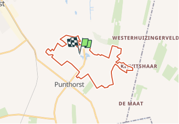
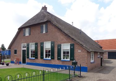
Ruta Bici de montaña de 16,7 km a descubrir en Overijssel, Desconocido, Staphorst. Esta ruta ha sido propuesta por gpstracks.

Descripción

More information on GPStracks.nl : http://www.gpstracks.nl

Perfil altimétrico

Puntos de interés

Punto de interés Staphorst - START - Photo
gpstracks
STAPHORST 

Localización

País:
Netherlands
Región :
Overijssel
Departamento/provincia :
Desconocido
Municipio :
Staphorst
Localidad:
Unknown
Salida:(Dec)
Salida:(UTM)
315295 ; 5834143 (32U) N.

Excursiones cerca

Excursión A pie Staphorst - Kuierpad IJhorst bruin - Photo
A pie
PRO

A pie

Fácil
Staphorst, Overijssel, Desconocido, Netherlands
5,5 km | 6 km-effort
1h 22min
Excursión A pie Staphorst - WNW Vechtdal -Staphorst - oranje route - Photo
A pie
PRO

A pie

Fácil
Staphorst, Overijssel, Desconocido, Netherlands
3,4 km | 3,5 km-effort
47min
Excursión A pie Staphorst - WNW Vechtdal - Staphorst - rode route - Photo
A pie
PRO

A pie

Fácil
Staphorst, Overijssel, Desconocido, Netherlands
10,3 km | 10,6 km-effort
2h 24min
Excursión A pie Staphorst - WNW Vechtdal -Staphorst - groene route - Photo
A pie
PRO

A pie

Fácil
Staphorst, Overijssel, Desconocido, Netherlands
14,7 km | 15,3 km-effort
3h 28min
Excursión A pie Staphorst - WNW Vechtdal -Staphorst - gele route - Photo
A pie
PRO

A pie

Fácil
Staphorst, Overijssel, Desconocido, Netherlands
8,5 km | 9 km-effort
2h 2min
Excursión A pie Staphorst - WNW Vechtdal - Zwarte Venen - paarse route - Photo
A pie
PRO

A pie

Fácil
Staphorst, Overijssel, Desconocido, Netherlands
3,6 km | 3,7 km-effort
50min
No
Excursión A pie Ommen - WNW Vechtdal - verbinding V20-V21-V23-V32 - Photo
A pie
PRO

A pie

Fácil
Ommen, Overijssel, Desconocido, Netherlands
7,2 km | 7,5 km-effort
1h 42min
No
Excursión A pie Staphorst - WNW Vechtdal - verbinding Z48-Z54 - Photo
A pie
PRO

A pie

Fácil
Staphorst, Overijssel, Desconocido, Netherlands
6,1 km | 6,3 km-effort
1h 26min
No
Excursión Motor Staphorst - a-drenthe-meeting-noord - Photo
Motor
gpstracks

Motor

Muy fácil
Staphorst, Overijssel, Desconocido, Netherlands
50 km | 53 km-effort
Desconocido
No


Cerrar
Mis suscripciones