![](/images/other/stat-length.png)
![Excursión Senderismo Notre-Dame-de-Bondeville - Allée des Orchies- ND Bondeville- Le Houlme - Photo](https://media.geolcdn.com/t/1900/400/ext.pjpeg?maxdim=2&url=https%3A%2F%2Fmedia.geolcdn.com%2Ff%2F13108c00-267a-4d45-8a90-4d680173892e.jpg)
Allée des Orchies- ND Bondeville- Le Houlme
jacques delaporte
Usuario
![Longitud](/images/other/stat-length.png)
Longitud
23 km
![Altitud máxima](https://static1.geolcdn.com/siteimages/upload/files/1508320355ic_sort_altitude_max_24dp.png)
Altitud máxima
172 m
![Desnivel positivo](https://static1.geolcdn.com/siteimages/upload/files/1508320355ic_sort_den_pos_24dp.png)
Desnivel positivo
532 m
![Km-Effort](/images/other/stat-length.png)
Km-Effort
30 km
![Altitud mínima](https://static1.geolcdn.com/siteimages/upload/files/1508320355ic_sort_altitude_min_24dp.png)
Altitud mínima
20 m
![Desnivel negativo](https://static1.geolcdn.com/siteimages/upload/files/1508320355ic_sort_den_neg_24dp.png)
Desnivel negativo
532 m
![Boucle](https://static1.geolcdn.com/siteimages/upload/files/16400158638029165_repeat_loop_refresh_sync_direction_icon.png)
Boucle
Sí
Fecha de creación :
2022-03-03 12:21:01.314
Última modificación :
2022-03-03 17:04:52.756
![Senderismo](https://static1.geolcdn.com/sitytour/trail-icons/101.png)
4h43
Dificultad : Fácil
![Escanee este código QR para abrir la excursión en la aplicación SityTrail](https://capi.geolives.com/qq0zvz2zws4bq2lad0pu/sitytour/trails/3153801/qr.png?size=200)
Aplicación GPS de excursión GRATIS
A propósito
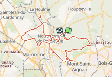
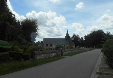
Ruta Senderismo de 23 km a descubrir en Normandía, Sena-Marítimo, Notre-Dame-de-Bondeville. Esta ruta ha sido propuesta por jacques delaporte.
Descripción
Belle randonnée hivernale,sensibles au Macadam, s'abstenir et agréable douceur Normande
Localización
País:
France
Región :
Normandía
Departamento/provincia :
Sena-Marítimo
Municipio :
Notre-Dame-de-Bondeville
Localidad:
Unknown
Salida:(Dec)
Salida:(UTM)
359826 ; 5483627 (31U) N.
Comentarios
Excursiones cerca
![Excursión Senderismo Mont-Saint-Aignan - Mont-saint-aignan - Chasse-Marée - - Photo](https://media.geolcdn.com/t/375/260/ext.jpg?maxdim=2&url=https%3A%2F%2Fmedia.geolcdn.com%2Ff%2F9cf681a4-2bd4-44f5-95c9-4e27e69bf20e.jpg)
![Senderismo Senderismo](https://static1.geolcdn.com/sitytour/trail-icons/101.png)
Mont-saint-aignan - Chasse-Marée -
Senderismo
Difícil
(1)
Mont-Saint-Aignan,
Normandía,
Sena-Marítimo,
France
![](/images/other/stat-length.png)
11,7 km | 15,2 km-effort
3h 27min
![](https://static1.geolcdn.com/siteimages/upload/files/16400158638029165_repeat_loop_refresh_sync_direction_icon.png)
Sí
![Excursión Senderismo Le Houlme - 076-65-le Houlme Malaunay Canicule 9km - Photo](https://media.geolcdn.com/t/375/260/ext.jpg?maxdim=2&url=https%3A%2F%2Fmedia.geolcdn.com%2Ff%2Fcf5018c2-c685-4aa8-b115-bf28ee60bc47.jpg)
![Senderismo Senderismo](https://static1.geolcdn.com/sitytour/trail-icons/101.png)
076-65-le Houlme Malaunay Canicule 9km
Senderismo
Medio
(1)
Le Houlme,
Normandía,
Sena-Marítimo,
France
![](/images/other/stat-length.png)
10 km | 13,7 km-effort
2h 56min
![](https://static1.geolcdn.com/siteimages/upload/files/16400158638029165_repeat_loop_refresh_sync_direction_icon.png)
Sí
![Excursión Senderismo Canteleu - Canteleu - Montigny - GD - Photo](https://media.geolcdn.com/t/375/260/ext.jpg?maxdim=2&url=https%3A%2F%2Fstatic1.geolcdn.com%2Fsiteimages%2Fupload%2Ffiles%2F1553511878bg_sport_marche.png)
![Senderismo Senderismo](https://static1.geolcdn.com/sitytour/trail-icons/101.png)
Canteleu - Montigny - GD
Senderismo
Difícil
(1)
Canteleu,
Normandía,
Sena-Marítimo,
France
![](/images/other/stat-length.png)
11,4 km | 13,3 km-effort
3h 0min
![](https://static1.geolcdn.com/siteimages/upload/files/16400158638029165_repeat_loop_refresh_sync_direction_icon.png)
Sí
![Excursión Bici de montaña Canteleu - Randonnée VTT Oxibike 2011 Canteleu 40 Kms - Photo](https://media.geolcdn.com/t/375/260/ext.jpg?maxdim=2&url=https%3A%2F%2Fstatic1.geolcdn.com%2Fsiteimages%2Fupload%2Ffiles%2F1524743154velo.jpg)
![Bici de montaña Bici de montaña](https://static1.geolcdn.com/sitytour/trail-icons/202.png)
Randonnée VTT Oxibike 2011 Canteleu 40 Kms
Bici de montaña
Difícil
(1)
Canteleu,
Normandía,
Sena-Marítimo,
France
![](/images/other/stat-length.png)
40 km | 49 km-effort
3h 0min
![](https://static1.geolcdn.com/siteimages/upload/files/16400158638029165_repeat_loop_refresh_sync_direction_icon.png)
Sí
![Excursión Senderismo Le Houlme - 20231026-Le Houlme - Photo](https://media.geolcdn.com/t/375/260/ext.jpg?maxdim=2&url=https%3A%2F%2Fmedia.geolcdn.com%2Ff%2Faac14a0f-ce89-4df3-897e-c02ee56fc067.JPG)
![Senderismo Senderismo](https://static1.geolcdn.com/sitytour/trail-icons/101.png)
20231026-Le Houlme
Senderismo
Medio
Le Houlme,
Normandía,
Sena-Marítimo,
France
![](/images/other/stat-length.png)
12 km | 15,7 km-effort
3h 29min
![](https://static1.geolcdn.com/siteimages/upload/files/16400158638029165_repeat_loop_refresh_sync_direction_icon.png)
Sí
![Excursión Marcha nórdica Bois-Guillaume - MN - Bois-Guillaume - Bretèque - Photo](https://media.geolcdn.com/t/375/260/ext.jpg?maxdim=2&url=https%3A%2F%2Fstatic1.geolcdn.com%2Fsiteimages%2Fupload%2Ffiles%2F1545311037marcheuse_200dpi.jpg)
![Marcha nórdica Marcha nórdica](https://static1.geolcdn.com/sitytour/trail-icons/102.png)
MN - Bois-Guillaume - Bretèque
Marcha nórdica
Muy fácil
(1)
Bois-Guillaume,
Normandía,
Sena-Marítimo,
France
![](/images/other/stat-length.png)
6,9 km | 7,9 km-effort
1h 15min
![](https://static1.geolcdn.com/siteimages/upload/files/16400158638029165_repeat_loop_refresh_sync_direction_icon.png)
Sí
![Excursión Senderismo Houppeville - 2023-09-09_18h54m19_activity_la_breteque_2VAUbDmYip1bXIXdp2Rh75Nga7h - Photo](https://media.geolcdn.com/t/375/260/ext.jpg?maxdim=2&url=https%3A%2F%2Fmedia.geolcdn.com%2Ff%2F340fcb56-707e-4cbf-b785-2c8b5ef4c392.JPG)
![Senderismo Senderismo](https://static1.geolcdn.com/sitytour/trail-icons/101.png)
2023-09-09_18h54m19_activity_la_breteque_2VAUbDmYip1bXIXdp2Rh75Nga7h
Senderismo
Difícil
Houppeville,
Normandía,
Sena-Marítimo,
France
![](/images/other/stat-length.png)
11,3 km | 14,4 km-effort
3h 16min
![](https://static1.geolcdn.com/siteimages/upload/files/16400158638029165_repeat_loop_refresh_sync_direction_icon.png)
Sí
![Excursión Senderismo Déville-lès-Rouen - 20230829-Déville les Rouen - Photo](https://media.geolcdn.com/t/375/260/ext.jpg?maxdim=2&url=https%3A%2F%2Fmedia.geolcdn.com%2Ff%2Fa1bfb1dc-651d-48f6-b3a4-c9672c17c4e9.JPG)
![Senderismo Senderismo](https://static1.geolcdn.com/sitytour/trail-icons/101.png)
20230829-Déville les Rouen
Senderismo
Medio
Déville-lès-Rouen,
Normandía,
Sena-Marítimo,
France
![](/images/other/stat-length.png)
11,9 km | 16,3 km-effort
3h 38min
![](https://static1.geolcdn.com/siteimages/upload/files/16400158638029165_repeat_loop_refresh_sync_direction_icon.png)
Sí
![Excursión Senderismo Montigny - 20230711-Montigny - Photo](https://media.geolcdn.com/t/375/260/ext.jpg?maxdim=2&url=https%3A%2F%2Fmedia.geolcdn.com%2Ff%2F68aaf26a-a37f-405f-8dc9-706c75df9396.JPG)
![Senderismo Senderismo](https://static1.geolcdn.com/sitytour/trail-icons/101.png)
20230711-Montigny
Senderismo
Medio
Montigny,
Normandía,
Sena-Marítimo,
France
![](/images/other/stat-length.png)
12,4 km | 16,2 km-effort
3h 37min
![](https://static1.geolcdn.com/siteimages/upload/files/16400158638029165_repeat_loop_refresh_sync_direction_icon.png)
Sí