Excursión Senderismo Tellin - Bure - Le chemin des Bruyères - Photo

Bure - Le chemin des Bruyères

Randonnées de la Grande Forêt de Saint-Hubert GUIDE+

© OpenStreetMap contributors
Longitud
Longitud
8,1 km
Altitud máxima
Altitud máxima
307 m
Desnivel positivo
Desnivel positivo
138 m
Km-Effort
Km-Effort  
9,9 km
Altitud mínima
Altitud mínima
240 m
Desnivel negativo
Desnivel negativo
139 m
Boucle
Boucle
Baliza
Baliza
Fecha de creación :
2017-10-30 00:00:00.0
Última modificación :
2017-10-30 00:00:00.0

(3 Opinión)

Senderismo
Senderismo
2h09
Dificultad : Medio

Escanee este código QR para abrir la excursión en la aplicación SityTrail

Aplicación GPS de excursión GRATIS

Logo SityTrail SityTrail

IGN / Institutos geográficos

Descargar SityTrail en App Store Descargar SityTrail en Google Play

Logo SityTrail SityTrail World

El mundo es suyo

Descargar SityTrail en App Store Descargar SityTrail en Google Play Descargar SityTrail en Huawei AppGallery

A propósito

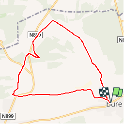
Ruta Senderismo de 8,1 km a descubrir en Valonia, Luxemburgo, Tellin. Esta ruta ha sido propuesta por La Grande Forêt de Saint-Hubert.

Descripción

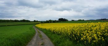
The Chemin des Bruyères wears well its name! Indeed, besides the remarkable building that can be seen in the heart of Bure, this commune reveals a natural heritage admirable.
There are many floral species along the Chemin des Bruyères, which reveal a superb west-north-west point of view, on the surrounding countryside, up to the Lesse valley.
Here you will find the Champ des Bœufs, covered with small rhinanths and centaurées from there, the site of Maralles. This wetland, dominated by rock outcrops, is bordered by thorny bushes such as hawthorn and blackthorn, and a wide variety of plant species including reflected orbit, acrid root, winged broom, Serpole, cornflower and yellow helianthemum, which will delight botanists and the happiness of the uninitiated.
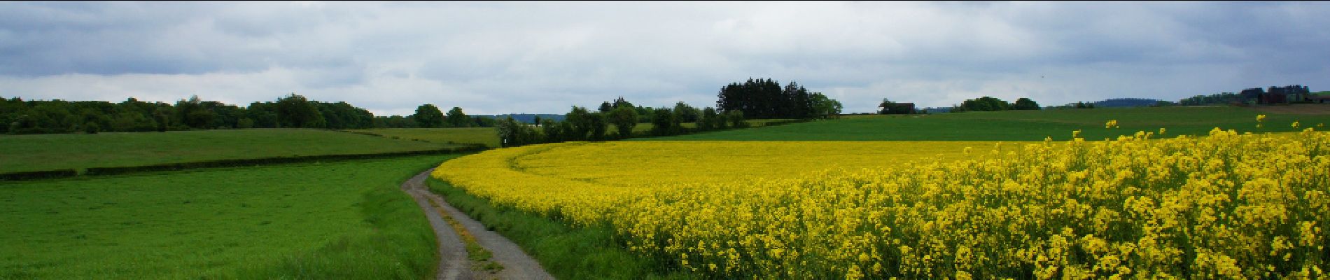
The locality Bottle, offers a vast panorama on the Ardennes promontory south-southwest and closer, on the calcareous plain mainly cultivated of cereals.
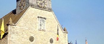
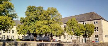
On your way back, you can admire the old castle of Bure, which now houses the Collège d'Alzon, before joining the Saint Lambert church. This classic style construction made of limestone and sandstone has a beveled base. The key to the portal dates from 1738. The presbytery dates back to the second half of the 18th century.
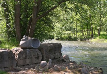
Not far from there is the royal fountain, equipped with a cast iron pump dating from the 19th century with a limestone drinking trough. Discover other fountains in the village. Some of them remain in the Rue de Mirwart (in front of No. 21), Rue de Grupont (opposite No. 21) and Rue de Tellin (facing No. 4 and 16).

Perfil altimétrico

Fotos

Puntos de interés

Punto de interés Tellin - Bure - Chemin des Bruyères - Photo
La Grande Forêt de Saint-Hubert
Punto de interés Tellin - Bure - Church Sint-Lambert - Photo
La Grande Forêt de Saint-Hubert
Punto de interés Tellin - Collège d'Alzon or The old Castle - Photo
La Grande Forêt de Saint-Hubert
Punto de interés Tellin - Location village of Tellin - Photo
La Grande Forêt de Saint-Hubert
Punto de interés Tellin - Coray Farm - Photo
La Grande Forêt de Saint-Hubert
TELLIN 

Localización

País:
Belgium
Región :
Valonia
Departamento/provincia :
Luxemburgo
Municipio :
Tellin
Localidad:
Bure
Salida:(Dec)
Salida:(UTM)
661663 ; 5550944 (31U) N.

Comentarios

Por favor conéctese para dejar un comentario o una evaluación


Promenade facile, bien dégagée, quelques belles vues, très bien balisée. Un peu morne en hiver, à revoir au printemps. On croise et côtoye un peu trop les routes à circulation.


Promenade facile, bien dégagée, quelques belles vues, très bien balisée. Un peu morne en hiver, à revoir au printemps. On croise et côtoye un peu trop les routes à circulation.


Excursiones cerca

Excursión Senderismo Tellin - Tellin. Natura 2000, des sites qui valent le détour ! Lx 7 - Photo
Senderismo
GUIDE+

Senderismo

Medio
(6)
Tellin, Valonia, Luxemburgo, Belgium
9,6 km | 11,9 km-effort
1h 30min
Excursión Senderismo Saint-Hubert - Mirwart_Vieux Moulin de Mirwart_Alternative Forêt (SH29 bis) - Photo
Senderismo
GUIDE+

Senderismo

Difícil
(11)
Saint-Hubert, Valonia, Luxemburgo, Belgium
10,8 km | 14,2 km-effort
3h 4min
Excursión Senderismo Rochefort - Nature : Belvaux -Les Rouges-Gorges (the robins) - Photo
Senderismo
PRO

Senderismo

Fácil
(8)
Rochefort, Valonia, Namur, Belgium
6,5 km | 8,4 km-effort
1h 20min
Excursión Senderismo Rochefort - Nature : Belvaux -Les Rouges-Gorges (the robins) - Photo
Senderismo
PRO

Senderismo

Fácil
(13)
Rochefort, Valonia, Namur, Belgium
5,8 km | 7,6 km-effort
1h 20min
Excursión Senderismo Tellin - GG-Lu-13_Grupont - Poix-Saint-Hubert - Photo
Senderismo
PRO

Senderismo

Muy difícil
(2)
Tellin, Valonia, Luxemburgo, Belgium
26 km | 34 km-effort
7h 23min
No
Excursión Senderismo Tellin - Balade à Grupont - Photo
Senderismo
GUIDE
Desrumaux

Senderismo

Fácil
(1)
Tellin, Valonia, Luxemburgo, Belgium
8,4 km | 11,9 km-effort
2h 33min
Excursión Senderismo Rochefort - Nature : Belvaux -Les Rouges-Gorges (the robins) - Photo
Senderismo
PRO

Senderismo

Fácil
(3)
Rochefort, Valonia, Namur, Belgium
5,8 km | 7,6 km-effort
1h 20min
Excursión Senderismo Tellin - Bure - Promenade des chapelles - Photo
Senderismo
GUIDE+

Senderismo

Fácil
(1)
Tellin, Valonia, Luxemburgo, Belgium
4,5 km | 5,9 km-effort
1h 15min
Excursión Senderismo Tellin - Tellin - Promenade du trou des Lûtons  - Photo
Senderismo
GUIDE+

Senderismo

Fácil
(1)
Tellin, Valonia, Luxemburgo, Belgium
5,2 km | 6,1 km-effort
1h 21min


Cerrar
Mis suscripciones