Excursión Senderismo Tellin - Tellin - Promenade de la Croix Javalle - Photo

Tellin - Promenade de la Croix Javalle

Randonnées de la Grande Forêt de Saint-Hubert GUIDE+

© OpenStreetMap contributors
Longitud
Longitud
12,5 km
Altitud máxima
Altitud máxima
401 m
Desnivel positivo
Desnivel positivo
374 m
Km-Effort
Km-Effort  
17,4 km
Altitud mínima
Altitud mínima
245 m
Desnivel negativo
Desnivel negativo
374 m
Boucle
Boucle
Baliza
Baliza
Fecha de creación :
2017-10-30 00:00:00.0
Última modificación :
2017-10-30 00:00:00.0

(1 Opinión)

Senderismo
Senderismo
3h38
Dificultad : Difícil

Escanee este código QR para abrir la excursión en la aplicación SityTrail

Aplicación GPS de excursión GRATIS

Logo SityTrail SityTrail

IGN / Institutos geográficos

Descargar SityTrail en App Store Descargar SityTrail en Google Play

Logo SityTrail SityTrail World

El mundo es suyo

Descargar SityTrail en App Store Descargar SityTrail en Google Play Descargar SityTrail en Huawei AppGallery

A propósito

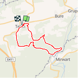
Ruta Senderismo de 12,5 km a descubrir en Valonia, Luxemburgo, Tellin. Esta ruta ha sido propuesta por La Grande Forêt de Saint-Hubert.

Descripción

Whatever your mode of travel, this walk will fill you with the variety of landscapes encountered along the small country roads and forest roads.
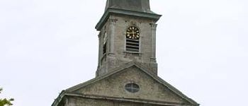
The parish church Saint Lambert is a beautiful neoclassical building built between 1829 and 1832 by the architect Cauchet. A tower was added around 1878 by the architect Bouvrie. The bulbous bell tower is pierced with two-part shocks. A cross punctuates its top.
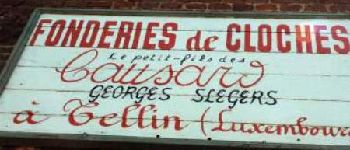
Do not hesitate to linger more in the village of Tellin. Besides its beautiful church, many farms and houses have remarkable architecture.
On the heights of the village, the site of the Cross Javalle hosts several remarkable plant species, such as red fescue, bulbous buttercup, mauve musk and centaury. From here you take the Chemin des Crêtes. Leaving this wooded road, you penetrate further into the forest.
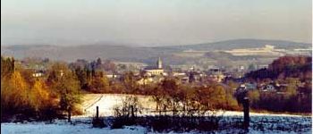
However, in a gap, a remarkable point of view emerges on the village and the castle of Mirwart.
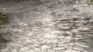
The Ry des Revoz is a moist muddy soil with sphagnum, ranunculus and angelica. A pretty little stream follows its course peacefully in the middle of these species. On discovering the Route des Crêtes, you will discover a wide landscape on the Famenne. In the place called Tasseret, several remarkable species populate the wooded area. In the herbaceous zone, a nice clearance allows to see the village of Tellin and the famennoise campaign. Perhaps you will have the opportunity to cross a fox, which makes frequent appearances on this site.

Perfil altimétrico

Fotos

Puntos de interés

Punto de interés Tellin - Office du tourisme communal de Tellin - Photo
La Grande Forêt de Saint-Hubert
Punto de interés Tellin - Restaurant Le Campagnard - Photo
La Grande Forêt de Saint-Hubert
Punto de interés Tellin -  Saint-Lambert Church of Tellin - Photo
La Grande Forêt de Saint-Hubert
Punto de interés Tellin -  The Foundry of Bells of Tellin - Photo
La Grande Forêt de Saint-Hubert
Punto de interés Tellin - The village of Tellin - Photo
La Grande Forêt de Saint-Hubert

Localización

País:
Belgium
Región :
Valonia
Departamento/provincia :
Luxemburgo
Municipio :
Tellin
Localidad:
Tellin
Salida:(Dec)
Salida:(UTM)
658776 ; 5550049 (31U) N.

Comentarios

Por favor conéctese para dejar un comentario o una evaluación


Excursiones cerca

Excursión Senderismo Rochefort - Nature - The view from the Belvédère in Han-sur-Lesse - Photo
Senderismo
PRO

Senderismo

Difícil
(16)
Rochefort, Valonia, Namur, Belgium
4,8 km | 6,3 km-effort
1h 20min
Excursión Senderismo Tellin - Tellin. Natura 2000, des sites qui valent le détour ! Lx 7 - Photo
Senderismo
GUIDE+

Senderismo

Medio
(6)
Tellin, Valonia, Luxemburgo, Belgium
9,6 km | 11,9 km-effort
1h 30min
Excursión Senderismo Saint-Hubert - Mirwart_Vieux Moulin de Mirwart_Alternative Forêt (SH29 bis) - Photo
Senderismo
GUIDE+

Senderismo

Difícil
(11)
Saint-Hubert, Valonia, Luxemburgo, Belgium
10,8 km | 14,2 km-effort
3h 4min
Excursión Senderismo Rochefort - Nature : Belvaux -Les Rouges-Gorges (the robins) - Photo
Senderismo
PRO

Senderismo

Fácil
(8)
Rochefort, Valonia, Namur, Belgium
6,5 km | 8,4 km-effort
1h 20min
Excursión Senderismo Rochefort - Nature : Belvaux -Les Rouges-Gorges (the robins) - Photo
Senderismo
PRO

Senderismo

Fácil
(13)
Rochefort, Valonia, Namur, Belgium
5,8 km | 7,6 km-effort
1h 20min
Excursión Senderismo Rochefort - Nature - A discovery trail through Han-sur-Lesse - Photo
Senderismo
PRO

Senderismo

Muy fácil
(15)
Rochefort, Valonia, Namur, Belgium
4,8 km | 5,8 km-effort
1h 15min
Excursión Senderismo Tellin - GG-Lu-13_Grupont - Poix-Saint-Hubert - Photo
Senderismo
PRO

Senderismo

Muy difícil
(2)
Tellin, Valonia, Luxemburgo, Belgium
26 km | 34 km-effort
7h 23min
No
Excursión Senderismo Tellin - Balade à Grupont - Photo
Senderismo
GUIDE
Desrumaux

Senderismo

Fácil
(1)
Tellin, Valonia, Luxemburgo, Belgium
8,4 km | 11,9 km-effort
2h 33min
Excursión Senderismo Tellin - Balade à Resteigne - Photo
Senderismo
GUIDE
Desrumaux

Senderismo

Fácil
(1)
Tellin, Valonia, Luxemburgo, Belgium
12,6 km | 16,2 km-effort
3h 32min


Cerrar
Mis suscripciones