


11,4 km | 15,4 km-effort
Aachen-Mitte : découvrez les meilleures randonnées : 50 pédestres et 19 à vélo ou VTT. Tous ces circuits, parcours, itinéraires et activités en plein air sont disponibles dans nos applications SityTrail pour smartphones et tablettes.
Marche


• ℹ www.aachen.de/wandern 📌🅿️ Lütticher Strabe 340 ➡️ Points-noeuds 16 14 65 64 63 62 61 60 51 48 45 44 55 15 16.
Marche
• ℹ www.aachen.de/wandern 📌 🅿️ Köpfchen, Eupener Strabe. ➡️ Points-noeuds 59 58 70 71 72 75 78 79 80 81 35 38 26 70 ...
Marche
• 📍 & 🅿️ Lütticher Strabe 340 ➡️ Points-noeuds 16 17 67 68 46 77 25 26 10 9 ... vers le centre et retour ... 4 5 6 ...
A pied
• Arbeitsgruppe Wanderwege: Die unmittelbare Umgebung des Ortsteils für Wanderer zu erschließen, auszugestalten und mit...
A pied
• Randonnée créée par Stadt Aachen, Fachbereich Umwelt und Fachbereich Stadtentwicklung und Verkehrsanlagen. weiter na...
A pied
• Randonnée créée par Stadt Aachen, Fachbereich Umwelt und Fachbereich Stadtentwicklung und Verkehrsanlagen.
A pied
• Randonnée créée par Stadt Aachen, Fachbereich Umwelt und Fachbereich Stadtentwicklung und Verkehrsanlagen.
A pied
• Randonnée créée par Stadt Aachen, Fachbereich Stadtentwicklung und Verkehrsanlagen; Stadt Herzogenrath, Fachbereich S...
A pied
• Randonnée créée par Stadt Aachen, Fachbereich Umwelt und Fachbereich Stadtentwicklung und Verkehrsanlagen. Site we...
A pied
• Randonnée créée par Stadt Aachen, Fachbereich Umwelt und Fachbereich Stadtentwicklung und Verkehrsanlagen. Site we...
Marche
A pied
A pied
A pied
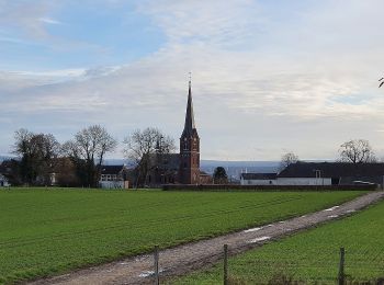
![Randonnée A pied Aix-la-Chapelle - [B4] Aachen Hauptbahnhof nach Brand - Photo](https://media.geolcdn.com/t/350/260/ext.jpg?maxdim=2&url=https%3A%2F%2Fmedia.geolcdn.com%2Ff%2Fe83256ca-dc38-4ff1-a908-0baf40b53d68.jpeg)
A pied
V.T.T.
• Super parcours de vrai VTT. Quelques racines n'ont pas plus à tout le monde...

Marche
• Départ point-noeud n° 8.
Marche
• #combirandoetmarchédeNoël
Marche
• Une randonnée transfrontalière 🇩🇪🇧🇪. ℹ www.aachen.de/wandern 📌🅿️ Köpfchen, Eupener Strabe ➡️ Points-noeuds 59 5...
A pied
20 randonnées affichées sur 70
Application GPS de randonnée GRATUITE
 SityTrail
IGN / Instituts géographiques
SityTrail World
Le monde est à vous