![](/images/other/stat-length.png)
![Randonnée Marche Berdorf - MÜLLERTHAL ( Bisdorff) - Photo](https://media.geolcdn.com/t/1900/400/ext.pjpeg?maxdim=2&url=https%3A%2F%2Fservices.sitytrail.com%2FGeolivesWS%2FDownloadMedia.ashx%3FTrailID%3D816550%26Media%3Dfix__20170824155019.jpg)
MÜLLERTHAL ( Bisdorff)
henrineupre
Utilisateur
![Longueur](/images/other/stat-length.png)
Longueur
7,1 km
![Altitude max](https://static1.geolcdn.com/siteimages/upload/files/1508320355ic_sort_altitude_max_24dp.png)
Altitude max
376 m
![Dénivelé positif](https://static1.geolcdn.com/siteimages/upload/files/1508320355ic_sort_den_pos_24dp.png)
Dénivelé positif
149 m
![Km-Effort](/images/other/stat-length.png)
Km-Effort
9,1 km
![Altitude min](https://static1.geolcdn.com/siteimages/upload/files/1508320355ic_sort_altitude_min_24dp.png)
Altitude min
308 m
![Dénivelé négatif](https://static1.geolcdn.com/siteimages/upload/files/1508320355ic_sort_den_neg_24dp.png)
Dénivelé négatif
149 m
![Boucle](https://static1.geolcdn.com/siteimages/upload/files/16400158638029165_repeat_loop_refresh_sync_direction_icon.png)
Boucle
Oui
Date de création :
2019-01-15 13:23:04.901
Dernière modification :
2019-01-15 13:23:04.901
![Marche](https://static1.geolcdn.com/sitytour/trail-icons/101.png)
2h02
Difficulté : Moyen
![Scannez ce code QR pour ouvrir la randonnée dans l'application SityTrail](https://capi.geolives.com/qq0zvz2zws4bq2lad0pu/sitytour/trails/1008351/qr.png?size=200)
Application GPS de randonnée GRATUITE
À propos
Randonnée Marche de 7,1 km à découvrir à Inconnu, Canton Echternach, Berdorf. Cette randonnée est proposée par henrineupre.
Description
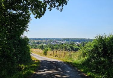
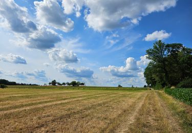
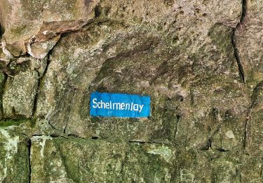
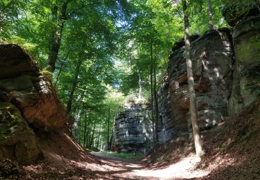
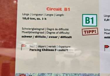
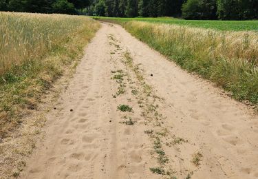
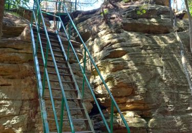
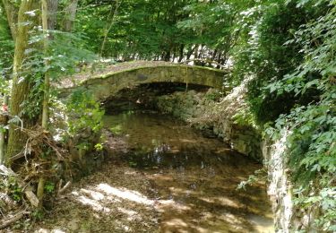
Depuis le P de l'hôtel Bisdorff, une très belle balade balisée B5 dans le massif du Schnellert et ses immenses blocs de grès. Un parcours accidenté " plutôt physique " avec ses nombreux escaliers.
Localisation
Pays :
Luxembourg
Région :
Inconnu
Département/Province :
Canton Echternach
Commune :
Berdorf
Localité :
Unknown
Départ:(Dec)
Départ:(UTM)
309237 ; 5521051 (32U) N.
Commentaires
Randonnées à proximité
![Randonnée Marche Consdorf - Consdorf - C6 - Photo](https://media.geolcdn.com/t/375/260/ext.jpg?maxdim=2&url=https%3A%2F%2Fmedia.geolcdn.com%2Ff%2F1a93b691-9fc1-4ff8-ae1a-57fcf6e1418e.jpg)
![Marche Marche](https://static1.geolcdn.com/sitytour/trail-icons/101.png)
Consdorf - C6
Marche
Moyen
(1)
Consdorf,
Inconnu,
Canton Echternach,
Luxembourg
![](/images/other/stat-length.png)
5,8 km | 7,3 km-effort
1h 39min
![](https://static1.geolcdn.com/siteimages/upload/files/16400158638029165_repeat_loop_refresh_sync_direction_icon.png)
Oui
![Randonnée Marche Consdorf - Consdorf - C2 (Müllerthal) - Photo](https://media.geolcdn.com/t/375/260/ext.jpg?maxdim=2&url=https%3A%2F%2Fmedia.geolcdn.com%2Ff%2F0cc79ac2-8683-4672-970a-cfe76e408507.jpg)
![Marche Marche](https://static1.geolcdn.com/sitytour/trail-icons/101.png)
Consdorf - C2 (Müllerthal)
Marche
Facile
(1)
Consdorf,
Inconnu,
Canton Echternach,
Luxembourg
![](/images/other/stat-length.png)
4,2 km | 5,5 km-effort
1h 15min
![](https://static1.geolcdn.com/siteimages/upload/files/16400158638029165_repeat_loop_refresh_sync_direction_icon.png)
Oui
![Randonnée Marche Consdorf - Consdorf - Mullerthal - Photo](https://media.geolcdn.com/t/375/260/ext.jpg?maxdim=2&url=https%3A%2F%2Fmedia.geolcdn.com%2Ff%2F43e83e22-9e28-4a45-bf58-3588aa9e8a2f.jpg)
![Marche Marche](https://static1.geolcdn.com/sitytour/trail-icons/101.png)
Consdorf - Mullerthal
Marche
Moyen
(1)
Consdorf,
Inconnu,
Canton Echternach,
Luxembourg
![](/images/other/stat-length.png)
9 km | 12,3 km-effort
2h 48min
![](https://static1.geolcdn.com/siteimages/upload/files/16400158638029165_repeat_loop_refresh_sync_direction_icon.png)
Oui
![Randonnée Marche Berdorf - Berdorf - B2 - Müllerthal - Photo](https://media.geolcdn.com/t/375/260/ext.jpg?maxdim=2&url=https%3A%2F%2Fmedia.geolcdn.com%2Ff%2F517daf86-eb8b-412e-9a7e-d0a346807e81.jpg)
![Marche Marche](https://static1.geolcdn.com/sitytour/trail-icons/101.png)
Berdorf - B2 - Müllerthal
Marche
Moyen
(1)
Berdorf,
Inconnu,
Canton Echternach,
Luxembourg
![](/images/other/stat-length.png)
6,7 km | 8,5 km-effort
1h 35min
![](https://static1.geolcdn.com/siteimages/upload/files/16400158638029165_repeat_loop_refresh_sync_direction_icon.png)
Oui
![Randonnée Marche Beaufort - Beaufort - B1 - Photo](https://media.geolcdn.com/t/375/260/ext.jpg?maxdim=2&url=https%3A%2F%2Fmedia.geolcdn.com%2Ff%2F9b40ebf8-55f0-408d-8504-76ef1490c879.jpg)
![Marche Marche](https://static1.geolcdn.com/sitytour/trail-icons/101.png)
Beaufort - B1
Marche
Moyen
(1)
Beaufort,
Inconnu,
Canton Echternach,
Luxembourg
![](/images/other/stat-length.png)
10,6 km | 13,6 km-effort
3h 5min
![](https://static1.geolcdn.com/siteimages/upload/files/16400158638029165_repeat_loop_refresh_sync_direction_icon.png)
Oui
![Randonnée Marche Beaufort - Mullerthal - Extra Tour B - Photo](https://media.geolcdn.com/t/375/260/ext.jpg?maxdim=2&url=https%3A%2F%2Fmedia.geolcdn.com%2Ff%2Fa4bdebcf-ad8b-4513-aa3a-a5e6b3892888.jpg)
![Marche Marche](https://static1.geolcdn.com/sitytour/trail-icons/101.png)
Mullerthal - Extra Tour B
Marche
Moyen
(2)
Beaufort,
Inconnu,
Canton Echternach,
Luxembourg
![](/images/other/stat-length.png)
12,9 km | 16,8 km-effort
3h 48min
![](https://static1.geolcdn.com/siteimages/upload/files/16400158638029165_repeat_loop_refresh_sync_direction_icon.png)
Oui
![Randonnée Marche Consdorf - Consdorf - Sentier local C1 - Photo](https://media.geolcdn.com/t/375/260/ext.jpg?maxdim=2&url=https%3A%2F%2Fmedia.geolcdn.com%2Ff%2F67bec963-192a-46c1-a89d-070dac0d9ebc.jpg)
![Marche Marche](https://static1.geolcdn.com/sitytour/trail-icons/101.png)
Consdorf - Sentier local C1
Marche
Facile
(1)
Consdorf,
Inconnu,
Canton Echternach,
Luxembourg
![](/images/other/stat-length.png)
1,9 km | 2,5 km-effort
34min
![](https://static1.geolcdn.com/siteimages/upload/files/16400158638029165_repeat_loop_refresh_sync_direction_icon.png)
Oui
![Randonnée Marche Berdorf - Berdorf - B8 - Müllerthal - Photo](https://media.geolcdn.com/t/375/260/ext.jpg?maxdim=2&url=https%3A%2F%2Fmedia.geolcdn.com%2Ff%2F7a8870ac-d558-4a39-b7c2-bdeb26e936c0.jpg)
![Marche Marche](https://static1.geolcdn.com/sitytour/trail-icons/101.png)
Berdorf - B8 - Müllerthal
Marche
Moyen
(1)
Berdorf,
Inconnu,
Canton Echternach,
Luxembourg
![](/images/other/stat-length.png)
11,7 km | 15 km-effort
3h 24min
![](https://static1.geolcdn.com/siteimages/upload/files/16400158638029165_repeat_loop_refresh_sync_direction_icon.png)
Oui
![Randonnée Marche Waldbillig - Mullerthal randonnée magnifique - Photo](https://media.geolcdn.com/t/375/260/ext.jpg?maxdim=2&url=https%3A%2F%2Fmedia.geolcdn.com%2Ff%2F3f58fb00-23e0-4e5f-be44-94a05c44c601.jpg)
![Marche Marche](https://static1.geolcdn.com/sitytour/trail-icons/101.png)
Mullerthal randonnée magnifique
Marche
Difficile
(4)
Waldbillig,
Inconnu,
Canton Echternach,
Luxembourg
![](/images/other/stat-length.png)
9,3 km | 12,9 km-effort
4h 21min
![](https://static1.geolcdn.com/siteimages/upload/files/16400158638029165_repeat_loop_refresh_sync_direction_icon.png)
Oui