Randonnée V.T.T. Thuir - Vinyer del Rei - Photo
 tracegps
tracegps

Utilisateur

© OpenStreetMap contributors
Longueur
Longueur
8,4 km
Altitude max
Altitude max
102 m
Dénivelé positif
Dénivelé positif
40 m
Km-Effort
Km-Effort  
8,9 km
Altitude min
Altitude min
84 m
Dénivelé négatif
Dénivelé négatif
39 m
Boucle
Boucle
Oui
Date de création :
2014-12-10 00:00:00.0
Dernière modification :
2014-12-10 00:00:00.0

(0 Avis)

V.T.T.
V.T.T.
30m
Difficulté : Facile

Scannez ce code QR pour ouvrir la randonnée dans l'application SityTrail

Application GPS de randonnée GRATUITE

Logo SityTrail SityTrail

IGN / Instituts géographiques

Télécharger SityTrail sur l'App Store Télécharger SityTrail sur Google Play

Logo SityTrail SityTrail World

Le monde est à vous

Télécharger SityTrail sur l'App Store Télécharger SityTrail sur Google Play Télécharger SityTrail sur Huawei AppGallery

À propos

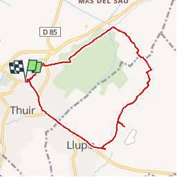
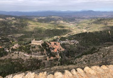
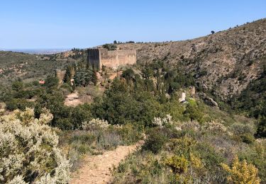
Randonnée V.T.T. de 8,4 km à découvrir à Occitanie, Pyrénées-Orientales, Thuir. Cette randonnée est proposée par tracegps.

Description

Découverte de la plaine viticole de Thuir. Circuit au départ des caves de BYRRH (à consommer avec modération)facile mais peu ombragé. Prévoir le nécessaire par temps chaud.

Profil altimétrique

Localisation

Pays :
France
Région :
Occitanie
Département/Province :
Pyrénées-Orientales
Commune :
Thuir
Localité :
Unknown
Départ:(Dec)
Départ:(UTM)
480042 ; 4720238 (31T) N.

Randonnées à proximité

Randonnée Marche Llupia - 66 LLUPIA - FOURQUES - TERRATS promenade dans les ASPRES et son vignoble  - Photo
Marche
jeff66

Marche

Moyen
(1)
Llupia, Occitanie, Pyrénées-Orientales, France
15 km | 18,2 km-effort
2h 36min
Oui
Randonnée Marche Castelnou - CASTELNOU 66 -  CAMELAS - ermitage San Marti de La Roca - Photo
Marche
jeff66

Marche

Difficile
(1)
Castelnou, Occitanie, Pyrénées-Orientales, France
10,8 km | 16,7 km-effort
2h 19min
Oui
Randonnée Marche Thuir - Thuir à Castelnou - Photo
Marche
timousse

Marche

Moyen
(1)
Thuir, Occitanie, Pyrénées-Orientales, France
14,1 km | 20 km-effort
4h 13min
Oui
Randonnée Marche Castelnou - Thuir  - Photo
Marche
Jean-François BALANGER

Marche

Très facile
(1)
Castelnou, Occitanie, Pyrénées-Orientales, France
9,3 km | 12,1 km-effort
4h 4min
Non
Randonnée Marche Castelnou - castel nous  - Photo
Marche
Jean-François BALANGER

Marche

Très facile
(1)
Castelnou, Occitanie, Pyrénées-Orientales, France
11,9 km | 16,7 km-effort
4h 0min
Oui
Randonnée Marche Sainte-Colombe-de-la-Commanderie - THUIR 66 - Castelnou - Ste Colombe de la C. - Photo
Marche
jeff66

Marche

Moyen
(2)
Sainte-Colombe-de-la-Commanderie, Occitanie, Pyrénées-Orientales, France
14,8 km | 21 km-effort
2h 56min
Oui
Randonnée Marche Sainte-Colombe-de-la-Commanderie - 20230316 Sté Colombe-Castelnou - Photo
Marche
ThonyM

Marche

Moyen
Sainte-Colombe-de-la-Commanderie, Occitanie, Pyrénées-Orientales, France
16,3 km | 23 km-effort
3h 55min
Oui
Randonnée Marche Castelnou - 20210328 Castelnou-Camelas- boucl - Photo
Marche
ThonyM

Marche

Moyen
Castelnou, Occitanie, Pyrénées-Orientales, France
15,4 km | 23 km-effort
4h 1min
Oui
Randonnée Marche Castelnou - Autour de Castelnou via St Marti de la Roca  - Photo
Marche
zazie

Marche

Moyen
Castelnou, Occitanie, Pyrénées-Orientales, France
13,5 km | 21 km-effort
3h 11min
Oui


Fermer
Mes abonnements