Randonnée V.T.T. Saint-Amans-Soult - Voie Verte Mazamet - Bédarieux - Etape 02 - Photo

Voie Verte Mazamet - Bédarieux - Etape 02

 tracegps
tracegps

Utilisateur

© OpenStreetMap contributors
Longueur
Longueur
8,3 km
Altitude max
Altitude max
346 m
Dénivelé positif
Dénivelé positif
112 m
Km-Effort
Km-Effort  
9,5 km
Altitude min
Altitude min
275 m
Dénivelé négatif
Dénivelé négatif
44 m
Boucle
Boucle
Non
Date de création :
2014-12-10 00:00:00.0
Dernière modification :
2014-12-10 00:00:00.0

(0 Avis)

V.T.T.
V.T.T.
45m
Difficulté : Facile

Scannez ce code QR pour ouvrir la randonnée dans l'application SityTrail

Application GPS de randonnée GRATUITE

Logo SityTrail SityTrail

IGN / Instituts géographiques

Télécharger SityTrail sur l'App Store Télécharger SityTrail sur Google Play

Logo SityTrail SityTrail World

Le monde est à vous

Télécharger SityTrail sur l'App Store Télécharger SityTrail sur Google Play Télécharger SityTrail sur Huawei AppGallery

À propos

Randonnée V.T.T. de 8,3 km à découvrir à Occitanie, Tarn, Saint-Amans-Soult. Cette randonnée est proposée par tracegps.

Description

Au cœur du Parc naturel régional, la "piste verte de Mazamet à Bédarieux" est la voie verte du Haut-Languedoc. Cette voie verte est en cours d'aménagement sur l’ancienne voie ferrée.

Profil altimétrique

Localisation

Pays :
France
Région :
Occitanie
Département/Province :
Tarn
Commune :
Saint-Amans-Soult
Localité :
Unknown
Départ:(Dec)
Départ:(UTM)
458810 ; 4814044 (31T) N.

Randonnées à proximité

Randonnée Marche Saint-Amans-Soult - Le sentier des Gentilshommes Verriers - Saint Amand Soult - Photo
Marche
tracegps

Marche

Moyen
Saint-Amans-Soult, Occitanie, Tarn, France
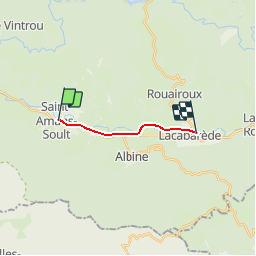
19,9 km | 31 km-effort
5h 30min
Oui
Randonnée Marche Mazamet - Retour Pic du Nore -Cabrespine  - Photo
Marche
jacques delaporte

Marche

Très difficile
Mazamet, Occitanie, Tarn, France
17,2 km | 23 km-effort
4h 50min
Non
Randonnée V.T.T. Saint-Amans-Valtoret - 2010-08-09 - 12h12m24 - Photo
V.T.T.
macleon

V.T.T.

Très facile
Saint-Amans-Valtoret, Occitanie, Tarn, France
38 km | 51 km-effort
Inconnu
Oui
Randonnée V.T.T. Saint-Amans-Soult - Athaïs - Photo
V.T.T.
tsang

V.T.T.

Saint-Amans-Soult, Occitanie, Tarn, France
27 km | 41 km-effort
3h 3min
Oui
Randonnée V.T.T. Saint-Amans-Soult - Athais 1er montagne noir - Photo
V.T.T.
tsang

V.T.T.

Difficile
Saint-Amans-Soult, Occitanie, Tarn, France
9,6 km | 18 km-effort
2h 0min
Oui
Randonnée A pied Albine - roc de peyremaux/stéle des aviateurs - Photo
A pied
Dupleix

A pied

Difficile
Albine, Occitanie, Tarn, France
15,5 km | 25 km-effort
Inconnu
Oui
Randonnée Marche Albine - 81_Albine - Photo
Marche
jab31

Marche

Difficile
Albine, Occitanie, Tarn, France
14,4 km | 23 km-effort
5h 12min
Oui
Randonnée Marche Mazamet - grande boucle du triby-Mazamet 81200 - Photo
Marche
Dupleix

Marche

Très difficile
Mazamet, Occitanie, Tarn, France
19,2 km | 27 km-effort
5h 41min
Oui
Randonnée Marche Saint-Amans-Valtoret - Lou Camin - Photo
Marche
philou6351

Marche

Facile
Saint-Amans-Valtoret, Occitanie, Tarn, France
19,5 km | 25 km-effort
4h 30min
Oui


Fermer
Mes abonnements