Randonnée V.T.T. Langeais - Rando Gadoue - Langeais - Photo
 tracegps
tracegps

Utilisateur

© OpenStreetMap contributors
Longueur
Longueur
47 km
Altitude max
Altitude max
113 m
Dénivelé positif
Dénivelé positif
529 m
Km-Effort
Km-Effort  
55 km
Altitude min
Altitude min
42 m
Dénivelé négatif
Dénivelé négatif
526 m
Boucle
Boucle
Oui
Date de création :
2014-12-10 00:00:00.0
Dernière modification :
2014-12-10 00:00:00.0

(0 Avis)

V.T.T.
V.T.T.
4h00
Difficulté : Difficile

Scannez ce code QR pour ouvrir la randonnée dans l'application SityTrail

Application GPS de randonnée GRATUITE

Logo SityTrail SityTrail

IGN / Instituts géographiques

Télécharger SityTrail sur l'App Store Télécharger SityTrail sur Google Play

Logo SityTrail SityTrail World

Le monde est à vous

Télécharger SityTrail sur l'App Store Télécharger SityTrail sur Google Play Télécharger SityTrail sur Huawei AppGallery

À propos

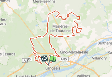
Randonnée V.T.T. de 47 km à découvrir à Centre-Val de Loire, Indre-et-Loire, Langeais. Cette randonnée est proposée par tracegps.

Description

Elle porte bien son nom...organisée par Les Sentiers Langeaisiens. Rando organisée généralement en novembre, quand il a bien plu. Assez difficile selon la saison car ça colle un pneu! Circuits sur les pentes de Langeais au milieu des châtaigniers. Jolis paysages.

Profil altimétrique

Localisation

Pays :
France
Région :
Centre-Val de Loire
Département/Province :
Indre-et-Loire
Commune :
Langeais
Localité :
Langeais
Départ:(Dec)
Départ:(UTM)
303434 ; 5244847 (31T) N.

Randonnées à proximité

Randonnée Marche Lignières-de-Touraine - Lignière de Touraine-Le 26-09-2013- Distance 10,4 km - Auteur tintin37 - Photo
Marche
Martinjeanclaude

Marche

Moyen
(2)
Lignières-de-Touraine, Centre-Val de Loire, Indre-et-Loire, France
10,4 km | 11,8 km-effort
2h 30min
Oui
Randonnée Marche Cinq-Mars-la-Pile - Cinq-Mars-la-Pile - Langeais - 14km 205m 3h05 - 2024 02 14 - Photo
Marche
Orcal37

Marche

Facile
Cinq-Mars-la-Pile, Centre-Val de Loire, Indre-et-Loire, France
14 km | 16,7 km-effort
3h 5min
Oui
Randonnée Marche Coteaux-sur-Loire - Saint-Michel-sur-Loire - GRP Coteaux de Bourgueil Saint-Patrice - 21.7km 240m 4h45 (35mn) - 2023 04 19 - Photo
Marche
Orcal37

Marche

Facile
Coteaux-sur-Loire, Centre-Val de Loire, Indre-et-Loire, France
22 km | 25 km-effort
4h 45min
Oui
Randonnée Marche Langeais - Langeais - PR Saint-Michel-sur-Loire - 20.8km 325m 5h10 (30mn) - 2023 04 15 - Photo
Marche
Orcal37

Marche

Moyen
Langeais, Centre-Val de Loire, Indre-et-Loire, France
21 km | 25 km-effort
5h 10min
Oui
Randonnée Marche Cinq-Mars-la-Pile - Cinq-Mars-la-Pile - le Mortier Rougeau - 19.5km 265m 4h30 - 2022 04 17 - Photo
Marche
Orcal37

Marche

Facile
Cinq-Mars-la-Pile, Centre-Val de Loire, Indre-et-Loire, France
19,7 km | 23 km-effort
4h 30min
Oui
Randonnée Marche Lignières-de-Touraine - Lignières-de-Touraine - la Chapelle-aux-Naux circuits 1 et 2 - 24km 175m 4h45 (45mn) - 2016 08 07 - Photo
Marche
Orcal37

Marche

Moyen
Lignières-de-Touraine, Centre-Val de Loire, Indre-et-Loire, France
24 km | 27 km-effort
4h 45min
Oui
Randonnée Marche Bréhémont - brehemont 2 - Photo
Marche
fustier

Marche

Très facile
Bréhémont, Centre-Val de Loire, Indre-et-Loire, France
22 km | 24 km-effort
5h 24min
Oui
Randonnée Marche Bréhémont - Bréhémont - 3.9km 15m 50mn - 2018 02 18 - Photo
Marche
Orcal37

Marche

Très facile
Bréhémont, Centre-Val de Loire, Indre-et-Loire, France
3,9 km | 4,2 km-effort
50min
Oui
Randonnée V.T.T. Cinq-Mars-la-Pile - Cinq Mars la Pile, Maziéres de Touraine, Langeais - Photo
V.T.T.
tracegps

V.T.T.

Difficile
Cinq-Mars-la-Pile, Centre-Val de Loire, Indre-et-Loire, France
26 km | 31 km-effort
1h 45min
Oui


Fermer
Mes abonnements