Randonnée V.T.T. Dabo - Circuit VTT du Sickert - Dabo - Photo

Circuit VTT du Sickert - Dabo

 tracegps
tracegps

Utilisateur

© OpenStreetMap contributors
Longueur
Longueur
9,4 km
Altitude max
Altitude max
551 m
Dénivelé positif
Dénivelé positif
279 m
Km-Effort
Km-Effort  
13,1 km
Altitude min
Altitude min
310 m
Dénivelé négatif
Dénivelé négatif
279 m
Boucle
Boucle
Oui
Date de création :
2014-12-10 00:00:00.0
Dernière modification :
2014-12-10 00:00:00.0

(0 Avis)

V.T.T.
V.T.T.
1h30
Difficulté : Difficile

Scannez ce code QR pour ouvrir la randonnée dans l'application SityTrail

Application GPS de randonnée GRATUITE

Logo SityTrail SityTrail

IGN / Instituts géographiques

Télécharger SityTrail sur l'App Store Télécharger SityTrail sur Google Play

Logo SityTrail SityTrail World

Le monde est à vous

Télécharger SityTrail sur l'App Store Télécharger SityTrail sur Google Play Télécharger SityTrail sur Huawei AppGallery

À propos

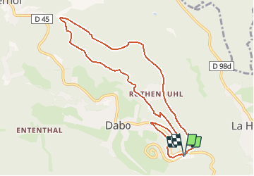
Randonnée V.T.T. de 9,4 km à découvrir à Grand Est, Moselle, Dabo. Cette randonnée est proposée par tracegps.

Description

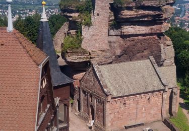
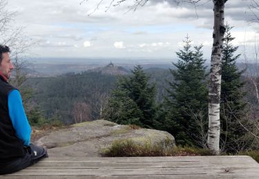
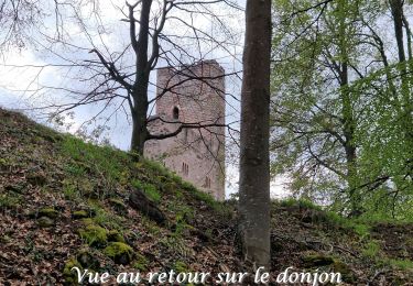
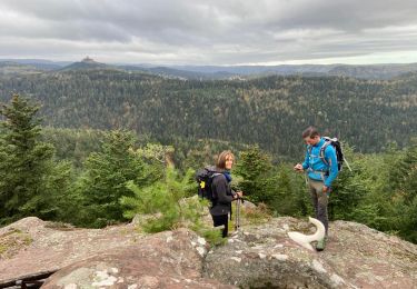
Le circuit part du camping et emprunte un sentier en direction de Rothenbuhl avant de bifurquer en direction du rocher du Sickert, magnifique piton de grès rose qui culmine à 508 m et à partir duquel on profite d’une vue superbe sur Dabo et son Rocher. Une descente assez technique mène ensuite aux abords de Lochmuehl et du Kuhberg. Le retour se fait par une montée régulière jusqu’à Dabo et son camping.

Profil altimétrique

Photos

Localisation

Pays :
France
Région :
Grand Est
Département/Province :
Moselle
Commune :
Dabo
Localité :
Unknown
Départ:(Dec)
Départ:(UTM)
371327 ; 5389855 (32U) N.

Randonnées à proximité

Randonnée Marche Reinhardsmunster - 2021-09-01 Marche Reinhardsmunster Haut Barr - Photo
Marche
GUIDE
holtzv

Marche

Très difficile
Reinhardsmunster, Grand Est, Bas-Rhin, France
21 km | 32 km-effort
6h 39min
Oui
Randonnée Marche Reinhardsmunster - 2020-06-13 Marche Ditschelkopf Schweizerberg - Photo
Marche
GUIDE
holtzv

Marche

Très facile
Reinhardsmunster, Grand Est, Bas-Rhin, France
14,5 km | 22 km-effort
4h 52min
Oui
Randonnée Marche Wangenbourg-Engenthal - 2020-03-14 Marche Engenthal le bas - Photo
Marche
GUIDE
holtzv

Marche

Très facile
Wangenbourg-Engenthal, Grand Est, Bas-Rhin, France
14,3 km | 22 km-effort
4h 27min
Oui
Randonnée Marche Wangenbourg-Engenthal - 2017-02-24 Marche Schneeberg - Photo
Marche
GUIDE
holtzv

Marche

Très facile
(1)
Wangenbourg-Engenthal, Grand Est, Bas-Rhin, France
12,8 km | 19,9 km-effort
Inconnu
Oui
Randonnée Marche Haselbourg - De Haselbourg au Rocher de Falkenfels - Photo
Marche
GUIDE
Desrumaux

Marche

Facile
(1)
Haselbourg, Grand Est, Moselle, France
6,4 km | 9,7 km-effort
2h 6min
Oui
Randonnée V.T.T. Dabo - Balcon de Dabo 2010 - Photo
V.T.T.
tracegps

V.T.T.

Très difficile
(1)
Dabo, Grand Est, Moselle, France
39 km | 54 km-effort
4h 30min
Oui
Randonnée Marche Wangenbourg-Engenthal - 20230426_rando_Wangenbourg_Chateaux de Freudeneck_Cascade-de-Mencke_Heidenschloss_Rotfels - Photo
Marche
nfranche

Marche

Moyen
Wangenbourg-Engenthal, Grand Est, Bas-Rhin, France
14,1 km | 22 km-effort
4h 56min
Oui
Randonnée Marche Dabo - 2022-11-01 Marche Dabo et ses Rochers - Photo
Marche
GUIDE
holtzv

Marche

Très difficile
Dabo, Grand Est, Moselle, France
26 km | 38 km-effort
7h 8min
Oui
Randonnée Marche nordique Wangenbourg-Engenthal - Engenthal  - Photo
Marche nordique
Michel 67

Marche nordique

Très facile
Wangenbourg-Engenthal, Grand Est, Bas-Rhin, France
9,9 km | 14 km-effort
2h 31min
Oui


Fermer
Mes abonnements