Randonnée V.T.T. Canohès - canohes - Photo
 haroldtheviking
haroldtheviking

Utilisateur

© OpenStreetMap contributors
Longueur
Longueur
37 km
Altitude max
Altitude max
345 m
Dénivelé positif
Dénivelé positif
508 m
Km-Effort
Km-Effort  
44 km
Altitude min
Altitude min
66 m
Dénivelé négatif
Dénivelé négatif
510 m
Boucle
Boucle
Oui
Date de création :
2014-12-10 00:00:00.0
Dernière modification :
2014-12-10 00:00:00.0

(2 Avis)

V.T.T.
V.T.T.
2h12
Difficulté : Moyen

Scannez ce code QR pour ouvrir la randonnée dans l'application SityTrail

Application GPS de randonnée GRATUITE

Logo SityTrail SityTrail

IGN / Instituts géographiques

Télécharger SityTrail sur l'App Store Télécharger SityTrail sur Google Play

Logo SityTrail SityTrail World

Le monde est à vous

Télécharger SityTrail sur l'App Store Télécharger SityTrail sur Google Play Télécharger SityTrail sur Huawei AppGallery

À propos

Randonnée V.T.T. de 37 km à découvrir à Occitanie, Pyrénées-Orientales, Canohès. Cette randonnée est proposée par haroldtheviking.

Profil altimétrique

Localisation

Pays :
France
Région :
Occitanie
Département/Province :
Pyrénées-Orientales
Commune :
Canohès
Localité :
Unknown
Départ:(Dec)
Départ:(UTM)
486253 ; 4721730 (31T) N.

Commentaires

Veuillez vous connecter pour laisser un commentaire ou une note


tres pratique mais j'aimerais modifier ce que j'ai mis moi-même je ne sais pas comment faire


une fois pris en main, c'est vraiment pratique


Randonnées à proximité

Randonnée Marche Perpignan - canal Perpignan  - Photo
Marche
Fildesir

Marche

Très facile
Perpignan, Occitanie, Pyrénées-Orientales, France
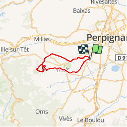
25 km | 27 km-effort
7h 29min
Non
Randonnée Marche Perpignan - 66 Perpignan Panchot centre bas Vernet centre del mon - Photo
Marche
jeff66

Marche

Facile
Perpignan, Occitanie, Pyrénées-Orientales, France
8,6 km | 9,3 km-effort
1h 29min
Oui
Randonnée Marche Perpignan - 66 PERPIGNAN - autour des mas Du petit et du grand Bresson - Photo
Marche
jeff66

Marche

Facile
Perpignan, Occitanie, Pyrénées-Orientales, France
4,3 km | 4,9 km-effort
52min
Oui
Randonnée Marche Perpignan - 66 PERPIGNAN, du sud au Nord Et retour - Photo
Marche
jeff66

Marche

Moyen
Perpignan, Occitanie, Pyrénées-Orientales, France
13,8 km | 15,4 km-effort
2h 40min
Oui
Randonnée Marche Perpignan - 66 PERPIGNAN - CANOHES par le canal et le ch. des Carlettes - Photo
Marche
jeff66

Marche

Moyen
(1)
Perpignan, Occitanie, Pyrénées-Orientales, France
9,4 km | 10,1 km-effort
1h 45min
Oui
Randonnée Marche Perpignan - 66 PERPIGNAN porte Espagne, les arcades, saint Martin, moulin à vent, vertefeuille, mas Gaffard - Photo
Marche
jeff66

Marche

Moyen
Perpignan, Occitanie, Pyrénées-Orientales, France
10,3 km | 11,7 km-effort
1h 48min
Oui
Randonnée Marche Perpignan - 66 PERPIGNAN, porte d'Espagne, quartier des aviateurs, les Arcades, Serrat d'en Vaquer, els Canals - Photo
Marche
jeff66

Marche

Facile
Perpignan, Occitanie, Pyrénées-Orientales, France
10,1 km | 11,5 km-effort
1h 52min
Oui
Randonnée Marche Perpignan - 66 PERPIGNAN, canal de Perpignan, centre commercial porte d'espagne, aqueduc des arcades, Ch. de Mailloles et de STE Barbe, Serrat d'en Vaquer - Photo
Marche
jeff66

Marche

Facile
Perpignan, Occitanie, Pyrénées-Orientales, France
9,8 km | 11,5 km-effort
1h 45min
Oui
Randonnée Marche Perpignan - 66 PERPIGNAN - de la Z.I.Sud au Centre Ville et retour par Saint-Mathieu - Photo
Marche
jeff66

Marche

Facile
Perpignan, Occitanie, Pyrénées-Orientales, France
7,8 km | 8,5 km-effort
1h 28min
Oui


Fermer
Mes abonnements