Randonnée Marche Ruy-Montceau - Rando GODAS 12 km juin 2013 - Photo

Rando GODAS 12 km juin 2013

 bourset
bourset

Utilisateur

© OpenStreetMap contributors
Longueur
Longueur
11,9 km
Altitude max
Altitude max
480 m
Dénivelé positif
Dénivelé positif
230 m
Km-Effort
Km-Effort  
15 km
Altitude min
Altitude min
415 m
Dénivelé négatif
Dénivelé négatif
229 m
Boucle
Boucle
Oui
Date de création :
2014-12-10 00:00:00.0
Dernière modification :
2014-12-10 00:00:00.0

(0 Avis)

Marche
Marche
3h11
Difficulté : Moyen

Scannez ce code QR pour ouvrir la randonnée dans l'application SityTrail

Application GPS de randonnée GRATUITE

Logo SityTrail SityTrail

IGN / Instituts géographiques

Télécharger SityTrail sur l'App Store Télécharger SityTrail sur Google Play

Logo SityTrail SityTrail World

Le monde est à vous

Télécharger SityTrail sur l'App Store Télécharger SityTrail sur Google Play Télécharger SityTrail sur Huawei AppGallery

À propos

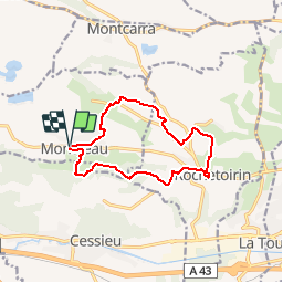
Randonnée Marche de 11,9 km à découvrir à Auvergne-Rhône-Alpes, Isère, Ruy-Montceau. Cette randonnée est proposée par bourset.

Description

Parcours moyen fléché bleu proposé par l'association les Godas lors de la "Randonnée de Kiki le 2 juin 2013

Profil altimétrique

Localisation

Pays :
France
Région :
Auvergne-Rhône-Alpes
Département/Province :
Isère
Commune :
Ruy-Montceau
Localité :
Unknown
Départ:(Dec)
Départ:(UTM)
685219 ; 5050959 (31T) N.

Randonnées à proximité

Randonnée Marche Vignieu - Vignieu - Saint Chef - Canal des moines  - Photo
Marche

Marche

Très difficile
Vignieu, Auvergne-Rhône-Alpes, Isère, France
15,6 km | 20 km-effort
4h 34min
Oui
Randonnée Marche Cessieu - Cessieu - Photo
Marche
alphonse22

Marche

Cessieu, Auvergne-Rhône-Alpes, Isère, France
8,2 km | 11,5 km-effort
2h 58min
Oui
Randonnée Marche Cessieu - Cessieu  - Photo
Marche
alphonse22

Marche

Cessieu, Auvergne-Rhône-Alpes, Isère, France
10,5 km | 14,7 km-effort
3h 8min
Oui
Randonnée Marche Cessieu - Cessiez - Photo
Marche
alphonse22

Marche

Cessieu, Auvergne-Rhône-Alpes, Isère, France
5,5 km | 7,3 km-effort
2h 11min
Non
Randonnée Marche Saint-Jean-de-Soudain - 2013 09 15 St-Jean de Soudain - Photo
Marche
lechner

Marche

Très facile
Saint-Jean-de-Soudain, Auvergne-Rhône-Alpes, Isère, France
16,7 km | 20 km-effort
1h 14min
Oui
Randonnée Cheval Saint-Victor-de-Cessieu - plaine GLAMS - Photo
Cheval
tifilou38

Cheval

Très facile
Saint-Victor-de-Cessieu, Auvergne-Rhône-Alpes, Isère, France
17,3 km | 19,3 km-effort
2h 0min
Oui
Randonnée Marche Montcarra - Sur les hauteurs de Montcarra - Photo
Marche
frdy69

Marche

Facile
(1)
Montcarra, Auvergne-Rhône-Alpes, Isère, France
6,8 km | 8 km-effort
1h 44min
Oui
Randonnée V.T.T. Rochetoirin - rochetoirin - Photo
V.T.T.
magyar

V.T.T.

Très facile
Rochetoirin, Auvergne-Rhône-Alpes, Isère, France
16,5 km | 21 km-effort
Inconnu
Oui
Randonnée Marche Vignieu - vigneu chevaux - Photo
Marche
jjjf01

Marche

Très facile
Vignieu, Auvergne-Rhône-Alpes, Isère, France
3,6 km | 4,3 km-effort
1h 26min
Oui


Fermer
Mes abonnements