![](/images/other/stat-length.png)
![Randonnée Marche Boisné-la-Tude - Juillaguet - Photo](https://media.geolcdn.com/t/1900/400/ext.pjpeg?maxdim=2&url=https%3A%2F%2Fmedia.geolcdn.com%2Ff%2Fe4f9898d-68dc-4df7-bb97-38377e29fa72.jpg)
Juillaguet
dorcier
Utilisateur
![Longueur](/images/other/stat-length.png)
Longueur
9,3 km
![Altitude max](https://static1.geolcdn.com/siteimages/upload/files/1508320355ic_sort_altitude_max_24dp.png)
Altitude max
181 m
![Dénivelé positif](https://static1.geolcdn.com/siteimages/upload/files/1508320355ic_sort_den_pos_24dp.png)
Dénivelé positif
155 m
![Km-Effort](/images/other/stat-length.png)
Km-Effort
11,4 km
![Altitude min](https://static1.geolcdn.com/siteimages/upload/files/1508320355ic_sort_altitude_min_24dp.png)
Altitude min
104 m
![Dénivelé négatif](https://static1.geolcdn.com/siteimages/upload/files/1508320355ic_sort_den_neg_24dp.png)
Dénivelé négatif
156 m
![Boucle](https://static1.geolcdn.com/siteimages/upload/files/16400158638029165_repeat_loop_refresh_sync_direction_icon.png)
Boucle
Oui
Date de création :
2019-04-18 12:01:04.0
Dernière modification :
2019-04-26 14:18:15.821
![Marche](https://static1.geolcdn.com/sitytour/trail-icons/101.png)
2h25
Difficulté : Moyen
![Scannez ce code QR pour ouvrir la randonnée dans l'application SityTrail](https://capi.geolives.com/qq0zvz2zws4bq2lad0pu/sitytour/trails/2064210/qr.png?size=200)
Application GPS de randonnée GRATUITE
À propos
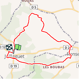
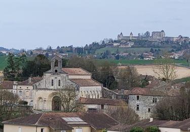
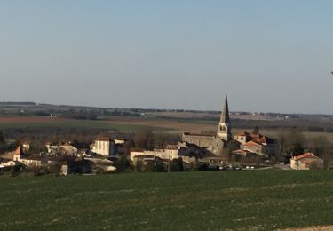
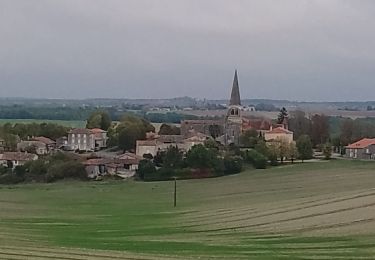
Randonnée Marche de 9,3 km à découvrir à Nouvelle-Aquitaine, Charente, Boisné-la-Tude. Cette randonnée est proposée par dorcier.
Description
Au départ du parking de la mairie de Juillaguet;
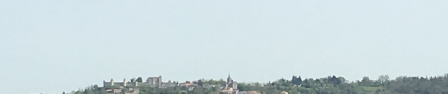
cette trace vous conduira dans la campagne vallonnée avec vue sur le château de La Mercerie et le village de Villebois-Lavalette.
Localisation
Pays :
France
Région :
Nouvelle-Aquitaine
Département/Province :
Charente
Commune :
Boisné-la-Tude
Localité :
Unknown
Départ:(Dec)
Départ:(UTM)
282149 ; 5039624 (31T) N.
Commentaires
Randonnées à proximité
![Randonnée Marche Ronsenac - La boucle de Ronsenac - Photo](https://media.geolcdn.com/t/375/260/ext.jpg?maxdim=2&url=https%3A%2F%2Fmedia.geolcdn.com%2Ff%2F77c5c751-67ff-49bd-b1bf-674cc5039611.jpg)
![Marche Marche](https://static1.geolcdn.com/sitytour/trail-icons/101.png)
La boucle de Ronsenac
Marche
Moyen
(1)
Ronsenac,
Nouvelle-Aquitaine,
Charente,
France
![](/images/other/stat-length.png)
8,4 km | 10 km-effort
2h 16min
![](https://static1.geolcdn.com/siteimages/upload/files/16400158638029165_repeat_loop_refresh_sync_direction_icon.png)
Oui
![Randonnée Marche Boisné-la-Tude - Chavenat - Photo](https://media.geolcdn.com/t/375/260/ext.jpg?maxdim=2&url=https%3A%2F%2Fservices.sitytrail.com%2FGeolivesWS%2FDownloadMedia.ashx%3FTrailID%3D385628%26Media%3Dfix__20150212153326.jpg)
![Marche Marche](https://static1.geolcdn.com/sitytour/trail-icons/101.png)
Chavenat
Marche
Facile
Boisné-la-Tude,
Nouvelle-Aquitaine,
Charente,
France
![](/images/other/stat-length.png)
8,1 km | 10,3 km-effort
2h 13min
![](https://static1.geolcdn.com/siteimages/upload/files/16400158638029165_repeat_loop_refresh_sync_direction_icon.png)
Oui
![Randonnée Marche Ronsenac - ronsenac2103 - Photo](https://media.geolcdn.com/t/375/260/ext.jpg?maxdim=2&url=https%3A%2F%2Fmedia.geolcdn.com%2Ff%2F1986dc57-e661-4a0b-b5cd-8f6c99d7b9af.jpg)
![Marche Marche](https://static1.geolcdn.com/sitytour/trail-icons/101.png)
ronsenac2103
Marche
Moyen
Ronsenac,
Nouvelle-Aquitaine,
Charente,
France
![](/images/other/stat-length.png)
6,9 km | 8,2 km-effort
2h 6min
![](https://static1.geolcdn.com/siteimages/upload/files/16400158638029165_repeat_loop_refresh_sync_direction_icon.png)
Oui
![Randonnée Marche Boisné-la-Tude - Charmant - Photo](https://media.geolcdn.com/t/375/260/ext.jpg?maxdim=2&url=https%3A%2F%2Fmedia.geolcdn.com%2Ff%2F5c8dce7e-483d-4d40-a890-3e7fd569cbf1.jpg)
![Marche Marche](https://static1.geolcdn.com/sitytour/trail-icons/101.png)
Charmant
Marche
Moyen
Boisné-la-Tude,
Nouvelle-Aquitaine,
Charente,
France
![](/images/other/stat-length.png)
11,9 km | 15,1 km-effort
3h 14min
![](https://static1.geolcdn.com/siteimages/upload/files/16400158638029165_repeat_loop_refresh_sync_direction_icon.png)
Oui
![Randonnée Marche Boisné-la-Tude - Charmant - Photo](https://media.geolcdn.com/t/375/260/ext.jpg?maxdim=2&url=https%3A%2F%2Fmedia.geolcdn.com%2Ff%2Fa4017e28-acd1-42f9-8abe-5031a51012c7.jpg)
![Marche Marche](https://static1.geolcdn.com/sitytour/trail-icons/101.png)
Charmant
Marche
Moyen
Boisné-la-Tude,
Nouvelle-Aquitaine,
Charente,
France
![](/images/other/stat-length.png)
6,8 km | 8,4 km-effort
1h 53min
![](https://static1.geolcdn.com/siteimages/upload/files/16400158638029165_repeat_loop_refresh_sync_direction_icon.png)
Oui
![Randonnée Marche Boisné-la-Tude - CHAVENAT - Photo](https://media.geolcdn.com/t/375/260/ext.jpg?maxdim=2&url=https%3A%2F%2Fstatic1.geolcdn.com%2Fsiteimages%2Fupload%2Ffiles%2F1553511878bg_sport_marche.png)
![Marche Marche](https://static1.geolcdn.com/sitytour/trail-icons/101.png)
CHAVENAT
Marche
Facile
Boisné-la-Tude,
Nouvelle-Aquitaine,
Charente,
France
![](/images/other/stat-length.png)
10,1 km | 12,7 km-effort
2h 50min
![](https://static1.geolcdn.com/siteimages/upload/files/16400158638029165_repeat_loop_refresh_sync_direction_icon.png)
Oui
![Randonnée Marche Boisné-la-Tude - Charmant à cheval à pied 14-09-2014 - Photo](https://media.geolcdn.com/t/375/260/ext.jpg?maxdim=2&url=https%3A%2F%2Fstatic1.geolcdn.com%2Fsiteimages%2Fupload%2Ffiles%2F1553511878bg_sport_marche.png)
![Marche Marche](https://static1.geolcdn.com/sitytour/trail-icons/101.png)
Charmant à cheval à pied 14-09-2014
Marche
Facile
Boisné-la-Tude,
Nouvelle-Aquitaine,
Charente,
France
![](/images/other/stat-length.png)
19,3 km | 22 km-effort
4h 50min
![](https://static1.geolcdn.com/siteimages/upload/files/16400158638029165_repeat_loop_refresh_sync_direction_icon.png)
Oui
![Randonnée Cheval Boisné-la-Tude - Charmant à cheval 13-09-2014 - Photo](https://media.geolcdn.com/t/375/260/ext.jpg?maxdim=2&url=https%3A%2F%2Fstatic1.geolcdn.com%2Fsiteimages%2Fupload%2Ffiles%2F1524743154cheval.jpg)
![Cheval Cheval](https://static1.geolcdn.com/sitytour/trail-icons/300.png)
Charmant à cheval 13-09-2014
Cheval
Facile
Boisné-la-Tude,
Nouvelle-Aquitaine,
Charente,
France
![](/images/other/stat-length.png)
21 km | 27 km-effort
3h 25min
![](https://static1.geolcdn.com/siteimages/upload/files/16400158638029165_repeat_loop_refresh_sync_direction_icon.png)
Oui
![Randonnée Marche Ronsenac - Juillaguet 2023 - Photo](https://media.geolcdn.com/t/375/260/ext.jpg?maxdim=2&url=https%3A%2F%2Fstatic1.geolcdn.com%2Fsiteimages%2Fupload%2Ffiles%2F1553511878bg_sport_marche.png)
![Marche Marche](https://static1.geolcdn.com/sitytour/trail-icons/101.png)
Juillaguet 2023
Marche
Moyen
Ronsenac,
Nouvelle-Aquitaine,
Charente,
France
![](/images/other/stat-length.png)
7,7 km | 9,3 km-effort
2h 4min
![](https://static1.geolcdn.com/siteimages/upload/files/16400158638029165_repeat_loop_refresh_sync_direction_icon.png)
Non