Randonnée V.T.C. Saint-Amand-Montrond - le Veurdre  - Photo
 dgrimault
dgrimault

Utilisateur

© OpenStreetMap contributors
Longueur
Longueur
61 km
Altitude max
Altitude max
227 m
Dénivelé positif
Dénivelé positif
392 m
Km-Effort
Km-Effort  
66 km
Altitude min
Altitude min
157 m
Dénivelé négatif
Dénivelé négatif
366 m
Boucle
Boucle
Non
Date de création :
2019-05-30 08:40:48.886
Dernière modification :
2019-05-30 12:58:01.874

(0 Avis)

V.T.C.
V.T.C.
4h16
Difficulté : Très facile

Scannez ce code QR pour ouvrir la randonnée dans l'application SityTrail

Application GPS de randonnée GRATUITE

Logo SityTrail SityTrail

IGN / Instituts géographiques

Télécharger SityTrail sur l'App Store Télécharger SityTrail sur Google Play

Logo SityTrail SityTrail World

Le monde est à vous

Télécharger SityTrail sur l'App Store Télécharger SityTrail sur Google Play Télécharger SityTrail sur Huawei AppGallery

À propos

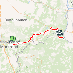
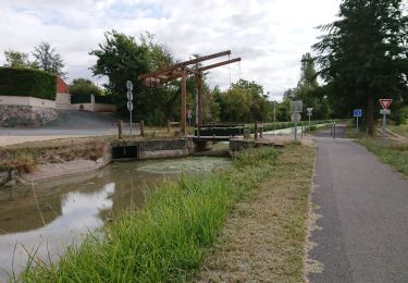
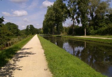
Randonnée V.T.C. de 61 km à découvrir à Centre-Val de Loire, Cher, Saint-Amand-Montrond. Cette randonnée est proposée par dgrimault.

Description

saint amand montrond. le Veurdre

Profil altimétrique

Localisation

Pays :
France
Région :
Centre-Val de Loire
Département/Province :
Cher
Commune :
Saint-Amand-Montrond
Localité :
Unknown
Départ:(UTM)
462241 ; 5173971 (31T) N.

Randonnées à proximité

Randonnée V.T.C. Orval - saint amand montrond vallon  - Photo
V.T.C.
dgrimault

V.T.C.

Très facile
Orval, Centre-Val de Loire, Cher, France
28 km | 31 km-effort
1h 27min
Non
Randonnée Marche Saint-Amand-Montrond - Remise en forme le long du Canal de Berry - Saint Amand Montrond - Photo
Marche
tracegps

Marche

Moyen
Saint-Amand-Montrond, Centre-Val de Loire, Cher, France
12,4 km | 13,2 km-effort
2h 10min
Oui
Randonnée Marche Saint-Amand-Montrond - Compostelle etape 9 et 10 - Photo
Marche
maginot

Marche

Moyen
Saint-Amand-Montrond, Centre-Val de Loire, Cher, France
63 km | 72 km-effort
16h 19min
Non
Randonnée V.T.T. Saint-Amand-Montrond - Tour du lac de Virlay - Photo
V.T.T.
Pat_83200

V.T.T.

Très facile
Saint-Amand-Montrond, Centre-Val de Loire, Cher, France
5,9 km | 6,2 km-effort
33min
Oui
Randonnée Marche Drevant - drevant - Photo
Marche
fournieralain

Marche

Très facile
Drevant, Centre-Val de Loire, Cher, France
4,5 km | 5,3 km-effort
1h 26min
Non
Randonnée Marche Saint-Amand-Montrond - canal du Berry - Photo
Marche
fournieralain

Marche

Très facile
Saint-Amand-Montrond, Centre-Val de Loire, Cher, France
7,7 km | 8,1 km-effort
1h 58min
Oui
Randonnée V.T.T. Saint-Amand-Montrond - 3 Saint Amand Montrond-Neuvy-St Jacques de Compostelle - Photo
V.T.T.
nicolas54230

V.T.T.

Difficile
Saint-Amand-Montrond, Centre-Val de Loire, Cher, France
107 km | 123 km-effort
8h 1min
Non
Randonnée Marche Saint-Amand-Montrond - la Tranchasse - Photo
Marche
charcamval

Marche

Très facile
Saint-Amand-Montrond, Centre-Val de Loire, Cher, France
31 km | 34 km-effort
Inconnu
Oui
Randonnée Marche Saint-Amand-Montrond - randonnée dt amand - Photo
Marche
lololen33

Marche

Facile
Saint-Amand-Montrond, Centre-Val de Loire, Cher, France
20 km | 23 km-effort
3h 8min
Oui


Fermer
Mes abonnements