Randonnée Marche Plounéour-Ménez - Abbaye du Relec- Plounéour Ménez - Photo

Abbaye du Relec- Plounéour Ménez

 tracegps
tracegps

Utilisateur

© OpenStreetMap contributors
Longueur
Longueur
16,8 km
Altitude max
Altitude max
342 m
Dénivelé positif
Dénivelé positif
305 m
Km-Effort
Km-Effort  
21 km
Altitude min
Altitude min
190 m
Dénivelé négatif
Dénivelé négatif
305 m
Boucle
Boucle
Oui
Date de création :
2014-12-10 00:00:00.0
Dernière modification :
2014-12-10 00:00:00.0

(0 Avis)

Marche
Marche
4h00
Difficulté : Moyen

Scannez ce code QR pour ouvrir la randonnée dans l'application SityTrail

Application GPS de randonnée GRATUITE

Logo SityTrail SityTrail

IGN / Instituts géographiques

Télécharger SityTrail sur l'App Store Télécharger SityTrail sur Google Play

Logo SityTrail SityTrail World

Le monde est à vous

Télécharger SityTrail sur l'App Store Télécharger SityTrail sur Google Play Télécharger SityTrail sur Huawei AppGallery

À propos

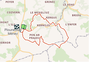
Randonnée Marche de 16,8 km à découvrir à Bretagne, Finistère, Plounéour-Ménez. Cette randonnée est proposée par tracegps.

Description

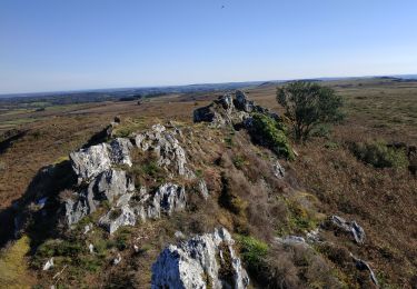
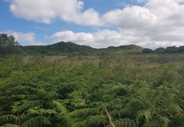
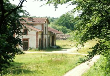
Départ de Guirhoel à Plounéour Menez, à travers bois et champs, direction l'abbaye du Relec. Retour par les crêtes des Monts d'Arrée. Paysage de landes avec points de vue. Rando relativement longue mais des possibilités de couper.

Profil altimétrique

Photos

Localisation

Pays :
France
Région :
Bretagne
Département/Province :
Finistère
Commune :
Plounéour-Ménez
Localité :
Unknown
Départ:(Dec)
Départ:(UTM)
434702 ; 5365417 (30U) N.

Randonnées à proximité

Randonnée V.T.T. Plounéour-Ménez - Espace VTT-FFC Morlaix Monts d'Arrée, circuit n°7 - Le Cloitre - Photo
V.T.T.
tracegps

V.T.T.

Très difficile
(1)
Plounéour-Ménez, Bretagne, Finistère, France
32 km | 39 km-effort
2h 30min
Oui
Randonnée A pied Plounéour-Ménez - Circuit de la Montagne - Photo
A pied
PRO

A pied

Facile
Plounéour-Ménez, Bretagne, Finistère, France
11 km | 13,5 km-effort
3h 3min
Oui
Randonnée Marche Plounéour-Ménez - PLONÉOUR MENEZ - Photo
Marche
RonanDAGORN

Marche

Difficile
Plounéour-Ménez, Bretagne, Finistère, France
22 km | 28 km-effort
5h 5min
Oui
Randonnée Marche La Feuillée - 2023-10-08 Roc'h trévezel - Roc'h ruz  - Photo
Marche
jacq58

Marche

Très facile
La Feuillée, Bretagne, Finistère, France
6,3 km | 7,4 km-effort
1h 33min
Oui
Randonnée A pied Berrien - Circuit de l'abbaye du Relec - Photo
A pied
PRO

A pied

Facile
Berrien, Bretagne, Finistère, France
12,6 km | 15,9 km-effort
3h 36min
Oui
Randonnée Marche Plounéour-Ménez - Balade de l'abbaye de Relecq - Photo
Marche
neleda

Marche

Très facile
(1)
Plounéour-Ménez, Bretagne, Finistère, France
13,2 km | 16,5 km-effort
3h 14min
Oui
Randonnée Marche Plounéour-Ménez - roc Trevezel 07/19 - Photo
Marche
ploizon

Marche

Moyen
Plounéour-Ménez, Bretagne, Finistère, France
11,8 km | 14,6 km-effort
2h 37min
Non
Randonnée Marche Plounéour-Ménez - Espace VTT-FFC Morlaix Monts d'Arrée, circuit n°7 - Le Cloitre - Photo
Marche
tracegps

Marche

Très difficile
Plounéour-Ménez, Bretagne, Finistère, France
32 km | 39 km-effort
6h 0min
Oui
Randonnée V.T.T. Plounéour-Ménez - Espace VTT-FFC Morlaix Monts d'Arrée, circuit n°6 - Le Relec - Photo
V.T.T.
tracegps

V.T.T.

Très difficile
Plounéour-Ménez, Bretagne, Finistère, France
18,1 km | 22 km-effort
1h 30min
Oui


Fermer
Mes abonnements