Randonnée Marche Châlonvillars - chalonvillars - moulin - frahier - evette-salbert - vierge - bois de chalonvillars - chalonvillars - Photo

chalonvillars - moulin - frahier - evette-salbert - vierge - bois de chalonvillars - chalonvillars

 lebrisgerard
lebrisgerard

Utilisateur

© OpenStreetMap contributors
Longueur
Longueur
21 km
Altitude max
Altitude max
504 m
Dénivelé positif
Dénivelé positif
314 m
Km-Effort
Km-Effort  
25 km
Altitude min
Altitude min
353 m
Dénivelé négatif
Dénivelé négatif
317 m
Boucle
Boucle
Oui
Date de création :
2019-08-17 15:35:56.088
Dernière modification :
2019-08-22 16:19:56.857

(0 Avis)

Marche
Marche
5h23
Difficulté : Très difficile
Vélo de route
Vélo de route
1h26
Difficulté : Moyen
V.T.T.
V.T.T.
1h38
Difficulté : Moyen
Vélo électrique
Vélo électrique
--
Difficulté : Très facile

Scannez ce code QR pour ouvrir la randonnée dans l'application SityTrail

Application GPS de randonnée GRATUITE

Logo SityTrail SityTrail

IGN / Instituts géographiques

Télécharger SityTrail sur l'App Store Télécharger SityTrail sur Google Play

Logo SityTrail SityTrail World

Le monde est à vous

Télécharger SityTrail sur l'App Store Télécharger SityTrail sur Google Play Télécharger SityTrail sur Huawei AppGallery

À propos

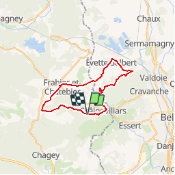
Randonnée Marche de 21 km à découvrir à Bourgogne-Franche-Comté, Haute-Saône, Châlonvillars. Cette randonnée est proposée par lebrisgerard.

Description

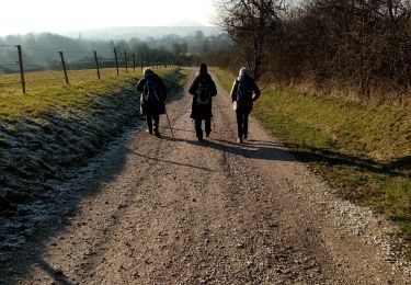
Belle rando sur route, très peu fréquentée par les autos. Très difficile,  il faut être entrainé à faire de la distance.
Peut-être fait également en vélo, là, c'est moyen.

Profil altimétrique

Localisation

Pays :
France
Région :
Bourgogne-Franche-Comté
Département/Province :
Haute-Saône
Commune :
Châlonvillars
Localité :
Unknown
Départ:(UTM)
332874 ; 5278690 (32T) N.

Randonnées à proximité

Randonnée Marche Sermamagny - Veronne PC - Photo
Marche
Papamoju

Marche

Très facile
(2)
Sermamagny, Bourgogne-Franche-Comté, Territoire-de-Belfort, France
8,1 km | 9 km-effort
1h 59min
Oui
Randonnée Marche Mandrevillars - Echenans et son fort - Photo
Marche
Bart2015

Marche

Très difficile
Mandrevillars, Bourgogne-Franche-Comté, Haute-Saône, France
14,8 km | 19,6 km-effort
4h 27min
Oui
Randonnée Marche Châlonvillars - Châlonvillars - Fort du Salbert - Evette-Salbert - Photo
Marche
Bart2015

Marche

Difficile
(1)
Châlonvillars, Bourgogne-Franche-Comté, Haute-Saône, France
11 km | 15,8 km-effort
3h 36min
Oui
Randonnée V.T.T. Châlonvillars - Châlonvillars - Fort Giromagny en passant au milieu des étangs - Photo
V.T.T.
Bart2015

V.T.T.

Très difficile
Châlonvillars, Bourgogne-Franche-Comté, Haute-Saône, France
40 km | 51 km-effort
3h 31min
Oui
Randonnée V.T.T. Châlonvillars - Châlonvillars - Menhir - Mandrevillars - Fort Essert et du Salbert - Photo
V.T.T.
Bart2015

V.T.T.

Très difficile
Châlonvillars, Bourgogne-Franche-Comté, Haute-Saône, France
31 km | 42 km-effort
2h 53min
Oui
Randonnée Marche Châlonvillars - Châlonvillars - le mehnir - Mandrevillars - Photo
Marche
Bart2015

Marche

Moyen
Châlonvillars, Bourgogne-Franche-Comté, Haute-Saône, France
13,4 km | 17,1 km-effort
2h 39min
Oui
Randonnée Marche Châlonvillars - Châlonvillars - Mandrevillars - Photo
Marche
Bart2015

Marche

Facile
Châlonvillars, Bourgogne-Franche-Comté, Haute-Saône, France
9,5 km | 11,9 km-effort
1h 33min
Oui
Randonnée Marche Frahier-et-Chatebier - frahier - Photo
Marche
Evelyne3

Marche

Moyen
(1)
Frahier-et-Chatebier, Bourgogne-Franche-Comté, Haute-Saône, France
5,6 km | 6,8 km-effort
1h 44min
Oui
Randonnée Marche Châlonvillars - Châlonvillars - Mandrevillars par les bois - Photo
Marche
Bart2015

Marche

Facile
Châlonvillars, Bourgogne-Franche-Comté, Haute-Saône, France
10,4 km | 12,9 km-effort
1h 40min
Oui


Fermer
Mes abonnements