Randonnée Autre activité Lauenen - Wildhorn tour 4/4 - Photo
 Bachmann
Bachmann

Utilisateur

© OpenStreetMap contributors
Longueur
Longueur
11,9 km
Altitude max
Altitude max
2383 m
Dénivelé positif
Dénivelé positif
684 m
Km-Effort
Km-Effort  
22 km
Altitude min
Altitude min
1590 m
Dénivelé négatif
Dénivelé négatif
1096 m
Boucle
Boucle
Non
Date de création :
2014-12-11 00:00:00.0
Dernière modification :
2014-12-11 00:00:00.0

(0 Avis)

Autre activité
Autre activité
--
Difficulté : Inconnu

Scannez ce code QR pour ouvrir la randonnée dans l'application SityTrail

Application GPS de randonnée GRATUITE

Logo SityTrail SityTrail

IGN / Instituts géographiques

Télécharger SityTrail sur l'App Store Télécharger SityTrail sur Google Play

Logo SityTrail SityTrail World

Le monde est à vous

Télécharger SityTrail sur l'App Store Télécharger SityTrail sur Google Play Télécharger SityTrail sur Huawei AppGallery

À propos

Randonnée Autre activité de 11,9 km à découvrir à Berne, Arrondissement administratif du Haut-Simmental et Gessenay, Lauenen. Cette randonnée est proposée par Bachmann.

Description

Dernière étape du tour en 4 jours, qui évite la cabane du Wildhorn (détour possible, un jour de plus). Le tracé choisi passe sur le flanc nord de Steiretungel (zone 138000/594000), la montée directe par le point 2271 étant très exposée.

Profil altimétrique

Localisation

Pays :
Suisse
Région :
Berne
Département/Province :
Arrondissement administratif du Haut-Simmental et Gessenay
Commune :
Lauenen
Localité :
Unknown
Départ:(Dec)
Départ:(UTM)
372275 ; 5136448 (32T) N.

Randonnées à proximité

Randonnée Marche Ayent - Tour du Wildhorn, jour 5 - Photo
Marche
GUIDE+

Marche

Très facile
Ayent, Valais, Hérens, Suisse
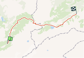
12,9 km | 23 km-effort
5h 0min
Non
Randonnée Marche La Lenk - Tour du Wildhorn, jour 3 - Photo
Marche
GUIDE+

Marche

Très facile
La Lenk, Berne, Arrondissement administratif du Haut-Simmental et Gessenay, Suisse
10,2 km | 25 km-effort
6h 0min
Non
Randonnée Marche Lauenen - Tour du Wildhorn, jour 2 - Photo
Marche
GUIDE+

Marche

Très facile
Lauenen, Berne, Arrondissement administratif du Haut-Simmental et Gessenay, Suisse
7,1 km | 15,4 km-effort
4h 0min
Non
Randonnée Marche Savièse - Tour du Wildhorn, jour 1 - Photo
Marche
GUIDE+

Marche

Très facile
Savièse, Valais, Sion, Suisse
14,6 km | 28 km-effort
6h 0min
Non
Randonnée Marche Ayent - st_bg_rawyl - Photo
Marche
GUIDE+

Marche

Très facile
Ayent, Valais, Hérens, Suisse
11,2 km | 19,7 km-effort
4h 4min
Non
Randonnée Marche Savièse - st_bg_antannes - Photo
Marche
GUIDE+

Marche

Très facile
Savièse, Valais, Sion, Suisse
8,9 km | 19,1 km-effort
Inconnu
Non
Randonnée Marche Lauenen - Gstaad: Lauenensee / SAC Geltenhütte - Photo
Marche
GUIDE+

Marche

Très facile
Lauenen, Berne, Arrondissement administratif du Haut-Simmental et Gessenay, Suisse
7,6 km | 16,5 km-effort
Inconnu
Non
Randonnée Marche Ayent - st_koreatv08_06 - Photo
Marche
GUIDE+

Marche

Très facile
Ayent, Valais, Hérens, Suisse
12,9 km | 25 km-effort
4h 14min
Non
Randonnée Marche Savièse - huetten_04 - Photo
Marche
GUIDE+

Marche

Très facile
Savièse, Valais, Sion, Suisse
56 km | 116 km-effort
19h 7min
Oui


Fermer
Mes abonnements