Trail Other activity Lauenen - Wildhorn tour 4/4 - Photo
 Bachmann
Bachmann

User

© OpenStreetMap contributors
Length
Length
11.9 km
Max alt
Max alt
2383 m
Uphill gradient
Uphill gradient
684 m
Km-Effort
Km-Effort  
22 km
Min alt
Min alt
1590 m
Downhill gradient
Downhill gradient
1096 m
Boucle
Boucle
No
Creation date :
2014-12-11 00:00:00.0
Updated on :
2014-12-11 00:00:00.0

(0 Reviews)

Other activity
Other activity
--
Difficulty : Unknown

Scan this QR Code to open this trail in the SityTrail application

FREE GPS app for hiking

Logo SityTrail SityTrail

IGN / Geographical institutes

Download SityTrail from the App Store Download SityTrail from Google Play

Logo SityTrail SityTrail World

The world is yours!

Download SityTrail from the App Store Download SityTrail from Google Play Download SityTrail on Huawei AppGallery

About

Trail Other activity of 11.9 km to be discovered at Bern, Obersimmental-Saanen administrative district, Lauenen. This trail is proposed by Bachmann.

Description

Dernière étape du tour en 4 jours, qui évite la cabane du Wildhorn (détour possible, un jour de plus). Le tracé choisi passe sur le flanc nord de Steiretungel (zone 138000/594000), la montée directe par le point 2271 étant très exposée.

Elevation profile

Positioning

Country:
Switzerland
Region :
Bern
Department/Province :
Obersimmental-Saanen administrative district
Municipality :
Lauenen
Location:
Unknown
Start:(UTM)
372275 ; 5136448 (32T) N.

Trails nearby

Trail Walking Ayent - Tour du Wildhorn, jour 5 - Photo
Walking
GUIDE+

Walking

Very easy
Ayent, Valais/Wallis, Hérens, Switzerland
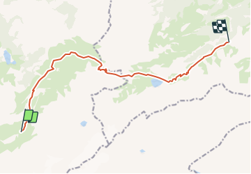
12.9 km | 23 km-effort
5h 0min
No
Trail Walking Lenk - Tour du Wildhorn, jour 3 - Photo
Walking
GUIDE+

Walking

Very easy
Lenk, Bern, Obersimmental-Saanen administrative district, Switzerland
10.2 km | 25 km-effort
6h 0min
No
Trail Walking Lauenen - Tour du Wildhorn, jour 2 - Photo
Walking
GUIDE+

Walking

Very easy
Lauenen, Bern, Obersimmental-Saanen administrative district, Switzerland
7.1 km | 15.4 km-effort
4h 0min
No
Trail Walking Savièse - Tour du Wildhorn, jour 1 - Photo
Walking
GUIDE+

Walking

Very easy
Savièse, Valais/Wallis, Sion, Switzerland
14.6 km | 28 km-effort
6h 0min
No
Trail Walking Ayent - st_bg_rawyl - Photo
Walking
GUIDE+

Walking

Very easy
Ayent, Valais/Wallis, Hérens, Switzerland
11.2 km | 19.7 km-effort
4h 4min
No
Trail Walking Savièse - st_bg_antannes - Photo
Walking
GUIDE+

Walking

Very easy
Savièse, Valais/Wallis, Sion, Switzerland
8.9 km | 19.1 km-effort
Unknown
No
Trail Walking Lauenen - Gstaad: Lauenensee / SAC Geltenhütte - Photo
Walking
GUIDE+

Walking

Very easy
Lauenen, Bern, Obersimmental-Saanen administrative district, Switzerland
7.6 km | 16.5 km-effort
Unknown
No
Trail Walking Ayent - st_koreatv08_06 - Photo
Walking
GUIDE+

Walking

Very easy
Ayent, Valais/Wallis, Hérens, Switzerland
12.9 km | 25 km-effort
4h 14min
No
Trail Walking Savièse - huetten_04 - Photo
Walking
GUIDE+

Walking

Very easy
Savièse, Valais/Wallis, Sion, Switzerland
56 km | 116 km-effort
19h 7min
Yes


Close
My subscriptions