![](/images/other/stat-length.png)
![Randonnée Cheval Saint-Hubert - Chevauchée sur les pas de Saint Hubert - Photo](https://media.geolcdn.com/t/1900/400/ext.pjpeg?maxdim=2&url=https%3A%2F%2Fmedia.geolcdn.com%2Ff%2F9c456c04-0ab9-49a9-958c-d7630f896b2c.jpg)
Chevauchée sur les pas de Saint Hubert
La Grande Forêt de Saint-Hubert
Randonnées de la Grande Forêt de Saint-Hubert GUIDE+
![Longueur](/images/other/stat-length.png)
![Altitude max](https://static1.geolcdn.com/siteimages/upload/files/1508320355ic_sort_altitude_max_24dp.png)
![Dénivelé positif](https://static1.geolcdn.com/siteimages/upload/files/1508320355ic_sort_den_pos_24dp.png)
![Km-Effort](/images/other/stat-length.png)
![Altitude min](https://static1.geolcdn.com/siteimages/upload/files/1508320355ic_sort_altitude_min_24dp.png)
![Dénivelé négatif](https://static1.geolcdn.com/siteimages/upload/files/1508320355ic_sort_den_neg_24dp.png)
![Boucle](https://static1.geolcdn.com/siteimages/upload/files/16400158638029165_repeat_loop_refresh_sync_direction_icon.png)
![Cheval](https://static1.geolcdn.com/sitytour/trail-icons/300.png)
1h40
Difficulté : Inconnu
![Scannez ce code QR pour ouvrir la randonnée dans l'application SityTrail](https://capi.geolives.com/qq0zvz2zws4bq2lad0pu/sitytour/trails/2351438/qr.png?size=200)
Application GPS de randonnée GRATUITE
À propos
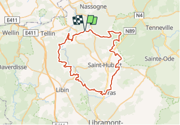
Randonnée Cheval de 61 km à découvrir à Wallonie, Luxembourg, Saint-Hubert. Cette randonnée est proposée par La Grande Forêt de Saint-Hubert.
Description
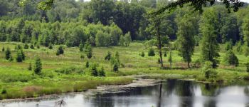
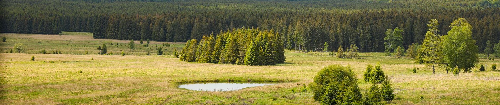
Cette grande boucle tourne autour de la ville de Saint-Hubert.
Elle vous invite à partir à la découverte de milieux et de paysages variés.
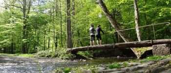
Elle suit la vallée forestière de la Lomme en passant par le Domaine provincial de Mirwart et ses nombreux étangs.
A proximité d’un autre domaine, celui du Fourneau Saint-Michel, elle longe la Masblette au cœur de la forêt domaniale de Saint-Michel-Freyr.
Sur le plateau surplombant la ville de Saint-Hubert, elle relie des sites protégés majeurs comme la réserve du Rouge Poncé ou bien encore plusieurs landes et fagnes offrant de belles vues sur la riche nature environnante.
Points d'intérêt
Localisation
Commentaires
Randonnées à proximité
![Randonnée Marche Saint-Hubert - Saint-Hubert - Les Abanages (SH03) - Photo](https://media.geolcdn.com/t/375/260/ext.jpg?maxdim=2&url=https%3A%2F%2Fservices.sitytrail.com%2FGeolivesWS%2FDownloadMedia.ashx%3FTrailID%3D334550%26Media%3D8af2823f-59d0-452e-b66b-4a477ca4facd.JPG)
![Marche Marche](https://static1.geolcdn.com/sitytour/trail-icons/101.png)
Marche
![](/images/other/stat-length.png)
![](https://static1.geolcdn.com/siteimages/upload/files/16400158638029165_repeat_loop_refresh_sync_direction_icon.png)
![Randonnée Marche Saint-Hubert - Mirwart_Vieux Moulin de Mirwart_Alternative Forêt (SH29 bis) - Photo](https://media.geolcdn.com/t/375/260/ext.jpg?maxdim=2&url=https%3A%2F%2Fservices.sitytrail.com%2FGeolivesWS%2FDownloadMedia.ashx%3FTrailID%3D366988%26Media%3D029a75cb-b10f-4900-87ea-e92327ef26cb.jpg)
![Marche Marche](https://static1.geolcdn.com/sitytour/trail-icons/101.png)
Marche
![](/images/other/stat-length.png)
![](https://static1.geolcdn.com/siteimages/upload/files/16400158638029165_repeat_loop_refresh_sync_direction_icon.png)
![Randonnée Marche Tellin - RL-GG-13_Grupont_Poix-Saint-Hubert - Photo](https://media.geolcdn.com/t/375/260/ext.jpg?maxdim=2&url=https%3A%2F%2Fmedia.geolcdn.com%2Ff%2F5959367f-35e5-42da-bbcc-7bf6a947c3d1.jpg)
![Marche Marche](https://static1.geolcdn.com/sitytour/trail-icons/101.png)
Marche
![](/images/other/stat-length.png)
![](https://static1.geolcdn.com/siteimages/upload/files/16400158638029165_repeat_loop_refresh_sync_direction_icon.png)
![Randonnée Marche Tellin - Balade à Grupont - Photo](https://media.geolcdn.com/t/375/260/ext.jpg?maxdim=2&url=https%3A%2F%2Fservices.sitytrail.com%2FGeolivesWS%2FDownloadMedia.ashx%3FTrailID%3D963883%26Media%3D35fabe2c-0877-4435-b4f9-1ab0863175f9.jpg)
![Marche Marche](https://static1.geolcdn.com/sitytour/trail-icons/101.png)
Marche
![](/images/other/stat-length.png)
![](https://static1.geolcdn.com/siteimages/upload/files/16400158638029165_repeat_loop_refresh_sync_direction_icon.png)
![Randonnée Marche Tellin - Bure - Promenade des chapelles - Photo](https://media.geolcdn.com/t/375/260/ext.jpg?maxdim=2&url=https%3A%2F%2Fservices.sitytrail.com%2FGeolivesWS%2FDownloadMedia.ashx%3FTrailID%3D551016%26Media%3D367a68c9-5f59-4fbe-aa6c-c01d282ce6b9.jpg)
![Marche Marche](https://static1.geolcdn.com/sitytour/trail-icons/101.png)
Marche
![](/images/other/stat-length.png)
![](https://static1.geolcdn.com/siteimages/upload/files/16400158638029165_repeat_loop_refresh_sync_direction_icon.png)
![Randonnée Marche Tellin - Grupont - Promenade du bois de Machi - Photo](https://media.geolcdn.com/t/375/260/ext.jpg?maxdim=2&url=https%3A%2F%2Fservices.sitytrail.com%2FGeolivesWS%2FDownloadMedia.ashx%3FTrailID%3D334604%26Media%3Dcf0f2910-0190-4469-9f88-d94c6a2716b3.jpg)
![Marche Marche](https://static1.geolcdn.com/sitytour/trail-icons/101.png)
Marche
![](/images/other/stat-length.png)
![](https://static1.geolcdn.com/siteimages/upload/files/16400158638029165_repeat_loop_refresh_sync_direction_icon.png)
![Randonnée Marche Tellin - Bure - Promenade du Pont des Cloyes - Photo](https://media.geolcdn.com/t/375/260/ext.jpg?maxdim=2&url=https%3A%2F%2Fservices.sitytrail.com%2FGeolivesWS%2FDownloadMedia.ashx%3FTrailID%3D334602%26Media%3D8e0d2c95-f7df-4bf3-a998-440fe6cfb5b4.jpg)
![Marche Marche](https://static1.geolcdn.com/sitytour/trail-icons/101.png)
Marche
![](/images/other/stat-length.png)
![](https://static1.geolcdn.com/siteimages/upload/files/16400158638029165_repeat_loop_refresh_sync_direction_icon.png)
![Randonnée Marche Saint-Hubert - Mirwart - Marsoult (SH26) - Photo](https://media.geolcdn.com/t/375/260/ext.jpg?maxdim=2&url=https%3A%2F%2Fservices.sitytrail.com%2FGeolivesWS%2FDownloadMedia.ashx%3FTrailID%3D334545%26Media%3Dd3afe587-762b-4377-a558-ad97422cc718.jpg)
![Marche Marche](https://static1.geolcdn.com/sitytour/trail-icons/101.png)
Marche
![](/images/other/stat-length.png)
![](https://static1.geolcdn.com/siteimages/upload/files/16400158638029165_repeat_loop_refresh_sync_direction_icon.png)
![Randonnée V.T.T. Nassogne - Nassogne - Circuit VTT rouge 4 - Photo](https://media.geolcdn.com/t/375/260/ext.jpg?maxdim=2&url=https%3A%2F%2Fservices.sitytrail.com%2FGeolivesWS%2FDownloadMedia.ashx%3FTrailID%3D334498%26Media%3D7e3b25c4-69c3-43b8-9aff-2ac9aa518f72.jpg)
![V.T.T. V.T.T.](https://static1.geolcdn.com/sitytour/trail-icons/202.png)
V.T.T.
![](/images/other/stat-length.png)
![](https://static1.geolcdn.com/siteimages/upload/files/16400158638029165_repeat_loop_refresh_sync_direction_icon.png)