Randonnée Marche Saint-Phal - St-Phal - Photo
 pkermaidic
pkermaidic

Utilisateur

© OpenStreetMap contributors
Longueur
Longueur
7,3 km
Altitude max
Altitude max
257 m
Dénivelé positif
Dénivelé positif
132 m
Km-Effort
Km-Effort  
9,1 km
Altitude min
Altitude min
169 m
Dénivelé négatif
Dénivelé négatif
132 m
Boucle
Boucle
Oui
Date de création :
2017-03-26 00:00:00.0
Dernière modification :
2017-03-26 00:00:00.0

(0 Avis)

Marche
Marche
1h57
Difficulté : Facile

Scannez ce code QR pour ouvrir la randonnée dans l'application SityTrail

Application GPS de randonnée GRATUITE

Logo SityTrail SityTrail

IGN / Instituts géographiques

Télécharger SityTrail sur l'App Store Télécharger SityTrail sur Google Play

Logo SityTrail SityTrail World

Le monde est à vous

Télécharger SityTrail sur l'App Store Télécharger SityTrail sur Google Play Télécharger SityTrail sur Huawei AppGallery

À propos

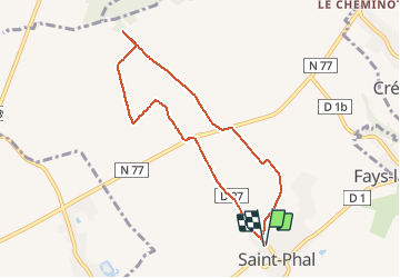
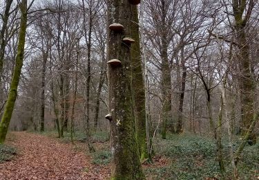
Randonnée Marche de 7,3 km à découvrir à Grand Est, Aube, Saint-Phal. Cette randonnée est proposée par pkermaidic.

Description

petite rando digestive et panoramique aux environs de St-Phal sur des chemins empierrés

Profil altimétrique

Photos

Points d'intérêt

Point d'intérêt Saint-Phal - Point 1 - Photo
pkermaidic
SAINT-PHAL 

Localisation

Pays :
France
Région :
Grand Est
Département/Province :
Aube
Commune :
Saint-Phal
Localité :
Unknown
Départ:(Dec)
Départ:(UTM)
574104 ; 5330407 (31U) N.

Randonnées à proximité

Randonnée Marche Javernant - Javernant (Bon) 12,7km le 12/10/2010 - Photo
Marche
francis1952

Marche

Difficile
(1)
Javernant, Grand Est, Aube, France
12,8 km | 18,1 km-effort
2h 56min
Oui
Randonnée Marche Javernant - Javernant 5 (14,5km) le 30/09/2019 - Photo
Marche
francis1952

Marche

Difficile
(1)
Javernant, Grand Est, Aube, France
14,8 km | 19,9 km-effort
3h 24min
Oui
Randonnée Marche Saint-Phal - Pont aux Verriers 12.2km réel - Photo
Marche
rando-nico

Marche

Facile
(1)
Saint-Phal, Grand Est, Aube, France
12 km | 14,1 km-effort
3h 8min
Oui
Randonnée Marche Jeugny - Jeugny.10.7km réel - Photo
Marche
rando-nico

Marche

Très facile
(1)
Jeugny, Grand Est, Aube, France
10,7 km | 12 km-effort
2h 39min
Oui
Randonnée Marche Sommeval - Sommeval boucle - Photo
Marche
gildascb

Marche

Très facile
Sommeval, Grand Est, Aube, France
7,3 km | 9,5 km-effort
1h 39min
Oui
Randonnée Marche Montigny-les-Monts - Circuit de Coulore - Montigny-les-Monts - Photo
Marche
tracegps

Marche

Moyen
Montigny-les-Monts, Grand Est, Aube, France
8,4 km | 9,7 km-effort
2h 4min
Oui
Randonnée Marche Sommeval - Sommeval 20km le 09.12 2022 - Photo
Marche
francis1952

Marche

Difficile
Sommeval, Grand Est, Aube, France
20 km | 26 km-effort
4h 5min
Oui
Randonnée Marche Sommeval - Sommeval 19km le 29.20.2022 - Photo
Marche
francis1952

Marche

Difficile
Sommeval, Grand Est, Aube, France
19,1 km | 24 km-effort
4h 3min
Oui
Randonnée Marche Javernant - Javernant 15km le 31.01.2022 - Photo
Marche
francis1952

Marche

Difficile
Javernant, Grand Est, Aube, France
15 km | 21 km-effort
3h 13min
Oui


Fermer
Mes abonnements