Trail Walking Saint-Phal - St-Phal - Photo
© OpenStreetMap contributors
Length
Length
7.3 km
Max alt
Max alt
257 m
Uphill gradient
Uphill gradient
132 m
Km-Effort
Km-Effort  
9.1 km
Min alt
Min alt
169 m
Downhill gradient
Downhill gradient
132 m
Boucle
Boucle
Yes
Creation date :
2017-03-26 00:00:00.0
Updated on :
2017-03-26 00:00:00.0

(0 Reviews)

Walking
Walking
1h57
Difficulty : Easy

Scan this QR Code to open this trail in the SityTrail application

FREE GPS app for hiking

Logo SityTrail SityTrail

IGN / Geographical institutes

Download SityTrail from the App Store Download SityTrail from Google Play

Logo SityTrail SityTrail World

The world is yours!

Download SityTrail from the App Store Download SityTrail from Google Play Download SityTrail on Huawei AppGallery

About

Trail Walking of 7.3 km to be discovered at Grand Est, Aube, Saint-Phal. This trail is proposed by pkermaidic.

Description

petite rando digestive et panoramique aux environs de St-Phal sur des chemins empierrés

Elevation profile

Photos

Points of interest

Point of interest Saint-Phal - Point 1 - Photo
pkermaidic
SAINT-PHAL 

Positioning

Country:
France
Region :
Grand Est
Department/Province :
Aube
Municipality :
Saint-Phal
Location:
Unknown
Start:(UTM)
574104 ; 5330407 (31U) N.

Trails nearby

Trail Walking Javernant - Javernant (Bon) 12,7km le 12/10/2010 - Photo
Walking
francis1952

Walking

Difficult
(1)
Javernant, Grand Est, Aube, France
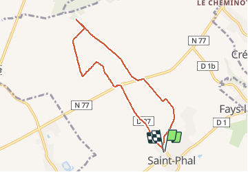
12.8 km | 18.1 km-effort
2h 56min
Yes
Trail Walking Javernant - Javernant 5 (14,5km) le 30/09/2019 - Photo
Walking
francis1952

Walking

Difficult
(1)
Javernant, Grand Est, Aube, France
14.8 km | 19.9 km-effort
3h 24min
Yes
Trail Walking Saint-Phal - Pont aux Verriers 12.2km réel - Photo
Walking
rando-nico

Walking

Easy
(1)
Saint-Phal, Grand Est, Aube, France
12 km | 14.1 km-effort
3h 8min
Yes
Trail Walking Jeugny - Jeugny.10.7km réel - Photo
Walking
rando-nico

Walking

Very easy
(1)
Jeugny, Grand Est, Aube, France
10.7 km | 12 km-effort
2h 39min
Yes
Trail Walking Sommeval - Sommeval boucle - Photo
Walking
gildascb

Walking

Very easy
Sommeval, Grand Est, Aube, France
7.3 km | 9.5 km-effort
1h 39min
Yes
Trail Walking Montigny-les-Monts - Circuit de Coulore - Montigny-les-Monts - Photo
Walking
tracegps

Walking

Medium
Montigny-les-Monts, Grand Est, Aube, France
8.4 km | 9.7 km-effort
2h 4min
Yes
Trail Walking Sommeval - Sommeval 20km le 09.12 2022 - Photo
Walking
francis1952

Walking

Difficult
Sommeval, Grand Est, Aube, France
20 km | 26 km-effort
4h 5min
Yes
Trail Walking Sommeval - Sommeval 19km le 29.20.2022 - Photo
Walking
francis1952

Walking

Difficult
Sommeval, Grand Est, Aube, France
19.1 km | 24 km-effort
4h 3min
Yes
Trail Walking Javernant - Javernant 15km le 31.01.2022 - Photo
Walking
francis1952

Walking

Difficult
Javernant, Grand Est, Aube, France
15 km | 21 km-effort
3h 13min
Yes


Close
My subscriptions