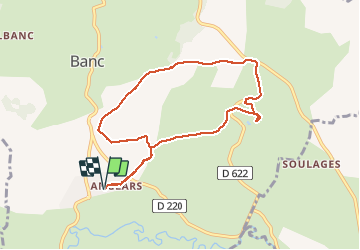
Randonnée Marche Bertholène - les bourines - Photo
 Lacaze
Lacaze

Utilisateur

© OpenStreetMap contributors
Longueur
Longueur
9 km
Altitude max
Altitude max
653 m
Dénivelé positif
Dénivelé positif
152 m
Km-Effort
Km-Effort  
11 km
Altitude min
Altitude min
579 m
Dénivelé négatif
Dénivelé négatif
154 m
Boucle
Boucle
Oui
Date de création :
2014-12-10 00:00:00.0
Dernière modification :
2014-12-10 00:00:00.0

(1 Avis)

Marche
Marche
2h33
Difficulté : Facile

Scannez ce code QR pour ouvrir la randonnée dans l'application SityTrail

Application GPS de randonnée GRATUITE

Logo SityTrail SityTrail

IGN / Instituts géographiques

Télécharger SityTrail sur l'App Store Télécharger SityTrail sur Google Play

Logo SityTrail SityTrail World

Le monde est à vous

Télécharger SityTrail sur l'App Store Télécharger SityTrail sur Google Play Télécharger SityTrail sur Huawei AppGallery

À propos

Randonnée Marche de 9 km à découvrir à Occitanie, Aveyron, Bertholène. Cette randonnée est proposée par Lacaze.

Description

depart Anglais

Profil altimétrique

Photos

Localisation

Pays :
France
Région :
Occitanie
Département/Province :
Aveyron
Commune :
Bertholène
Localité :
Unknown
Départ:(Dec)
Départ:(UTM)
482672 ; 4917466 (31T) N.

Commentaires

Veuillez vous connecter pour laisser un commentaire ou une note


Randonnées à proximité

Randonnée Marche Bertholène - les bourines - Photo
Marche
Lacaze

Marche

Facile
Bertholène, Occitanie, Aveyron, France
9 km | 11 km-effort
2h 33min
Oui
Randonnée Marche Bozouls - Horizons et Clochers du Rouergue - Gillorgues - Photo
Marche
tracegps

Marche

Moyen
Bozouls, Occitanie, Aveyron, France
11,9 km | 15,5 km-effort
3h 0min
Oui
Randonnée Marche Bertholène - Tour du village de Bertholène - Photo
Marche
tracegps

Marche

Facile
Bertholène, Occitanie, Aveyron, France
1 km | 1,5 km-effort
30min
Oui
Randonnée Marche Laissac-Sévérac l'Église - Tour du village de Laissac  - Photo
Marche
tracegps

Marche

Facile
Laissac-Sévérac l'Église, Occitanie, Aveyron, France
1,6 km | 1,9 km-effort
30min
Oui
Randonnée V.T.T. Bertholène - bertholene bozouls Saint Côme  - Photo
V.T.T.
limo12

V.T.T.

Facile
Bertholène, Occitanie, Aveyron, France
29 km | 35 km-effort
2h 23min
Non
Randonnée Marche Bozouls - Aboul /Bozouls - Photo
Marche
Strabidja

Marche

Facile
Bozouls, Occitanie, Aveyron, France
3,2 km | 4,3 km-effort
54min
Oui
Randonnée V.T.T. Gabriac - Gabriac/Cruejouls VTT - Photo
V.T.T.
Strabidja

V.T.T.

Facile
Gabriac, Occitanie, Aveyron, France
13 km | 16,3 km-effort
1h 30min
Oui
Randonnée Marche Gabriac - Les 5 clochers - Photo
Marche
bbertrand974

Marche

Facile
Gabriac, Occitanie, Aveyron, France
11,6 km | 14,4 km-effort
3h 7min
Oui
Randonnée V.T.T. Bertholène - ancienne voie ferrée - Photo
V.T.T.
bbertrand974

V.T.T.

Très facile
Bertholène, Occitanie, Aveyron, France
22 km | 26 km-effort
1h 42min
Non


Fermer
Mes abonnements