Randonnée V.T.T. Serrières-sur-Ain - merpuis merloz crêtes chambod poncin cizod  - Photo

merpuis merloz crêtes chambod poncin cizod

 jujube007
jujube007

Utilisateur

© OpenStreetMap contributors
Longueur
Longueur
26 km
Altitude max
Altitude max
517 m
Dénivelé positif
Dénivelé positif
708 m
Km-Effort
Km-Effort  
36 km
Altitude min
Altitude min
253 m
Dénivelé négatif
Dénivelé négatif
708 m
Boucle
Boucle
Oui
Date de création :
2020-06-14 07:12:21.933
Dernière modification :
2020-06-15 08:32:27.193

(0 Avis)

V.T.T.
V.T.T.
2h30
Difficulté : Moyen

Scannez ce code QR pour ouvrir la randonnée dans l'application SityTrail

Application GPS de randonnée GRATUITE

Logo SityTrail SityTrail

IGN / Instituts géographiques

Télécharger SityTrail sur l'App Store Télécharger SityTrail sur Google Play

Logo SityTrail SityTrail World

Le monde est à vous

Télécharger SityTrail sur l'App Store Télécharger SityTrail sur Google Play Télécharger SityTrail sur Huawei AppGallery

À propos

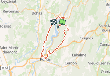
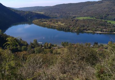
Randonnée V.T.T. de 26 km à découvrir à Auvergne-Rhône-Alpes, Ain, Serrières-sur-Ain. Cette randonnée est proposée par jujube007.

Description

Single raid féminin pas entretenu, bcp de ronces et aubépines, ça pique.

Profil altimétrique

Localisation

Pays :
France
Région :
Auvergne-Rhône-Alpes
Département/Province :
Ain
Commune :
Serrières-sur-Ain
Localité :
Unknown
Départ:(UTM)
688166 ; 5111789 (31T) N.

Randonnées à proximité

Randonnée Marche Challes-la-Montagne - challes la montagne barrage lallement la cueille sameriat - Photo
Marche
loca.yves

Marche

Facile
Challes-la-Montagne, Auvergne-Rhône-Alpes, Ain, France
10 km | 14,3 km-effort
3h 10min
Oui
Randonnée Marche Poncin - La Cueille - Cizod  - Photo
Marche
Jackoyo

Marche

Moyen
Poncin, Auvergne-Rhône-Alpes, Ain, France
8,6 km | 12,8 km-effort
1h 56min
Oui
Randonnée Marche Poncin - Poncin Jujurieux  - Photo
Marche
Jackoyo

Marche

Facile
Poncin, Auvergne-Rhône-Alpes, Ain, France
17 km | 22 km-effort
3h 28min
Oui
Randonnée Marche Serrières-sur-Ain - Serrières Leyssard - Photo
Marche
Jackoyo

Marche

Difficile
Serrières-sur-Ain, Auvergne-Rhône-Alpes, Ain, France
16,6 km | 26 km-effort
4h 2min
Oui
Randonnée V.T.T. Serrières-sur-Ain - merpuis-crêtes chambod-estables-challes - Photo
V.T.T.
jujube007

V.T.T.

Difficile
Serrières-sur-Ain, Auvergne-Rhône-Alpes, Ain, France
39 km | 53 km-effort
3h 15min
Oui
Randonnée Cyclotourisme Serrières-sur-Ain - Serrières --> Les rousses j1 - Photo
Cyclotourisme
Nicolas Bajard

Cyclotourisme

Très facile
Serrières-sur-Ain, Auvergne-Rhône-Alpes, Ain, France
105 km | 144 km-effort
6h 0min
Non
Randonnée Marche Poncin - La Cueille-Belvédère des Roches-Ain - Photo
Marche
ThierryJ01

Marche

Moyen
Poncin, Auvergne-Rhône-Alpes, Ain, France
5 km | 8,4 km-effort
1h 43min
Oui
Randonnée Marche Poncin - poncin - Photo
Marche
montagnes

Marche

Très facile
Poncin, Auvergne-Rhône-Alpes, Ain, France
5,1 km | 7,1 km-effort
1h 45min
Non
Randonnée Marche Serrières-sur-Ain - Serrieres Merpuis Sonthonnax le vignoble  - Photo
Marche
HB01

Marche

Moyen
Serrières-sur-Ain, Auvergne-Rhône-Alpes, Ain, France
16,7 km | 25 km-effort
5h 20min
Oui


Fermer
Mes abonnements