Trail Mountain bike Serrières-sur-Ain - merpuis merloz crêtes chambod poncin cizod  - Photo

merpuis merloz crêtes chambod poncin cizod

© OpenStreetMap contributors
Length
Length
26 km
Max alt
Max alt
517 m
Uphill gradient
Uphill gradient
708 m
Km-Effort
Km-Effort  
36 km
Min alt
Min alt
253 m
Downhill gradient
Downhill gradient
708 m
Boucle
Boucle
Yes
Creation date :
2020-06-14 07:12:21.933
Updated on :
2020-06-15 08:32:27.193

(0 Reviews)

Mountain bike
Mountain bike
2h30
Difficulty : Medium

Scan this QR Code to open this trail in the SityTrail application

FREE GPS app for hiking

Logo SityTrail SityTrail

IGN / Geographical institutes

Download SityTrail from the App Store Download SityTrail from Google Play

Logo SityTrail SityTrail World

The world is yours!

Download SityTrail from the App Store Download SityTrail from Google Play Download SityTrail on Huawei AppGallery

About

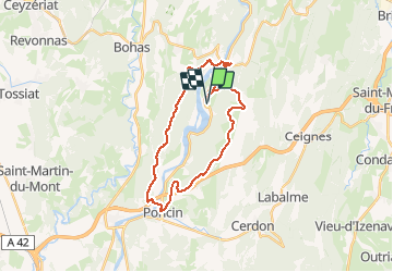
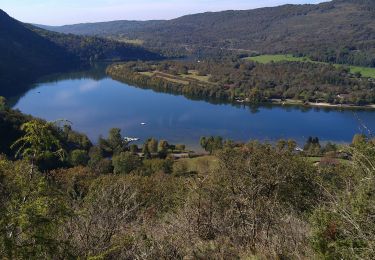
Trail Mountain bike of 26 km to be discovered at Auvergne-Rhône-Alpes, Ain, Serrières-sur-Ain. This trail is proposed by jujube007.

Description

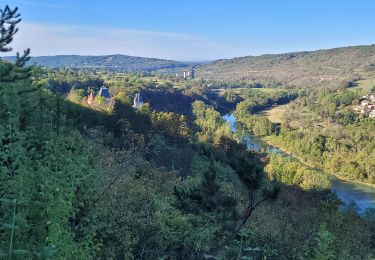
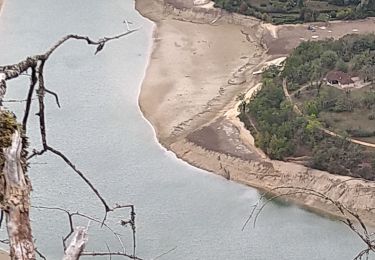
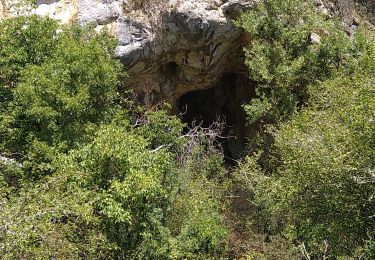
Single raid féminin pas entretenu, bcp de ronces et aubépines, ça pique.

Elevation profile

Positioning

Country:
France
Region :
Auvergne-Rhône-Alpes
Department/Province :
Ain
Municipality :
Serrières-sur-Ain
Location:
Unknown
Start:(UTM)
688166 ; 5111789 (31T) N.

Trails nearby

Trail Walking Challes-la-Montagne - challes la montagne barrage lallement la cueille sameriat - Photo
Walking
loca.yves

Walking

Easy
Challes-la-Montagne, Auvergne-Rhône-Alpes, Ain, France
10 km | 14.3 km-effort
3h 10min
Yes
Trail Walking Poncin - La Cueille - Cizod  - Photo
Walking
Jackoyo

Walking

Medium
Poncin, Auvergne-Rhône-Alpes, Ain, France
8.6 km | 12.8 km-effort
1h 56min
Yes
Trail Walking Poncin - Poncin Jujurieux  - Photo
Walking
Jackoyo

Walking

Easy
Poncin, Auvergne-Rhône-Alpes, Ain, France
17 km | 22 km-effort
3h 28min
Yes
Trail Walking Serrières-sur-Ain - Serrières Leyssard - Photo
Walking
Jackoyo

Walking

Difficult
Serrières-sur-Ain, Auvergne-Rhône-Alpes, Ain, France
16.6 km | 26 km-effort
4h 2min
Yes
Trail Mountain bike Serrières-sur-Ain - merpuis-crêtes chambod-estables-challes - Photo
Mountain bike
jujube007

Mountain bike

Difficult
Serrières-sur-Ain, Auvergne-Rhône-Alpes, Ain, France
39 km | 53 km-effort
3h 15min
Yes
Trail Bicycle tourism Serrières-sur-Ain - Serrières --> Les rousses j1 - Photo
Bicycle tourism
Nicolas Bajard

Bicycle tourism

Very easy
Serrières-sur-Ain, Auvergne-Rhône-Alpes, Ain, France
105 km | 144 km-effort
6h 0min
No
Trail Walking Poncin - La Cueille-Belvédère des Roches-Ain - Photo
Walking
ThierryJ01

Walking

Medium
Poncin, Auvergne-Rhône-Alpes, Ain, France
5 km | 8.4 km-effort
1h 43min
Yes
Trail Walking Poncin - poncin - Photo
Walking
montagnes

Walking

Very easy
Poncin, Auvergne-Rhône-Alpes, Ain, France
5.1 km | 7.1 km-effort
1h 45min
No
Trail Walking Serrières-sur-Ain - Serrieres Merpuis Sonthonnax le vignoble  - Photo
Walking
HB01

Walking

Medium
Serrières-sur-Ain, Auvergne-Rhône-Alpes, Ain, France
16.7 km | 25 km-effort
5h 20min
Yes


Close
My subscriptions