Randonnée Marche Masevaux-Niederbruck - Masevaux - Rossberg par le belvédère du Fuchsfelsen - Photo

Masevaux - Rossberg par le belvédère du Fuchsfelsen

 Bart2015
Bart2015

Utilisateur

© OpenStreetMap contributors
Longueur
Longueur
19,9 km
Altitude max
Altitude max
1185 m
Dénivelé positif
Dénivelé positif
1027 m
Km-Effort
Km-Effort  
34 km
Altitude min
Altitude min
405 m
Dénivelé négatif
Dénivelé négatif
1025 m
Boucle
Boucle
Oui
Date de création :
2020-09-14 08:20:56.814
Dernière modification :
2020-09-14 15:11:53.944

(1 Avis)

Marche
Marche
4h44
Difficulté : Moyen

Scannez ce code QR pour ouvrir la randonnée dans l'application SityTrail

Application GPS de randonnée GRATUITE

Logo SityTrail SityTrail

IGN / Instituts géographiques

Télécharger SityTrail sur l'App Store Télécharger SityTrail sur Google Play

Logo SityTrail SityTrail World

Le monde est à vous

Télécharger SityTrail sur l'App Store Télécharger SityTrail sur Google Play Télécharger SityTrail sur Huawei AppGallery

À propos

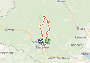
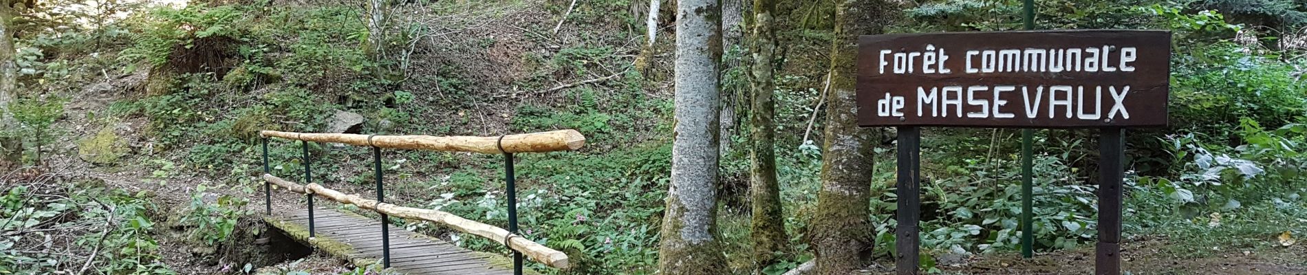
Randonnée Marche de 19,9 km à découvrir à Grand Est, Haut-Rhin, Masevaux-Niederbruck. Cette randonnée est proposée par Bart2015.

Description

Randonnée sportive avec de magnifiques vues sur le Ballon d'Alsace, le Grand Ballon, ... Petite pause au sommet du Rossberg. A ne pas manquer au retour, l'impressionnant Rocher du Corbeau ...
Bonne randonnée.

Profil altimétrique

Photos

40 photos au total. Cliquez sur une photo pour les afficher toutes dans la galerie.

Localisation

Pays :
France
Région :
Grand Est
Département/Province :
Haut-Rhin
Commune :
Masevaux-Niederbruck
Localité :
Masevaux
Départ:(UTM)
350194 ; 5293364 (32T) N.

Commentaires

Veuillez vous connecter pour laisser un commentaire ou une note


Merci pour le partage. Je la mets dans mes favoris sur SityTrail.


Randonnées à proximité

Randonnée Marche Sentheim - Sentheim Rossberg - Photo
Marche
helmut68

Marche

Moyen
(1)
Sentheim, Grand Est, Haut-Rhin, France
27 km | 40 km-effort
6h 11min
Oui
Randonnée Marche Bourbach-le-Haut - Tour du Rossberg - Gsang - Thannerhubel - Photo
Marche
GUIDE
mumu.larandonneuse

Marche

Difficile
Bourbach-le-Haut, Grand Est, Haut-Rhin, France
11,4 km | 18,5 km-effort
4h 12min
Oui
Randonnée Marche Lauw - 2022-07-14 Marche Lauw Refuge CAF Baerenkopf - Photo
Marche
GUIDE
holtzv

Marche

Très difficile
Lauw, Grand Est, Haut-Rhin, France
18,4 km | 31 km-effort
5h 35min
Non
Randonnée A pied Sentheim - Sentier géologique du Wolfloch - Photo
A pied
PRO

A pied

Facile
Sentheim, Grand Est, Haut-Rhin, France
3,8 km | 4,8 km-effort
1h 5min
Non
Randonnée A pied Sentheim - Sentheim - Bergwald - Eichwald - Guevenheim - Sentheim - Photo
A pied
patrickbeyrath

A pied

Facile
(1)
Sentheim, Grand Est, Haut-Rhin, France
13,4 km | 16,6 km-effort
Inconnu
Oui
Randonnée Marche Bitschwiller-lès-Thann - 68 Col du Hundsrück  - FA Gsang - retour ThannerHubel - Photo
Marche

Marche

Moyen
(1)
Bitschwiller-lès-Thann, Grand Est, Haut-Rhin, France
11,2 km | 18,4 km-effort
3h 48min
Oui
Randonnée Marche Masevaux-Niederbruck - Rando CLAS du 25/04/2024 - Photo
Marche
boubou68

Marche

Très difficile
Masevaux-Niederbruck, Grand Est, Haut-Rhin, France
17 km | 28 km-effort
4h 24min
Oui
Randonnée Marche Kirchberg - Rando du 11/04/2024  ..Marcheurs - Photo
Marche
boubou68

Marche

Très difficile
Kirchberg, Grand Est, Haut-Rhin, France
23 km | 37 km-effort
5h 37min
Oui
Randonnée Marche Sentheim - Knapphutte Saegenkopf Hütte - Photo
Marche
helmut68

Marche

Moyen
Sentheim, Grand Est, Haut-Rhin, France
13,8 km | 17,2 km-effort
5h 11min
Oui


Fermer
Mes abonnements