Randonnée A pied Pontécoulant - Pontecoulant - Photo

ensemble sur les chemins

© OpenStreetMap contributors
Longueur
Longueur
4,3 km
Altitude max
Altitude max
241 m
Dénivelé positif
Dénivelé positif
124 m
Km-Effort
Km-Effort  
6 km
Altitude min
Altitude min
134 m
Dénivelé négatif
Dénivelé négatif
122 m
Boucle
Boucle
Oui
Date de création :
2020-09-22 13:02:13.032
Dernière modification :
2020-09-22 13:06:31.965

(0 Avis)

A pied
A pied
--
Difficulté : Moyen

Scannez ce code QR pour ouvrir la randonnée dans l'application SityTrail

Application GPS de randonnée GRATUITE

Logo SityTrail SityTrail

IGN / Instituts géographiques

Télécharger SityTrail sur l'App Store Télécharger SityTrail sur Google Play

Logo SityTrail SityTrail World

Le monde est à vous

Télécharger SityTrail sur l'App Store Télécharger SityTrail sur Google Play Télécharger SityTrail sur Huawei AppGallery

À propos

Randonnée A pied de 4,3 km à découvrir à Normandie, Calvados, Pontécoulant. Cette randonnée est proposée par AACLARANDO.

Description

départ du chateau de Pontecoulant. Direction le point de vue, puis l'Aitre, le Bosq Hamon et retour le chareau.

Profil altimétrique

Localisation

Pays :
France
Région :
Normandie
Département/Province :
Calvados
Commune :
Pontécoulant
Localité :
Unknown
Départ:(UTM)
676562 ; 5418769 (30U) N.

Randonnées à proximité

Randonnée A pied Condé-en-Normandie - La Chapelle Engerbold - Photo
A pied
PRO

A pied

Facile
Condé-en-Normandie, Normandie, Calvados, France
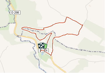
4,3 km | 5,8 km-effort
1h 18min
Oui
Randonnée A pied Terres de Druance - Le Moulin du Boeuf - Photo
A pied
PRO

A pied

Facile
Terres de Druance, Normandie, Calvados, France
6,1 km | 7,9 km-effort
1h 47min
Oui
Randonnée A pied Terres de Druance - Tour du Bourg - Photo
A pied
PRO

A pied

Facile
Terres de Druance, Normandie, Calvados, France
3,3 km | 4,2 km-effort
57min
Oui
Randonnée A pied Condé-en-Normandie - Sur les Traces de la Dame Blanche - Photo
A pied
PRO

A pied

Facile
Condé-en-Normandie, Normandie, Calvados, France
3,2 km | 4,2 km-effort
56min
Non
Randonnée A pied Condé-en-Normandie - Vallée de la Druance - Photo
A pied
PRO

A pied

Facile
Condé-en-Normandie, Normandie, Calvados, France
4,1 km | 5,2 km-effort
1h 11min
Non
Randonnée A pied Condé-en-Normandie - A la Découverte des
A pied
PRO

A pied

Facile
Condé-en-Normandie, Normandie, Calvados, France
10,4 km | 13,6 km-effort
3h 5min
Oui
Randonnée A pied La Villette - Vers la
A pied
PRO

A pied

Facile
La Villette, Normandie, Calvados, France
4,5 km | 6,3 km-effort
1h 25min
Oui
Randonnée A pied Condé-en-Normandie - Chemins Creux E - Photo
A pied
PRO

A pied

Facile
Condé-en-Normandie, Normandie, Calvados, France
6,6 km | 8,2 km-effort
1h 51min
Oui
Randonnée A pied Périgny - Chemins Creux C - Photo
A pied
PRO

A pied

Facile
Périgny, Normandie, Calvados, France
4,2 km | 5,1 km-effort
1h 10min
Oui


Fermer
Mes abonnements