Tocht Te voet Pontécoulant - Pontecoulant - Photo

ensemble sur les chemins

© OpenStreetMap contributors
Lengte
Lengte
4,3 km
Max. hoogte
Max. hoogte
241 m
Positief hoogteverschil
124 m
Km-Effort
Km-Effort  
6 km
Min. hoogte
Min. hoogte
134 m
Negatief hoogteverschil
122 m
Boucle
Boucle
Ja
Datum van aanmaak :
2020-09-22 13:02:13.032
Laatste wijziging :
2020-09-22 13:06:31.965

(0 Bericht)

Te voet
Te voet
--
Moeilijkheid : Medium

Scan deze QR-code om de tocht te openen in de SityTrail-applicatie

Gratisgps-wandelapplicatie

Logo SityTrail SityTrail

IGN / Geografische instituten

SityTrail uit de App Store downloaden SityTrail uit Google Play downloaden

Logo SityTrail SityTrail World

De wereld gaat voor u open

SityTrail uit de App Store downloaden SityTrail uit Google Play downloaden SityTrail op Huawei AppGallery downloaden

Over ons

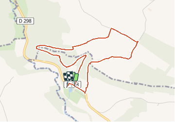
Tocht Te voet van 4,3 km beschikbaar op Normandië, Calvados, Pontécoulant. Deze tocht wordt voorgesteld door AACLARANDO.

Beschrijving

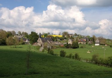
départ du chateau de Pontecoulant. Direction le point de vue, puis l'Aitre, le Bosq Hamon et retour le chareau.

Hoogteprofiel

Plaatsbepaling

Land:
France
Regio :
Normandië
Departement/Provincie :
Calvados
Gemeente :
Pontécoulant
Locatie:
Unknown
Vertrek:(UTM)
676562 ; 5418769 (30U) N.

Wandeltochten in de omgeving

Tocht Te voet Condé-en-Normandie - La Chapelle Engerbold - Photo
Te voet
PRO

Te voet

Gemakkelijk
Condé-en-Normandie, Normandië, Calvados, France
4,3 km | 5,8 km-effort
1h 18min
Ja
Tocht Te voet Terres de Druance - Le Moulin du Boeuf - Photo
Te voet
PRO

Te voet

Gemakkelijk
Terres de Druance, Normandië, Calvados, France
6,1 km | 7,9 km-effort
1h 47min
Ja
Tocht Te voet Terres de Druance - Tour du Bourg - Photo
Te voet
PRO

Te voet

Gemakkelijk
Terres de Druance, Normandië, Calvados, France
3,3 km | 4,2 km-effort
57min
Ja
Tocht Te voet Condé-en-Normandie - Sur les Traces de la Dame Blanche - Photo
Te voet
PRO

Te voet

Gemakkelijk
Condé-en-Normandie, Normandië, Calvados, France
3,2 km | 4,2 km-effort
56min
Neen
Tocht Te voet Condé-en-Normandie - Vallée de la Druance - Photo
Te voet
PRO

Te voet

Gemakkelijk
Condé-en-Normandie, Normandië, Calvados, France
4,1 km | 5,2 km-effort
1h 11min
Neen
Tocht Te voet Condé-en-Normandie - A la Découverte des
Te voet
PRO

Te voet

Gemakkelijk
Condé-en-Normandie, Normandië, Calvados, France
10,4 km | 13,6 km-effort
3h 5min
Ja
Tocht Te voet La Villette - Vers la
Te voet
PRO

Te voet

Gemakkelijk
La Villette, Normandië, Calvados, France
4,5 km | 6,3 km-effort
1h 25min
Ja
Tocht Te voet Condé-en-Normandie - Chemins Creux E - Photo
Te voet
PRO

Te voet

Gemakkelijk
Condé-en-Normandie, Normandië, Calvados, France
6,6 km | 8,2 km-effort
1h 51min
Ja
Tocht Te voet Périgny - Chemins Creux C - Photo
Te voet
PRO

Te voet

Gemakkelijk
Périgny, Normandië, Calvados, France
4,2 km | 5,1 km-effort
1h 10min
Ja


Sluiten
Mijn abonnementen