Randonnée Marche Congénies - Contenues 2 - Photo
 G.DAUMET
G.DAUMET

Utilisateur

© OpenStreetMap contributors
Longueur
Longueur
10,8 km
Altitude max
Altitude max
136 m
Dénivelé positif
Dénivelé positif
159 m
Km-Effort
Km-Effort  
12,9 km
Altitude min
Altitude min
53 m
Dénivelé négatif
Dénivelé négatif
158 m
Boucle
Boucle
Oui
Date de création :
2021-05-13 12:12:09.024
Dernière modification :
2021-05-14 07:28:25.546

(0 Avis)

Marche
Marche
18h56
Difficulté : Facile

Scannez ce code QR pour ouvrir la randonnée dans l'application SityTrail

Application GPS de randonnée GRATUITE

Logo SityTrail SityTrail

IGN / Instituts géographiques

Télécharger SityTrail sur l'App Store Télécharger SityTrail sur Google Play

Logo SityTrail SityTrail World

Le monde est à vous

Télécharger SityTrail sur l'App Store Télécharger SityTrail sur Google Play Télécharger SityTrail sur Huawei AppGallery

À propos

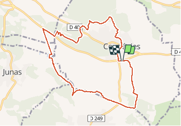
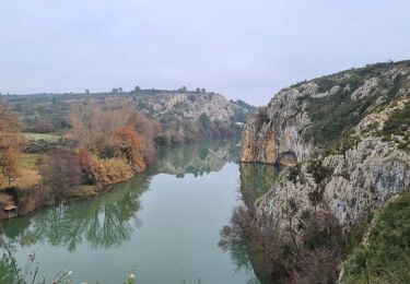
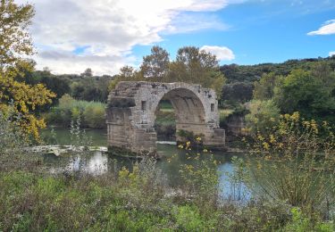
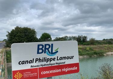
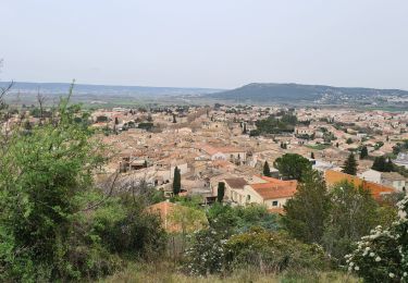
Randonnée Marche de 10,8 km à découvrir à Occitanie, Gard, Congénies. Cette randonnée est proposée par G.DAUMET.

Description

La même mais passage par le terrain de foot.

Profil altimétrique

Localisation

Pays :
France
Région :
Occitanie
Département/Province :
Gard
Commune :
Congénies
Localité :
Unknown
Départ:(UTM)
593395 ; 4847372 (31T) N.

Randonnées à proximité

Randonnée V.T.T. Calvisson - Espace VTT-FFC Pays de Sommières n°7 - Les Châteaux du Sommiérois - Photo
V.T.T.
tracegps

V.T.T.

Difficile
(1)
Calvisson, Occitanie, Gard, France
42 km | 50 km-effort
3h 30min
Oui
Randonnée Marche Junas - Entre Junas et Aujargues - Photo
Marche
GUIDE
randotines

Marche

Facile
Junas, Occitanie, Gard, France
7,9 km | 9,4 km-effort
2h 2min
Oui
Randonnée Marche Junas - Aubais  - Photo
Marche
Galoche

Marche

Très facile
Junas, Occitanie, Gard, France
6,4 km | 7,8 km-effort
1h 39min
Oui
Randonnée Marche Congénies - congenies-lemazet-calvisson - Photo
Marche
v.rabot

Marche

Moyen
Congénies, Occitanie, Gard, France
16,9 km | 21 km-effort
5h 0min
Oui
Randonnée Marche Aubais - Aubais-junas-moulin_de_corbières - Photo
Marche
v.rabot

Marche

Moyen
Aubais, Occitanie, Gard, France
15,5 km | 18,3 km-effort
5h 0min
Oui
Randonnée Marche Villetelle - villetelle  - Photo
Marche
v.rabot

Marche

Facile
Villetelle, Occitanie, Hérault, France
6,6 km | 7,9 km-effort
1h 34min
Oui
Randonnée Marche Aubais - moulin-carriere-gallargues - Photo
Marche
v.rabot

Marche

Facile
Aubais, Occitanie, Gard, France
12,5 km | 14,1 km-effort
2h 30min
Oui
Randonnée Marche Villetelle - Sensei pascal  - Photo
Marche
rio34740

Marche

Moyen
Villetelle, Occitanie, Hérault, France
17,7 km | 0 m-effort
5h 17min
Oui
Randonnée Marche Congénies - Congenies-Mazet-Sincans-Calvisson - Photo
Marche
v.rabot

Marche

Moyen
Congénies, Occitanie, Gard, France
18 km | 23 km-effort
5h 30min
Oui


Fermer
Mes abonnements