Randonnée Marche nordique Gensac-la-Pallue - Vignobles du Cognac au départ de Gensac-la-Pallue - Photo

Vignobles du Cognac au départ de Gensac-la-Pallue

 denissculier
denissculier

Utilisateur

© OpenStreetMap contributors
Longueur
Longueur
11,3 km
Altitude max
Altitude max
36 m
Dénivelé positif
Dénivelé positif
61 m
Km-Effort
Km-Effort  
12,1 km
Altitude min
Altitude min
14 m
Dénivelé négatif
Dénivelé négatif
61 m
Boucle
Boucle
Oui
Date de création :
2021-07-04 12:59:27.674
Dernière modification :
2021-07-04 13:20:08.646

(0 Avis)

Marche nordique
Marche nordique
2h45
Difficulté : Moyen

Scannez ce code QR pour ouvrir la randonnée dans l'application SityTrail

Application GPS de randonnée GRATUITE

Logo SityTrail SityTrail

IGN / Instituts géographiques

Télécharger SityTrail sur l'App Store Télécharger SityTrail sur Google Play

Logo SityTrail SityTrail World

Le monde est à vous

Télécharger SityTrail sur l'App Store Télécharger SityTrail sur Google Play Télécharger SityTrail sur Huawei AppGallery

À propos

Randonnée Marche nordique de 11,3 km à découvrir à Nouvelle-Aquitaine, Charente, Gensac-la-Pallue. Cette randonnée est proposée par denissculier.

Profil altimétrique

Localisation

Pays :
France
Région :
Nouvelle-Aquitaine
Département/Province :
Charente
Commune :
Gensac-la-Pallue
Localité :
Unknown
Départ:(UTM)
714127 ; 5059092 (30T) N.

Randonnées à proximité

Randonnée Marche Bourg-Charente - Bourg Charente - Photo
Marche
alainjoseph6

Marche

Très facile
Bourg-Charente, Nouvelle-Aquitaine, Charente, France
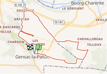
12,4 km | 13,9 km-effort
3h 3min
Oui
Randonnée Marche Saint-Brice - entre vignes et Charente  - Photo
Marche
viam19

Marche

Facile
Saint-Brice, Nouvelle-Aquitaine, Charente, France
16,1 km | 18,1 km-effort
4h 47min
Oui
Randonnée Marche Saint-Brice - Saint Brice - Photo
Marche
boivin101

Marche

Facile
Saint-Brice, Nouvelle-Aquitaine, Charente, France
9,9 km | 11,5 km-effort
3h 1min
Oui
Randonnée Marche Bourg-Charente - Bourg-Charente Jarnac aller-retour - Photo
Marche
boulesteix

Marche

Facile
Bourg-Charente, Nouvelle-Aquitaine, Charente, France
9,1 km | 9,8 km-effort
1h 48min
Oui
Randonnée Marche Mainxe-Gondeville - mainxe - Photo
Marche
sy!

Marche

Très facile
Mainxe-Gondeville, Nouvelle-Aquitaine, Charente, France
12,5 km | 14 km-effort
2h 50min
Oui
Randonnée Vélo de route Mainxe-Gondeville - chez Roland billard Saint-Preuil - Photo
Vélo de route
boulesteix

Vélo de route

Moyen
Mainxe-Gondeville, Nouvelle-Aquitaine, Charente, France
28 km | 32 km-effort
1h 14min
Oui
Randonnée Marche Bourg-Charente - bourg bis - Photo
Marche
dorcier

Marche

Très facile
Bourg-Charente, Nouvelle-Aquitaine, Charente, France
11,9 km | 13,2 km-effort
2h 43min
Oui
Randonnée Marche Bourg-Charente - Bourg-Charente - Photo
Marche
dorcier

Marche

Très facile
Bourg-Charente, Nouvelle-Aquitaine, Charente, France
12,6 km | 14 km-effort
3h 0min
Oui
Randonnée Marche Segonzac - Autour de Segonzac  - Photo
Marche
jmrobin

Marche

Moyen
Segonzac, Nouvelle-Aquitaine, Charente, France
14,6 km | 17,1 km-effort
2h 59min
Oui


Fermer
Mes abonnements