Randonnée Marche Saint-Chéron - Saint Chéron Héliomonde château de Blaville La Tuilerie - Photo

Saint Chéron Héliomonde château de Blaville La Tuilerie

 jll7513
jll7513

Utilisateur

© OpenStreetMap contributors
Longueur
Longueur
11,2 km
Altitude max
Altitude max
155 m
Dénivelé positif
Dénivelé positif
241 m
Km-Effort
Km-Effort  
14,4 km
Altitude min
Altitude min
61 m
Dénivelé négatif
Dénivelé négatif
240 m
Boucle
Boucle
Non
Date de création :
2021-07-30 08:55:28.0
Dernière modification :
2021-07-30 18:54:45.495

(0 Avis)

Marche
Marche
3h15
Difficulté : Facile
Marche nordique
Marche nordique
2h02
Difficulté : Facile

Scannez ce code QR pour ouvrir la randonnée dans l'application SityTrail

Application GPS de randonnée GRATUITE

Logo SityTrail SityTrail

IGN / Instituts géographiques

Télécharger SityTrail sur l'App Store Télécharger SityTrail sur Google Play

Logo SityTrail SityTrail World

Le monde est à vous

Télécharger SityTrail sur l'App Store Télécharger SityTrail sur Google Play Télécharger SityTrail sur Huawei AppGallery

À propos

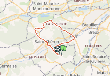
Randonnée Marche de 11,2 km à découvrir à Île-de-France, Essonne, Saint-Chéron. Cette randonnée est proposée par jll7513.

Description

On peut se parquer sur le parking du camping du Parc des Roches. Le chemin démarre entre les deux entrées des campings. Parcours très sympa avec de très beaux sentiers en forêt. On peut voir en chemin là Tour Gabrielle et le château de Blaville.

Profil altimétrique

Photos

Localisation

Pays :
France
Région :
Île-de-France
Département/Province :
Essonne
Commune :
Saint-Chéron
Localité :
Unknown
Départ:(Dec)
Départ:(UTM)
436405 ; 5377154 (31U) N.

Randonnées à proximité

Randonnée Marche Saint-Sulpice-de-Favières - Les Pétales de Souzy - Photo
Marche
tracegps

Marche

Difficile
(1)
Saint-Sulpice-de-Favières, Île-de-France, Essonne, France
23 km | 29 km-effort
4h 49min
Oui
Randonnée A pied Saint-Yon - Sur les traces de la Renarde - Photo
A pied
PRO

A pied

Très difficile
Saint-Yon, Île-de-France, Essonne, France
38 km | 44 km-effort
10h 4min
Non
Randonnée Marche Saint-Sulpice-de-Favières - St Sulpice - Photo
Marche
Auger91

Marche

Moyen
(1)
Saint-Sulpice-de-Favières, Île-de-France, Essonne, France
8 km | 10,1 km-effort
2h 18min
Oui
Randonnée Marche Sermaise - 2018-09-26 Rando Sermaise - Photo
Marche
jchezlemas

Marche

Facile
(1)
Sermaise, Île-de-France, Essonne, France
12,3 km | 15 km-effort
3h 15min
Oui
Randonnée Marche Villeconin - Villeconin - Photo
Marche
guydu41

Marche

Moyen
Villeconin, Île-de-France, Essonne, France
8,5 km | 10,9 km-effort
2h 11min
Oui
Randonnée Marche Saint-Sulpice-de-Favières - Saint-Sulpice-de-Favières - Photo
Marche
guydu41

Marche

Moyen
Saint-Sulpice-de-Favières, Île-de-France, Essonne, France
7,5 km | 9,4 km-effort
1h 55min
Oui
Randonnée Marche Souzy-la-Briche - Carrières de Madagascar à Souzy-la-Briche  - Photo
Marche
guydu41

Marche

Moyen
Souzy-la-Briche, Île-de-France, Essonne, France
6,8 km | 8,3 km-effort
1h 52min
Oui
Randonnée Marche Saint-Maurice-Montcouronne - Boucle St Maurice Montcouronne - Brigitte - Photo
Marche
chessyca

Marche

Très facile
Saint-Maurice-Montcouronne, Île-de-France, Essonne, France
21 km | 24 km-effort
4h 19min
Oui
Randonnée A pied Saint-Sulpice-de-Favières - Randonnée Saint-Sulpice-de-Favieres n°2 - Photo
A pied
Jean Pierre Parent

A pied

Moyen
Saint-Sulpice-de-Favières, Île-de-France, Essonne, France
20 km | 25 km-effort
4h 51min
Oui


Fermer
Mes abonnements