Randonnée Course à pied Les Barils - running centerparc  - Photo

running centerparc

 canuardg
canuardg

Utilisateur

© OpenStreetMap contributors
Longueur
Longueur
14,2 km
Altitude max
Altitude max
215 m
Dénivelé positif
Dénivelé positif
152 m
Km-Effort
Km-Effort  
16,2 km
Altitude min
Altitude min
169 m
Dénivelé négatif
Dénivelé négatif
151 m
Boucle
Boucle
Oui
Date de création :
2021-12-19 15:32:27.829
Dernière modification :
2021-12-23 18:16:47.793

(1 Avis)

Course à pied
Course à pied
1h30
Difficulté : Très facile

Scannez ce code QR pour ouvrir la randonnée dans l'application SityTrail

Application GPS de randonnée GRATUITE

Logo SityTrail SityTrail

IGN / Instituts géographiques

Télécharger SityTrail sur l'App Store Télécharger SityTrail sur Google Play

Logo SityTrail SityTrail World

Le monde est à vous

Télécharger SityTrail sur l'App Store Télécharger SityTrail sur Google Play Télécharger SityTrail sur Huawei AppGallery

À propos

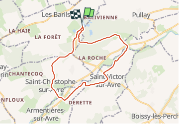
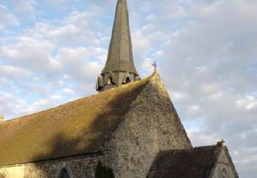
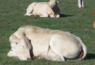
Randonnée Course à pied de 14,2 km à découvrir à Normandie, Eure, Les Barils. Cette randonnée est proposée par canuardg.

Profil altimétrique

Localisation

Pays :
France
Région :
Normandie
Département/Province :
Eure
Commune :
Les Barils
Localité :
Unknown
Départ:(UTM)
340923 ; 5399473 (31U) N.

Commentaires

Veuillez vous connecter pour laisser un commentaire ou une note


Randonnées à proximité

Randonnée Marche Bourth - Circuit du Pré Saulé - Bourth - Photo
Marche
tracegps

Marche

Facile
Bourth, Normandie, Eure, France
5,5 km | 6,2 km-effort
1h 19min
Oui
Randonnée Vélo Les Barils - Circuit découverte de villages normands - Les Barils - Photo
Vélo
tracegps

Vélo

Facile
Les Barils, Normandie, Eure, France
17,9 km | 19,7 km-effort
1h 15min
Oui
Randonnée Marche Les Barils - ballade autour de center parc les bois franc - Photo
Marche
franckaille

Marche

Très facile
Les Barils, Normandie, Eure, France
12,9 km | 14,1 km-effort
2h 7min
Non
Randonnée Marche Saint-Christophe-sur-Avre - Les Fossés Royaux - St Christophe-sur-Avre - Photo
Marche
tracegps

Marche

Facile
Saint-Christophe-sur-Avre, Normandie, Eure, France
7,2 km | 8 km-effort
1h 49min
Oui
Randonnée Marche Gournay-le-Guérin - Circuit des Fermes -  Gournay-le-Guérin  - Photo
Marche
tracegps

Marche

Facile
Gournay-le-Guérin, Normandie, Eure, France
7,3 km | 7,9 km-effort
1h 49min
Oui
Randonnée Marche Saint-Christophe-sur-Avre - st Christophe - Photo
Marche
bipf

Marche

Très facile
Saint-Christophe-sur-Avre, Normandie, Eure, France
510 m | 556 m-effort
15min
Non
Randonnée Marche Pullay - Pullay Bois Francs 10.1 Km - Photo
Marche
ODDAD78

Marche

Facile
Pullay, Normandie, Eure, France
10,1 km | 11 km-effort
2h 27min
Oui
Randonnée Marche Bourth - Bourth Circuit Pré Saul 5.5 Km - Photo
Marche
ODDAD78

Marche

Facile
Bourth, Normandie, Eure, France
5,5 km | 6,2 km-effort
1h 21min
Oui
Randonnée Marche Gournay-le-Guérin - Gournay le Guerin  - Photo
Marche
DranoelNiala

Marche

Facile
Gournay-le-Guérin, Normandie, Eure, France
8,3 km | 9,1 km-effort
2h 8min
Oui


Fermer
Mes abonnements