Randonnée A pied Bitche - Rectangle jaune-blanc-jaune - Photo

Rectangle jaune-blanc-jaune

Tous les sentiers balisés d’Europe PRO

© OpenStreetMap contributors
Longueur
Longueur
26 km
Altitude max
Altitude max
433 m
Dénivelé positif
Dénivelé positif
654 m
Km-Effort
Km-Effort  
35 km
Altitude min
Altitude min
215 m
Dénivelé négatif
Dénivelé négatif
718 m
Boucle
Boucle
Non
Balise
Balise
Date de création :
2022-02-15 15:05:57.786
Dernière modification :
2022-03-02 17:30:28.114

(0 Avis)

A pied
A pied
7h58
Difficulté : Difficile

Scannez ce code QR pour ouvrir la randonnée dans l'application SityTrail

Application GPS de randonnée GRATUITE

Logo SityTrail SityTrail

IGN / Instituts géographiques

Télécharger SityTrail sur l'App Store Télécharger SityTrail sur Google Play

Logo SityTrail SityTrail World

Le monde est à vous

Télécharger SityTrail sur l'App Store Télécharger SityTrail sur Google Play Télécharger SityTrail sur Huawei AppGallery

À propos

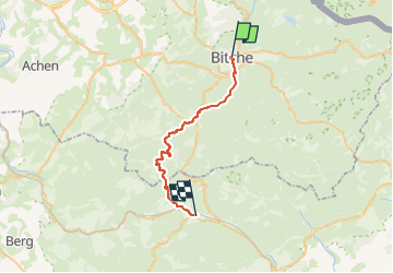
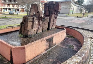
Randonnée A pied de 26 km à découvrir à Grand Est, Moselle, Bitche. Cette randonnée est proposée par SityTrail - itinéraires balisés pédestres.

Description

Randonnée créée par Club Vosgien.

Symbole: white strip on top of yellow rectangle

Photos

Localisation

Pays :
France
Région :
Grand Est
Département/Province :
Moselle
Commune :
Bitche
Localité :
Unknown
Départ:(UTM)
384867 ; 5434325 (32U) N.

Randonnées à proximité

Randonnée Marche Bitche - Etang de Hasselfurth et Hochkopf - Bitche - Photo
Marche
tracegps

Marche

Moyen
(1)
Bitche, Grand Est, Moselle, France
7,8 km | 10,1 km-effort
2h 0min
Oui
Randonnée Marche Bitche - Circuit panoramique de Bitche - Photo
Marche
tracegps

Marche

Moyen
(2)
Bitche, Grand Est, Moselle, France
12,7 km | 16,7 km-effort
3h 25min
Oui
Randonnée A pied Schorbach - Anneau bleu - Photo
A pied
PRO

A pied

Facile
Schorbach, Grand Est, Moselle, France
14,6 km | 18,7 km-effort
4h 15min
Oui
Randonnée A pied Lemberg - Anneau bleu - Photo
A pied
PRO

A pied

Facile
Lemberg, Grand Est, Moselle, France
6,1 km | 7,9 km-effort
1h 48min
Oui
Randonnée A pied Lemberg - Sentier des grottes - Photo
A pied
PRO

A pied

Facile
Lemberg, Grand Est, Moselle, France
7,9 km | 11,3 km-effort
2h 33min
Oui
Randonnée A pied Lemberg - Circuit archéologique - Photo
A pied
PRO

A pied

Facile
Lemberg, Grand Est, Moselle, France
8,7 km | 12 km-effort
2h 44min
Oui
Randonnée A pied Bitche - Triangle jaune - Photo
A pied
PRO

A pied

Facile
Bitche, Grand Est, Moselle, France
8,4 km | 10,7 km-effort
2h 26min
Non
Randonnée A pied Bitche - Disque bleu - Photo
A pied
PRO

A pied

Facile
Bitche, Grand Est, Moselle, France
10,7 km | 13,8 km-effort
3h 8min
Non
Randonnée A pied Bitche - Chevalet jaune - Photo
A pied
PRO

A pied

Facile
Bitche, Grand Est, Moselle, France
12,1 km | 18,2 km-effort
4h 7min
Non


Fermer
Mes abonnements